This item has been sold, but you can get on the Waitlist to be notified if another example becomes available, or purchase a digital scan.
1841 Lizars Map of Australia, New Zealand, and Melanesia
Australia-lizars-1841$200.00

Title
Australia etc.
1841 (undated) 17 x 19.5 in (43.18 x 49.53 cm) 1 : 19000000
1841 (undated) 17 x 19.5 in (43.18 x 49.53 cm) 1 : 19000000
Description
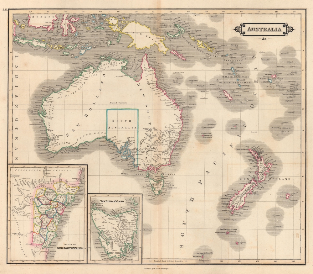
This is an 1841 William Home Lizars map of Australia (New Holland), New Zealand, and Melanesia. The map captures the region at the end of its period as a 'convict colony' but ten years before the 1851 Australian Gold Rush, which transformed the national economy.
A Closer Look
Depicting from Borneo south to Macquarie Island and from eastern Sumatra to Tonga, bays, capes, and islands are labeled all along Australia's coastline, with only a handful of settlements identified in New South Wales and the province of South Australia. Among these are Sydney, Melbourne, and Adelaide. Perth is labeled at the mouth of the Swan River. New Zealand and Tasmania are given the same attention. Islands throughout Melanesia are illustrated and labeled, with even the smallest island groups appearing. Among the labeled groups are the Solomon Islands, the Queen Charlotte Islands, the New Hebrides, Fiji, and Tonga. Insets in the lower left focus on Tasmania or Van Dieman's Land and the colony of New South Wales from Cambridge south to the Monaroo Downs. The colony is surrounded by 'unexplored territory'.Historical Context
In 1841, Australia was undergoing a period of significant growth and development, largely as a result of the ongoing expansion of European settlement. It was in the midst of the colonial era, with New South Wales, Van Diemen's Land (now Tasmania), and the recently established colony of Western Australia being the main centers of population. The economy was primarily based on wool production, mining, and agriculture, buoyed by convict labor. The Indigenous population, however, was suffering heavily from the effects of displacement, disease, and direct conflict with settlers. This year also marked the beginning of the end for the transportation of convicts to New South Wales, as the local populace was increasingly pushing for an end to the practice. The seeds of future Australian institutions and identities were being planted during this transformative period.Publication History and Census
This map was created and published by William Home Lizars for publication in his Lizars' Edinburgh Geographical General Atlas in 1841. The entire atlas is part of the David Rumsey Map Collection and is cataloged in OCLC as being part of at least a dozen institutional collections. The separate map appears on the market occasionally.Cartographer
William Home Lizars (May 4, 1788 - March 30, 1859) was a mapmaker, engraver, draughtsman, lithographer, copperplate printer, painter, and publisher active in Edinburgh, Scotland. Born in Edinburgh to Daniel Lizars (1754 - 1812) and his wife Margaret Home, William apprenticed to his father (an engraver and publisher) in 1802. Beginning in 1804, he began studying at the Trustees' Academy and began a career as a painter. After his father died in 1812, William took over the family business, abandoning his promising career as a painter. William worked in partnership with his brother Daniel Lizars (May 24, 1793 - March 14, 1875) from 1812 until the partnership was formally dissolved on October 21, 1819. William published a jigsaw puzzle in 1822 that may have been the first jigsaw puzzle produced in Scotland. After William's death, William and Alexander Keith Johnston acquired the firm, launching another great cartographic firm. William married Henrietta Wilson in 1820. After leaving the partnership, William's brother Daniel became a bookseller. In 1832, he went bankrupt and in 1833 emigrated to Canada. He died in Ontario in 1875. More by this mapmaker...
Source
Lizars, W.H., Lizars' Edinburgh Geographical General Atlas, (Edinburgh: W. H. Lizars) 1841.
Condition
Very good. Light wear along original centerfold.
References
Rumsey 0438.061. Tooley, R.V., The Mapping of Australia and Antarctica. Second Revised Edition (London: Holland Press Limited) 1985, #864.