This item has been sold, but you can get on the Waitlist to be notified if another example becomes available, or purchase a digital scan.
1794 Wilkinson Map of New South Wales, Australia
Australia-wilkinson-1794$137.50

Title
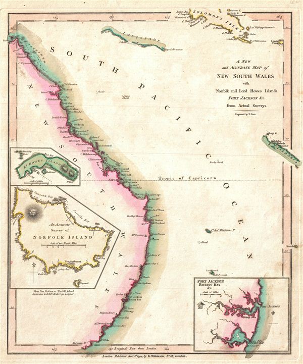
A New and Accurate Map of New South Wales with Norfolk and Lord Howes Islands Port Jackson and C. from Actual Surveys.
1794 (dated) 11.5 x 9.5 in (29.21 x 24.13 cm)
1794 (dated) 11.5 x 9.5 in (29.21 x 24.13 cm)
Description
A finely detailed first edition 1794 map of the New South Wales, Australia, by Robert Wilkinson. One of the first maps to detail the British colonization of Australia, Wilkinson's map covers eastern Australia from the endeavors Straits south as far as Furneaux Island, including Botany Bay and modern day Sidney. New Caledonia and the Solomon Islands appear in the upper right quadrant. The region of New South Wales was named by Captain James Cook, who explored the coast in 1770. The First Fleet, as it is known in Australian history, sailed from england with 1,487 colonists to settle the Australian coast in 1787. Landing near Botany Bay in 1788, the colonists of the First Fleet founded Sydney in Port Jackson, an inset of which appears in the lower right quadrant.
Another inset, in the lower left details Norfolk Island. This small Polynesian island, located roughly 290 British Leagues east of Australia, was proposed and developed by John Call as an auxiliary colony to the 1788 British settlement of New South Wales. Given its remoteness the Norfolk Island was, almost from the beginning a penal settlement, its first colonists being Lieutenant Philip Gidley King and 15 convicts.
Just above the Norfolk Island inset, a third inset details Lord Howes Island. This small irregularly shaped island off the coast of New South Wales was discovered by the first wave of British colonists to enter the region in 1788. Though uninhabited until 1834, save for a large population of sea turtles, the Island's discovery was big news back in London – a fact on which Wilkinson was quick to capitalize.
In general, this map offers good coastal detail, mostly gleaned from Cook's excellent maps, as well as some notations on geographical features further inland, including the Mt. Dromedary, Pidgeon House, Rose Hill, The Three Brothers, Mt. Warning, The Glass Houses, and Mt. Upright. engraved by Thomas Condar for the 1794 first edition of Robert Wilkinson's General Atlas. This is one of the earliest maps to detail the British colonization of New South Wales and was reissued with few changes in various atlases until about 1825.
CartographerS
Robert Wilkinson (fl. c. 1758 - 1825) was a London based map and atlas publisher active in the late 18th and early 19th centuries. Most of Wilkinson's maps were derived from the earlier work of John Bowles, one of the preeminent English map publishers of the 18th century. Wilkinson's acquired the Bowles map plate library following that cartographer's death in 1779. Wilkinson updated and retooled the Bowles plates over several years until, in 1794, he issued his first fully original atlas, The General Atlas of the World. This popular atlas was profitably reissued in numerous editions until about 1825 when Wilkinson died. In the course of his nearly 45 years in the map and print trade, Wilkinson issued also published numerous independently issued large format wall, case, and folding maps. Wilkinson's core cartographic corpus includes Bowen and Kitchin's Large English Atlas (1785), Speer's West Indies (1796), Atlas Classica (1797), and the General Atlas of the World (1794, 1802, and 1809), as well as independent issue maps of New Holland (1820), and North America ( 1823). Wilkinson's offices were based at no. 58 Cornhill, London form 1792 to 1816, following which he relocated to 125 Frenchurch Street, also in London, where he remained until 1823. Following his 1825 death, Wilkinson's business and map plates were acquired by William Darton, an innovative map publisher who reissued the General Atlas with his own imprint well into the 19th century. More by this mapmaker...
Thomas Conder (1747 - June 1831) was an English map engraver and bookseller active in London during the late 17th and early 18th centuries. From his shop at 30 Bucklersbury, London, Conder produced a large corpus of maps and charts, usually in conjunction with other publishers of his day, including Wilkinson, Moore, Kitchin, and Walpole. Unfortunately few biographical facts regarding Conder's life have survived. Thomas Conder was succeeded by his son Josiah Conder who, despite being severely blinded by smallpox, followed in his father's footsteps as a bookseller and author of some renown. Learn More...
Source
Wilkinson, R., A General Atlas being A Collection of Maps of the World and Quarters the Principal Empires, Kingdoms, and C. with their several Provinces, and other Subdivisions Correctly Delineated., (London) 1794 First Edition.
Condition
Very good. Minor marginal soiling. Original platemark visible. Blank on verso.