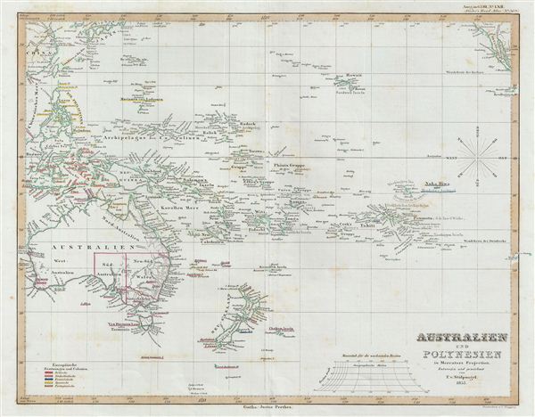
1853 Perthes Map of Australia and Polynesia in Mercator's Projection
AustraliaPolynesia-perthes-1854$200.00

Title
Australien und Polynesien in Mercators Projection.
1853 (dated) 16.5 x 13.5 in (41.91 x 34.29 cm)
1853 (dated) 16.5 x 13.5 in (41.91 x 34.29 cm)
Description
A fascinating example of the 1853 Perthes map of Australia and Polynesia. This map covers from Southeast Asia eastward as far as the Gulf of California, and from Japan Southwards to include all of Australia, Tasmania, and New Zealand. This map corrects many of the cartographic errors of the previous century and consequently most coastlines accurately rendered. Inland though, much remains confused and only tenuously explored. Vast stretches of unmapped territory and speculative cartography fill central Australia, New Zealand and Papua New Guinea. Political and regional borders are highlighted in outline color. Unlike other cartographic publishers of the period, the Justus Perthes firm did not transition to lithographic printing techniques. Instead, all of their maps are copper plate engravings and hence offer a level of character and depth of detail impossible to find in lithography or wax-process engraving. All text is in German. Designed and drawn by Friedrich von Stülpnagel and issued as plate no. 50a in the 1854 edition of Stieler's Hand-Atlas.
Cartographer
Johan Georg Justus Perthes (September 11, 1749 - May 2, 1816) was one of the most important German cartographic engravers of the 19th century. He was born in the Thuringian town of Rudolstadt, the son of a court physician. In 1778, he began working as a bookseller in Gotha. Perthes began his publishing empire shortly thereafter with the 1784 issue of the famed survey of European nobility known as the Almanac de Gotha. In the next year, 1785, he founded the cartographic firm of Justus Perthes Geographische Anstalt Gotha. His son Wilhelm Perthes (1793 - 1853) joined the firm in 1814. Wilhelm had prior publishing experience at the firm of Justus Perthes' nephew, Friedrich Christoph Perthes, who ran a publishing house in Hamburg. After Justus Perthes died in 1816, Wilhelm took charge and laid the groundwork for the firm to become a cartographic publishing titan. From 1817 to 1890. the Perthes firm issued thousands of maps and more than 20 different atlases. Along with the visionary editors Hermann Berghaus (1797 - 1884), Adolph Stieler (1775 - 1836), and Karl Spruner (1803 - 1892), the Perthes firm pioneered the Hand Atlas. When Wilhelm retired, management of the firm passed to his son, Bernhardt Wilhelm Perthes (1821 – 1857). Bernhardt brought on the cartographic geniuses August Heinrich Peterman (1822 - 1878) and Bruno Hassenstein (1839 - 1902). The firm was subsequently passed to a fourth generation in the form of Berhanrd Perthes (1858 – 1919), Bernhard Wilhelm's son. The firm continued in the family until 1953 when, being in East Germany, it was nationalized and run as a state-owned enterprise as VEB Hermann Haack Geographisch-Kartographische Anstalt Gotha. The Justus family, led by Joachim Justus Perthes and his son Wolf-Jürgen Perthes, relocated to Darmstadt where they founded the Justus Perthes Geographische Verlagsanstalt Darmstadt. More by this mapmaker...
Source
Stieler's Hand-Atlas (1854 issue).
Condition
Very Good. Original centerfold. Blank on verso.