This item has been sold, but you can get on the Waitlist to be notified if another example becomes available, or purchase a digital scan.
1852 S.D.U.K. Pocket Map of the Balkans: Croatia, Dalmatia, Sclavonia
AustrianDominionsIII-Knight-1852$65.00

Title
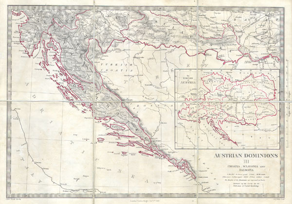
Austrian Dominions III: Croatia, Sclavonia and Dalmatia.
1852 11 x 16 in (27.94 x 40.64 cm)
1852 11 x 16 in (27.94 x 40.64 cm)
Description
This is a S.D.U.K. map of a rarely depicted portion of Europe including most of modern day Croatia. Depicts the south part of the Austrian Empire including Dalmatia, Croatia, and Sclavonia. A large inset shows the full extent of the Austrian empire. This is an unusual issue of an unusual map as it has been broken into pocket map format (six sheets) and backed with linen. This map was probably for inclusion in a library collection. Engraved by Weller for the Society for the Diffusion of Useful Knowledge under the Supervision of Charles Knight, dated Jan 1. 1852.
Cartographer
The "Society for the Diffusion of Useful Knowledge" (1826 - 1848) was a Whiggish organization founded in 1828 at the instigation of idealistic British lord Henry Peter Brougham. The admirable goal of the Society was to distribute useful information via a series of publications to the English working and middle classes. It promoted self-education and the egalitarian sharing of all knowledge. While closely tied to the London University and publishing houses on the order of Baldwin and Cradock, Chapman and Hall, and Charles Knight, the Society failed to achieve its many lofty goals in finally closed its doors in 1848. Most likely the failure of the Society resulted from its publications being too expensive for its intended lower to middle class markets and yet not large and fine enough to appeal to the aristocratic market. Nonetheless, it did manage to publish several extraordinary atlases of impressive detail and sophistication. Their most prominent atlas consisted of some 200 separately issued maps initially published by Baldwin and Cradock and sold by subscription from 1829 to 1844. Afterwards, the Society combined the maps into a single world atlas published under the Chapman and Hall imprint. In its day, this atlas was unprecedented in its quality, scope, and cost effectiveness. Today Society, or S.D.U.K. as it is commonly known, maps are among the most impressive examples of mid-19th century English mass market cartographic publishing available. The S.D.U.K. is especially known for its beautiful and accurately detailed city plans. More by this mapmaker...
Condition
Fine or perfect condition. Light age toning. Blank on verso.