This item has been sold, but you can get on the Waitlist to be notified if another example becomes available, or purchase a digital scan.
1942 Potter 951st Topographic WWII Pictorial Route Map of North Africa and Europe
AYear951-potter-1945$500.00

Title
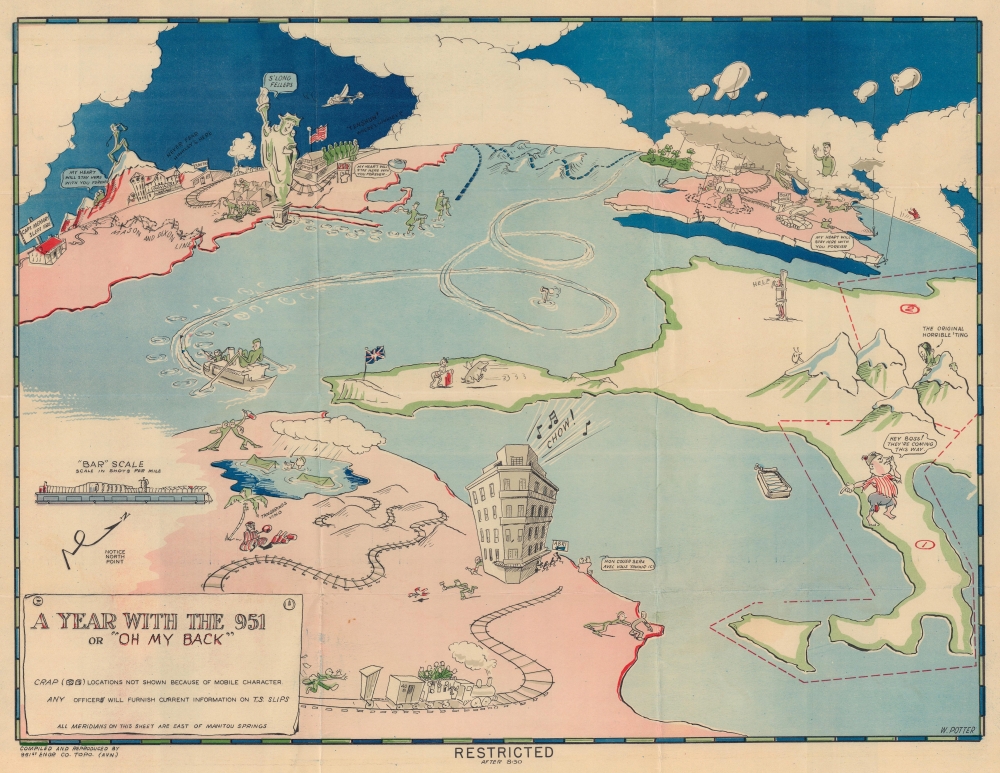
A Year with the 951 or 'Oh My Back'.
1945 (undated) 14.25 x 18.25 in (36.195 x 46.355 cm)
1945 (undated) 14.25 x 18.25 in (36.195 x 46.355 cm)
Description
This is a c. 1942 W. Potter 951st Aviation Engineer Topographic Company pictorial route map of Africa, Europe, and the United States. It is one of the most comic maps in the World War II route maps genre. Loosely tracing the company's movements through the end of 1942, Potter fills the map with hilarious vignettes and inside jokes. Curiously, this map is the only known reference to the 951st Aviation Engineer Topographic Company.
The second running joke is the illustration of two people under a blanket (obviously a GI and 'his girl') with the GI stating 'My Heart Will Stay Here With You Forever'. This scene appears twice in the U.S., once in Britain, and again in North Africa, where the soldier speaks these words of devotion in French!
North Africa
The North Africa theater of combat occupies the foreground. A large hotel on the Mediterranean coast has a line of individuals sneaking out the back, even while the call for 'Chow!' rings out from the top of the hotel. A GI is illustrated running after a desert bird with an axe, underscoring food quality issues in the North Africa theater. To the right of the hotel in Tunisia an American attempts to push a Nazi into the sea, making little progress, a likely commentary on the ongoing stalemate Rommel's Afrika Korps. Railroads cross North Africa, with a transport train heading toward the hotel and one GI chasing after. Further long the tracks, an African sells tangerines and wine. This 'vino' must have been popular, as two drunken soldiers appear at the far end of the tracks, the 'X's for eyes revealing their condition.Britain and the United States
The map follows the 951st's loosely illustrated looping route from Britain to North Africa. A periscope ominously occupies the center of one of these loops. In Britain, a soldier is at target practice while another staoks his feet after a long march. Fog and barrage balloons cover Britain, obscuring Scotland and providing an image of what must have been the stereotypical day in Britain for the 951st. Ireland is marked by a green splotch covered in shamrocks. A blue dashed line traces a route from Britain to the United States. Waves evoke a choppy transatlantic voyage. Two soldiers near Cape Cod tiptoe cautiously out of New York harbor, avoiding prowling U-boats. The second in line waves a handkerchief at the Statue of Liberty who says 'S'Long Fellers'. Images of training and the shenanigans of stateside life fill the United States. Among these are a guy being held down to get his hair cut and a soldier missing at morning rollcall.Europe
On this map, Europe is sparsely illustrated. A Union Jack marks Gibraltar and a matador and bull appear in Spain. France is personified by a young woman tied to a stake begging for help. Hitler peaks over the Alps toward Mussolini, who is dressed like a beggar. Mussolini screams 'Hey Boss! They're coming this way.' Sardinia is not an island, but a can of sardines.Running Gags
Several running jokes appear. One is a sadistic looking doctor holding a huge syringe. He appears behind the hotel in North Africa, on the ship rowing toward Morocco, behind a hill in Britain, behind one of the tents not far from the Statue of Liberty, behind the barracks during roll call, and behind the 'Navajo' (?).The second running joke is the illustration of two people under a blanket (obviously a GI and 'his girl') with the GI stating 'My Heart Will Stay Here With You Forever'. This scene appears twice in the U.S., once in Britain, and again in North Africa, where the soldier speaks these words of devotion in French!
A Personal Souvenir
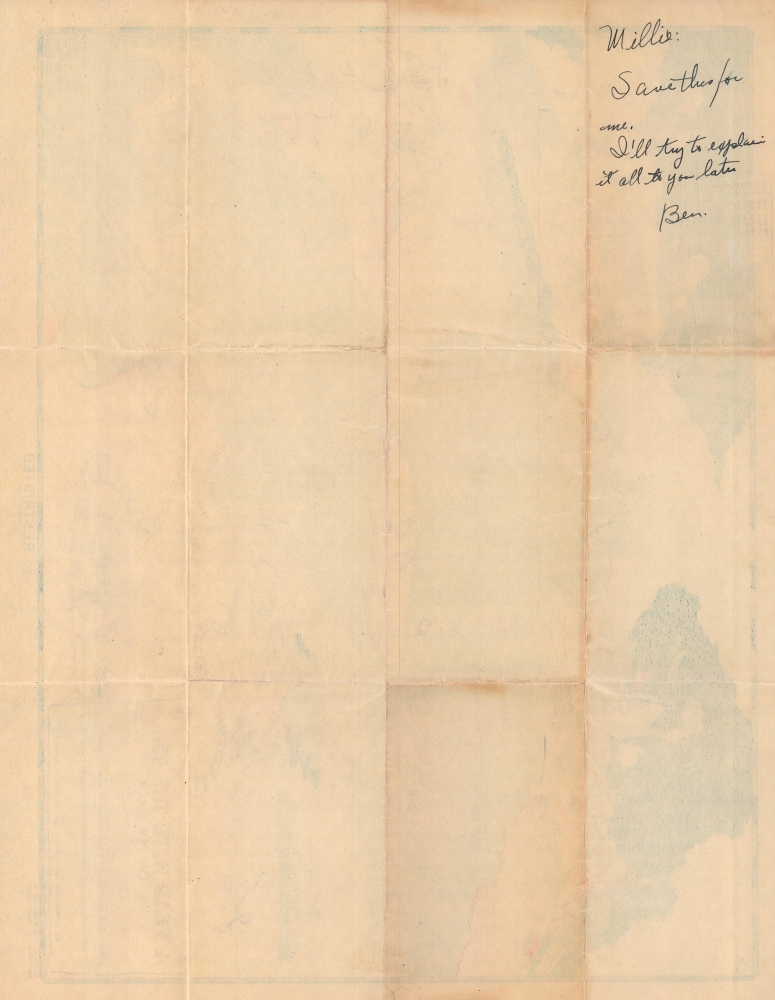
The present example of this map bears a final amazing detail. On the verso, a manuscript note reads, 'Millie: Save this for me. I'll try to explain it all to you later. Ben'. This note confirms that the present example was sent home from Europe, likely by one of the soldiers in the 951st. It also strongly suggests that many of the illustrations are in fact inside jokes that only members of the unit will understand.h6>The 951st Aviation Engineer Topographic CompanyWe have been able to piece together a very small amount of the history of the 951st Aviation Engineer Topographic Company. The company was organized in Connecticut and included 250 men. They were trained in Colorado and then were in England by December 1942. They fought in North Africa and Italy. Given that many other topographic companies and battalions printed many route maps after the war, it is likely that the 951st created and printed this one themselves. Perhaps, given that this map was likely produced during the war, it had an effect on the proliferation of the genre as the war progressed.Publication History and Census
This map was drawn by W. Potter and 'compiled and reproduced by the 951st Engineer Company Topo. (AVN.)' or 951st Aviation Engineer Topographic Company c. 1942. We are aware of one other cataloged example, located at Texas A and M University.Condition
Very good. Wear along fold lines. Manuscript note on verso.
References
OCLC 1366499915.