1915 Ordnance Survey / War Office Map of Baghdad Region, World War I
Baghdad-waroffice-1915$1,500.00


Title
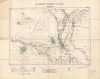
Eastern Turkey in Asia. Baghdad. Sheet 39.
1915 (dated) 25.5 x 32 in (64.77 x 81.28 cm) 1 : 250000
1915 (dated) 25.5 x 32 in (64.77 x 81.28 cm) 1 : 250000
Description
A large and important 1915 map of the region around Baghdad, then part of the Ottoman Empire, produced by the British Ordnance Survey and War Office. At this time, the region south of Baghdad was contested by British and Ottoman forces as part of the Mesopotamia Campaign of World War I (1914 - 1918). The map is also significant for being the first printed map to show the Baghdad-Tikrit Railway, part of the larger planned Berlin-Baghdad Railway.
Among the sources relied upon that are listed at bottom are the surveys of W. Willcocks in 1909 - 1910, which were printed in Lorimer's Report on a tour in Turkish Arabia and Kurdistan and were the first printed record of the Baghdad Railway to Tikrit, seen at top here. This line was part of the Berlin-Baghdad Railway begun in 1903, an ambitious project that was partially finished by 1914 but sidelined by the war and only completed in 1940.
Staying close to the Tigris and Euphrates, British forces won a succession of small battles but gradually reached far beyond their supply lines, as military leaders had feared. With time to prepare a defense of Baghdad, the Ottomans established lines south of the city near Ctesiphon (along the Tigris near bottom), where a large, several-day long battle in November 1915 was inconclusive. Both sides initially retreated, but the Ottoman commander recognized the precarious position of the British troops and turned around to pursue them. The British fell back to Kut, where they were besieged by Ottoman forces, who also quickly took measures to prevent the city's relief by another British army. Eventually, after six months, the besieged troops were forced to surrender, delivering the British a humiliating defeat. The following year, renewed efforts recaptured Kut and captured Baghdad, but the Ottomans had shown themselves to be a tougher opponent than expected, forcing the British to divert resources from elsewhere.
A Closer Look
Covering the region around Baghdad, then seat of the Ottoman Vilayet of Baghdad, this map includes a range of topographic, infrastructural, and military information that would be essential to British war planners. Roads and paths of various types and qualities (including 'metalled' roads, that is, paved roads), telegraphs, railways, waterways, fortifications, holy sites, elevation, and other features are indicated throughout. Much is made of the beds of ancient canals which fed the great city with water; a note at bottom-right reveals that these were militarily important as they rose above the surrounding countryside, creating a sort of 'natural' fortification.Among the sources relied upon that are listed at bottom are the surveys of W. Willcocks in 1909 - 1910, which were printed in Lorimer's Report on a tour in Turkish Arabia and Kurdistan and were the first printed record of the Baghdad Railway to Tikrit, seen at top here. This line was part of the Berlin-Baghdad Railway begun in 1903, an ambitious project that was partially finished by 1914 but sidelined by the war and only completed in 1940.
A Mess in Mesopotamia
Both the British and Ottomans initially considered Mesopotamia to be a secondary theater of war, but Britain became concerned about ensuring its position on the Persian Gulf and its interests in Persia (including oil refineries). In late November 1914, the British captured Basra and in April 1915 repelled an Ottoman counter-attack. These successes prompted calls for British troops to march all the way to Baghdad, especially from politicians who saw such a development as symbolically important, though military planners had doubts about such an ambitious campaign.Staying close to the Tigris and Euphrates, British forces won a succession of small battles but gradually reached far beyond their supply lines, as military leaders had feared. With time to prepare a defense of Baghdad, the Ottomans established lines south of the city near Ctesiphon (along the Tigris near bottom), where a large, several-day long battle in November 1915 was inconclusive. Both sides initially retreated, but the Ottoman commander recognized the precarious position of the British troops and turned around to pursue them. The British fell back to Kut, where they were besieged by Ottoman forces, who also quickly took measures to prevent the city's relief by another British army. Eventually, after six months, the besieged troops were forced to surrender, delivering the British a humiliating defeat. The following year, renewed efforts recaptured Kut and captured Baghdad, but the Ottomans had shown themselves to be a tougher opponent than expected, forcing the British to divert resources from elsewhere.
The Map's Provenance
A note at bottom-right discusses the provenance of this example: 'This map belonged to Sir Charles [should read 'Thomas'] Berry Cusack-Smith who commanded a R.A. [Royal Artillery] unit in Mesopotamia. Later he was a governor of Brighton College.' Prior to his military career, Cusack-Smith served as the British Consul in Samoa from 1890 to 1898, and then took the same position in Chile. In 1905, he retired to Brighton and joined the Sussex Volunteer Corps. When World War I began, he was appointed a commanding officer in the 1st Home Counties Brigade, Royal Field Artillery, with whom he served in India and Mesopotamia.Publication History and Census
This map was drawn by the Ordnance Survey and printed in 1915 by the British War Office for the Geographical Section of the General Staff (abbreviated and coded at bottom-left). The present edition is not known to exist in institutional collections or on the market, with a 1917 edition held by Princeton University.CartographerS
The British War Office (1857 - 1964) was a department of the British Government responsible for the administration of the Royal Army until 1964, when its functions were transferred to the Ministry of Defense. The War Office was to the Royal Army what the Admiralty was to the Royal Navy, and later, the Air Ministry. Within the War Office, the General Staff Topographical Section was responsible for thousands of maps issued for British intelligence and military use. The Topographical Section was renamed Geographical Section in April 1907. Many, once their military use passed, were offered through licensed agents to the general public. The sole London agent for War Office material was Edward Stanford. More by this mapmaker...
The British Ordnance Survey (1791 - present) is the national mapping agency of Great Britain and is one of the largest producers of maps in the world. This non-ministerial department of the government of the United Kingdom is responsible for producing maps of Great Britain and many of its overseas possessions. The history of the Ordnance Survey goes back as far as 1747, following the Jacobite rising, when King George II commissioned a comprehensive military survey of Scotland to assist further campaigns. The result, produced by Paul Sandby, John Mason and William Roy, was the Duke of Cumberland's Map, the first military quality map of the British Isles. This grew into the Principal Triangulation of Great Britain (1783-1853) under William Roy, and eventually lead to the creation of the Ordnance Survey in 1791. Today the Ordnance Survey produces a large variety of paper maps and digital mapping products. Its large scale maps, issued to the scale of 1:10000, available in sheet map form until the 1980s, are now only available digitally. All maps produced by the Ordnance Survey are in copyright for 50 years after publication. Learn More...
Condition
Very good. Toning and wear along fold lines.
References
OCLC 1340448076 (1917 edition).