1858 Lange Map of the Southwestern United States
BalduinMullhausenReise-lange-1858$500.00

Title
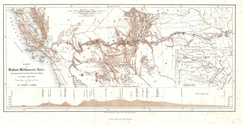
Karte zu Balduin Möllhausen's Reise vom Mississippi nach der Küste der Südsee im Jahre 1853 - 1854.
1858 (undated) 9.25 x 18 in (23.495 x 45.72 cm) 1 : 6015000
1858 (undated) 9.25 x 18 in (23.495 x 45.72 cm) 1 : 6015000
Description
This is Henry Lange's 1858 map of the southwestern United States illustrating the 'German Fenimore Cooper' Heinrich Balduin Möllhausen's participation in the 1853 Whipple Expedition, part of the Pacific Railroad Surveys.
After staying with the duke for a few months, Möllhausen accepted a job from the Prussian consul in St. Louis to accompany a shipment of zoo animals to Berlin. Möllhausen arrived in Berlin in January 1853 after having been away for four years. While in Berlin, Möllhausen was introduced to Alexander von Humboldt by the director of the Berlin Zoo. Humboldt became Möllhausen's mentor. In May 1854, Möllhausen returned to the United States at Humboldt's urging, and with that luminary's prestigious letter of introduction, was given a job as a draftsman and topographer for Lieutenant Amiel W. Whipple' Expedition. Möllhausen provided most of the illustrations for Whipple's report, serving as the expedition topographer and naturalist. Möllhausen returned to Berlin in August 1854 and published his diary of the expedition in 1858.
Möllhausen was invited to join his third and final western expedition in 1857 by its leader, Lieutenant Joseph Christmas Ives. He was appointed the expedition's 'artist and collector of natural history.' With the stated goal of testing the navigability of the Colorado River and to explore the Grand Canyon, the expedition left San Francisco in October 1857 and traveled 530 miles up the Colorado River in a specially built steamboat before continuing on foot into the Grand Canyon. The expedition ended on May 23, 1858, at Fort Defiance in Arizona. Möllhausen's illustrations are among the first published views of the Grand Canyon.
Möllhausen returned to Germany in 1858. He spent the rest of his life writing adventure stories based on his experiences in America, becoming known as the German James Fenimore Cooper.
A Closer Look
A dashed line traced in manuscript follows the Whipple Expedition's route from Fort Smith, Arkansas, to Los Angeles, California. Numerous landmarks are identified, including rivers, hills, settlements, frontier forts, mountain peaks, and passes. Native American tribes are named. An inset in the lower right focuses on the region north of the central map, extending coverage to Nebraska and Iowa. A profile from Fort Smith to the Pacific occupies the lower portion of the sheet.The Whipple Expedition
Part of the Pacific Railroad Surveys authorized by Congress in 1853, the Whipple Expedition was led by Lieutenant Amiel Weeks Whipple (1817 - 1863). It left Fort Smith, Arkansas, with 70 men on July 15, 1853, and surveyed along the 35th parallel. Whipple's expedition crossed Indian Territory (modern-day Oklahoma), the Texas panhandle, the New Mexico Territory, and California before arriving in Los Angeles on March 20, 1854. While the goal of the expedition was to survey a route for a Pacific railroad, Whipple's expedition also produced considerable scientific data. Twelve scientists were among the expedition's complement: a French geologist, a German artist-topographer (Möllhausen), an American botanist, and even Whipple (a devoted ethnologist). Its findings, along with the other Pacific Railroad Surveys, were published by the U.S. government in the Pacific Railroad Reports, an enormous twelve-volume report, with volumes III and IV containing Whipple's reports.Heinrich Balduin Möllhausen
Heinrich Balduin Möllhausen (1825 - 1905) was a German author, artist, and traveler. He took part in three expeditions exploring the American frontier. Born in Bonn, Prussia, Möllhausen attended school in Bonn before having to withdraw for financial reasons. He worked in agriculture for a while and considered a career in the army, but, after participating in the failed Revolution of 1848, fled Europe for the United States in 1849. He spent the next two years in Illinois and Missouri. In 1851, he encountered Duke Paul Wilhelm of Württemberg, who invited Möllhausen to join his scientific expedition to the Rocky Mountains. The trip across the plains to Fort Laramie was uneventful, but the return trip was harrowing. A prairie fire and hostile Indians caused waylaid the group, and an early snowstorm killed their horses, leaving them stranded. At some point a mail coach appeared, but only had room for one passenger. The duke took that place and left Möllhausen to fend for himself. He spent months alone on the prairie, dealing with famine, cold, and hostile Indians. He was finally rescued in January 1852 by a band of friendly Otoes, and several months later, he reached New Orleans and reunited with the duke.After staying with the duke for a few months, Möllhausen accepted a job from the Prussian consul in St. Louis to accompany a shipment of zoo animals to Berlin. Möllhausen arrived in Berlin in January 1853 after having been away for four years. While in Berlin, Möllhausen was introduced to Alexander von Humboldt by the director of the Berlin Zoo. Humboldt became Möllhausen's mentor. In May 1854, Möllhausen returned to the United States at Humboldt's urging, and with that luminary's prestigious letter of introduction, was given a job as a draftsman and topographer for Lieutenant Amiel W. Whipple' Expedition. Möllhausen provided most of the illustrations for Whipple's report, serving as the expedition topographer and naturalist. Möllhausen returned to Berlin in August 1854 and published his diary of the expedition in 1858.
Möllhausen was invited to join his third and final western expedition in 1857 by its leader, Lieutenant Joseph Christmas Ives. He was appointed the expedition's 'artist and collector of natural history.' With the stated goal of testing the navigability of the Colorado River and to explore the Grand Canyon, the expedition left San Francisco in October 1857 and traveled 530 miles up the Colorado River in a specially built steamboat before continuing on foot into the Grand Canyon. The expedition ended on May 23, 1858, at Fort Defiance in Arizona. Möllhausen's illustrations are among the first published views of the Grand Canyon.
Möllhausen returned to Germany in 1858. He spent the rest of his life writing adventure stories based on his experiences in America, becoming known as the German James Fenimore Cooper.
Publication History and Census
This map was drawn by Dr. Henry Lange for publication in Balduin Möllhausen's 1858 Tagebuch Einer Reise vom Mississippi nach den Küsten der Südsee. We note a single cataloged example of the separate map, part of the collection at the University of Utah. The full volume appears in 15 institutional collections worldwide. The separate map is scarce on the market.Cartographer
Henry Lange (April 13, 1821 - August 30, 1893) was a German writer and cartographer. Born in Stettin, Lange attended Heinrich Berghaus's cartography school in Potsdam. For three years, beginning in 1844, Lange worked on Scottish geographer Alexander Keith Johnston's (1804 - 1871) first Physical Atlas. He returned to Germany in 1847 and worked as a freelance cartographer in Berlin. During this time he produced maps for researchers and publishers in Berling, including Alexander von Humboldt, Heinrich Kiepert, Heinrich Barth, and Carl Ritter. Lange set up the cartographic department for FA Brockhaus, a publishing house in Leipzig, between 1855 and 1859, after which he returned to creating commissioned works. He earned a position wit the Royal Statistical Office in 1868, a position he held until he retired in 1891. Lange played an instrumental role in founding the Central Association for Commercial Cartography and the promotion of German interests abroad. During the course of his career, Lange produced hand and travel atlases, Bible atlases, and works of industrial and commercial geography. He is most often remembered for his works of school cartography, which were published by George Westermann (1810 - 1879). Among these were the Neuesten Schulatlas sum Unterrichte in der Erdkunde, for which he made revisions for ninety editions until 1892. Another of his extremely successful school atlases Neue Volkschulatlas über all Teile Der Erde had over 230 editions and printed over 2.4 million printed copies from 1871 until Lange's death. More by this mapmaker...
Source
Möllhausen, B., Tagebuch Einer Reise vom Mississippi nach den Küsten der Südsee, (Leipzig: Hermann Mendelssohn) 1858.
Condition
Very good. Foxing.
References
University of Utah 1081821.