
This item below is out of stock, but another example (left) is available. To view the available item, click "Details."
Details
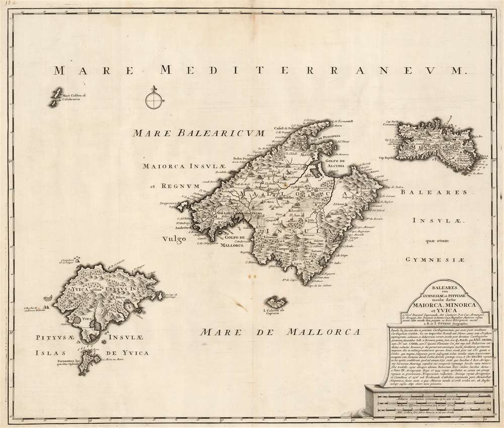
1725 Ottens Map of the Balearic Islands: Mallorca, Menorca, and Ibiza
1725 (undated) $2,800.00
1720 Ottens Map of Mallorca, Menorca and Ibiza
Balearides-ottens-1720$1,400.00

Title
Baleares seu Gymnesiae et Pityusae insulae dictae Maiorca, Minorca et Yvica.
1720 (undated) 19 x 22.5 in (48.26 x 57.15 cm) 1 : 600000
1720 (undated) 19 x 22.5 in (48.26 x 57.15 cm) 1 : 600000
Description
This is a superbly detailed map of the Balearic Islands by Renard and Josua Ottens, in what appears to be a scarce early state, as early as 1720. The map is oriented to the north, and includes the major islands of Mallorca, Menorca, Ibiza, and Formentera as well as the smaller Cabrera, Dragonera, and Monte Colibre. Mallorca and Menorca, in particular, are superbly detailed. All the major islands' terrain is richly and expertly engraved, illustrating topography, forests, and cultivated areas pictorially. Roads, cities, salt flats, and fortifications are depicted. Anchorages are indicated, in several cases with depth soundings. The elegant, spare cartouche features a brief history of the rulers of the islands, up to the English capture and occupation of Menorca in 1708.
The evidence suggests that Ottens not only had awareness of the Van Keulen maps, but also appears to have been aware of Mut's original. This, alongside the very similar engraving style of both the Van Keulen precursor maps to the present work, suggests that the elder Ottens may in fact have engraved the Van Keulen charts. Ottens is on record having engraved works for De Wit and would have been available to do the jobs in Amsterdam, but his imprint does not appear. Beyond the obvious similarities of the works, we are left to speculate.
The Sources
The detail of both Mallorca and Menorca is clearly derived from the separate maps of Mallorca and Minorca produced in and around 1710 by Johannes van Keulen, and appearing in his Zee Fakkel. Indeed, the Ottens map not only reproduces Van Keulen's geographical treatment of Mallorca, but also includes a Latin translation of the historical gloss on the Balearides that appears on the Van Keulen. The Van Keulen Mallorca, however, was derived from a 1683 map engraved by the Mallorcan soldier and scholar Vicente Mut i Armengol (1614–1687,) which appears to have been the first map of that island produced by someone who lived there. Ottens also appears to have had direct knowledge of the Mut map independently of Van Keulen, as well: in the title, Ottens names the sources which are listed by Mut on his 1683 map, but do not appear on Van Keulen's work.Broader Scope
The Ottens is not a rote copy of the Van Keulen. While the information for Mallorca is clearly sourced from the Van Keulen map of that island, Ottens' map includes both Ibiza and Menorca. The latter drawn from the separate Van Keulen map of the island. We are not aware of the precursor map for Ottens' Ibiza, however.The evidence suggests that Ottens not only had awareness of the Van Keulen maps, but also appears to have been aware of Mut's original. This, alongside the very similar engraving style of both the Van Keulen precursor maps to the present work, suggests that the elder Ottens may in fact have engraved the Van Keulen charts. Ottens is on record having engraved works for De Wit and would have been available to do the jobs in Amsterdam, but his imprint does not appear. Beyond the obvious similarities of the works, we are left to speculate.
Publication History and Census
It is not at all clear precisely when the present map was engraved. It has been catalogued with the wildly imprecise dates of 1725-1750. Ottens had no formal atlas, and so the usual methods of dating such maps are denied us. The map lacks a privilege, which suggests an earlier date: we begin to see the Ottens privilege added to maps in and around 1725. We are aware of two states of this map, the latter of which includes an extensive historical gloss drawing heavily on classical scholars, including Strabo and Mela. Our example lacks the gloss, and thus would appear to be the earliest known state of the map. It also appears to be the scarcer of the two.CartographerS
Ottens (fl. c. 1680 - 1785) was a prominent Amsterdam map publishing family active for nearly 100 years. Joachim Ottens (1663 - 1719) was born in Amsterdam to a family of seafarers and educated in Amsterdam's Evangelical Lutheran community. He likely learned copperplate engraving under Frederick de Wit (1629 - 1706), for whom he worked until about 1710. In 1710, he was admitted to the Sint-Lucasgilde (Guild of St. Luke) and, in 1711, Joachim founded his own firm. Although Joachim died only a few years later, in 1719, his widow continued the business, either publishing as either 'I. Ottens', 'Ottens', or 'In de Wereldcaert' [In the World Map]. In 1726, Joachim Otten's sons, Renier (1698 - 1750) and Joshua (1698 - 1750), established a partnership and generally published as 'R. and I. Ottens'. Although they ran separate shops, on Nieuwendijk and Kalverstraat, they worked jointly as a singular business until Renier's death in 1750, at which point Joshua assumed full control. After Joshua's death in 1765, his widow continued the firm with their son, Renier II, changing the imprint to 'Joshua and Reinier Ottens.' Joshua's widow, Johanna de Lindt, held an auction sale of their engraved plates in 1784. Ottens' work stands out in that all of their maps were separate issues, though often found compiled into special, made-to-order multi-volume composite Atlas factice works, such as the Atlas. Some examples of the Atlas include over 800 separately issued maps. Because they were not uniformly issued in standard atlases, Ottens maps are often of the utmost rarity and are notable for their exceptionally rich engraving. More by this mapmaker...
Gerard van Keulen (1678 - 1726) was a Dutch map publisher and engraver active in Amsterdam during the late 17th and early 18th centuries. Gerard was the son of the more famous Johannes Van Keulen (1654 – 1715) and eventually took over his father's business. He also negotiated to take over the Privilege of Willem Blaeu, thus becoming the official cartographer of the Dutch East India Company (VOC). He was married to Ludowina Konst (16??? - 1740). Gerard is credited with nearly 500 charts and maps published between 1706 and his death in 1726. He also continued to update and republish his family's legendary Zee-Fakkel, often described as the 'Secret Atlas' as it was restricted to VOC pilots. After his death, the firm was passed on to Gerard's son, Johannes II Van Keulen (1704 - 1755), who significantly updated the atlas. The final true Van Keulen editions of the atlas were published by Gerard Hulst Van Keulen (1733 - 1801), Johannes II's son. The final edition of the Zee-Fakkel was published posthumously in 1803. Afterward, the firm fell into the hands of the Swart family, who managed it for several generations until it finally closed its doors in 1885. It is noteworthy that though ostensibly controlled by the Van Keulen men, it was their widows who maintained and managed the firm in the periods following their husbands' deaths. Learn More...
Vicente Mut i Armengol (1614–1687) was a Mallorcan astronomer, engineer, historian, mathematician and soldier. He wrote treatises on artillery, astronomy and Mallorcan history, and helped build the city defenses of Mallorca. In 1686 he engraved, or caused to be engraved, a detailed map of Mallorca - very likely the first printed map of the island produced by someone who lived there. Learn More...
Condition
Very good. Few surface spots, else excellent with a bold, sharp strike.
References
OCLC 431784212.