1954 Admiralty Navigational Map of the Strait of Bali
Bali-admiralty-1954$200.00


Title
Eastern Archipelago Straat Bali from the Netherlands Government Chart of 1907 With Corrections to 1954.
1954 (dated) 38.5 x 25.75 in (97.79 x 65.405 cm) 1 : 200780
1954 (dated) 38.5 x 25.75 in (97.79 x 65.405 cm) 1 : 200780
Description
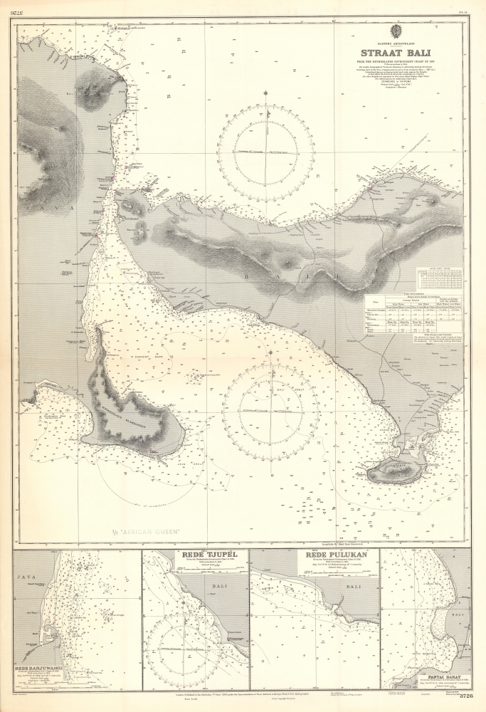
This is a British nautical map of the Bali Strait, the narrow passage between the islands of Java and Bali, from among the charts of a working oil tanker. The chart is derived from a 1907 Dutch chart produced while the island was a colonial possession. This Admiralty chart, though initially engraved in 1909, was corrected and reprinted in 1954. The chart shows the easternmost coastlines of Java, and the coasts of the western half of Bali. In addition to the expected depth soundings and notations of magnetic variations, the chart is remarkably well-detailed with respect to the coastlines. Elevations are shown topographically, lighthouses are marked in red, and visually important landmarks are noted: Temples, a pyramid, and even 'House with Zinc Roof (conspicuous)' appear as references for the coastal navigator.
Insets of Safe Anchorages
The insets show redes - roadsteads, or safe anchorages - of harbors shown on the main chart. These include Banjuwangi (a town on the eastern end of Java, at the southern mouth of the Bali Strait) and the Tjupel coast across the Strait from Banjuwangi; Pulukan, further south along the Bali coast and Pantai Barat, at the southern extremity of Bali's west coast. All of these anchorages would have been essential for ships navigating the Straits shown on the main chart.The African Queen
While, alas, not related to her namesake immortalized by Bogart and Hepburn, the T/T African Queen had stories of her own. A Norwegian tanker, the (Liberian registered) 'African Queen' would remain afloat only four years after adding this chart to her library. On December 10th, 1958, she ran aground on Gull Shoal and broke up off the coast of Ocean City, Maryland with a crew of 46 and a cargo of 21,000 tons of crude oil, bound for the Mobil refinery at Paulsboro, N.J., on the Delaware River. The captain and crew survived, abandoning the ship - which would become target for countless collectors, salvage speculators, and other pickers over the next year. The stern was eventually raised and brought to port - a boondoggle. The bow remains on the bottom of the ocean.Publication History and Census
Admiralty charts such as this one were produced in large numbers, but heavily used, and typically were destroyed when obsolete. They are neglected in institutional collections, as is this one, which has not been cataloged in OCLC.Cartographer
The British Admiralty Office (1795 - Present) or the United Kingdom Hydrographic Office refers to the Branch of the English government that is responsible for the command of the British Navy. In 1795 King George III created the United Kingdom Hydrographic Office, known in short as the U.K.H.O., to provide top notch nautical charts to the vast Royal Navy. Prior the founding of the Admiralty the surveying and creation of nautical charts was primarily a commercial venture wherein the cartographer himself, more of than not, actually financed the printing of his own material. The great navigator Cook himself is known to have scrambled for funds to publish his own seminal charts - the most important and advanced of the period. The system of privately funded nautical mapping and publishing left vast portions of the world uncharted and many excellent charts unpublished. King George III, responding significant loss in trade revenue related to shipwrecks and delay due to poor charts, recognized the need for an institutionalized government sponsored cartographic agency - the Admiralty. The first head of the Admiralty, a position known as Hydrographer, was the important cartographer Alexander Dalrymple. Dalrymple started by organizing and cataloging obtainable charts before initiating the laborious process of updating them and filling in the blanks. The first official Admiralty Chart appeared in 1800 and detailed Quiberon Bay in Brittany. By 1808 the position of Hydrographer fell to Captain Thomas Hurd. Hurd advocated the sale of Admiralty charts to the general public and, by the time he retired in 1829, had issued and published some 736 charts. Stewardship of the organization then passed to Rear Admiral Sir Francis Beaufort. It was under Beaufort's administration that the Admiralty truly developed as a "chart making" as opposed to a "chart cataloging" institution. Beaufort held his post from 1829 to 1854. In his 25 years at the Admiralty Beaufort created nearly 1500 new charts and sponsored countless surveying and scientific expeditions - including the 1831 to 1836 voyage of the H.M.S. Beagle. By 1855 the Admiralty's chart catalog listed some 1,981 charts. More by this mapmaker...
Condition
Very good condition. Slight dogear at corners. Ship's library stamp 'T/T African Queen' on recto and verso.