This item has been sold, but you can get on the Waitlist to be notified if another example becomes available, or purchase a digital scan.
1760 Bellin Map of Bali, Indonesia
Bali-bellin-1760$200.00

Title
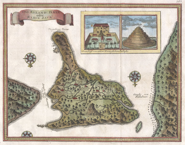
Das Eyland Baly oder Klein Java.
1760 (undated) 7 x 8.75 in (17.78 x 22.225 cm)
1760 (undated) 7 x 8.75 in (17.78 x 22.225 cm)
Description
An extremely attractive little map of Bali, Indonesia, by French cartographer J. Nicholas Bellin. Depicts the island oriented to the south. Offers wonderful detail of the inland rivers and villages. Upper right quadrant features an inset of the Royal Palace and a Balinese temple. Two and a half compass roses decorate the image. The island of Java is shown to the right and Lombok to the left. The upper left quadrant features a banner style title cartouche. Most likely prepared for the Dutch edition of Provost's L'Histoire Generale des Voyages.
Cartographer
Jacques-Nicolas Bellin (1703 - March 21, 1772) was one of the most important cartographers of the 18th century. With a career spanning some 50 years, Bellin is best understood as geographe de cabinet and transitional mapmaker spanning the gap between 18th and early-19th century cartographic styles. His long career as Hydrographer and Ingénieur Hydrographe at the French Dépôt des cartes et plans de la Marine resulted in hundreds of high quality nautical charts of practically everywhere in the world. A true child of the Enlightenment Era, Bellin's work focuses on function and accuracy tending in the process to be less decorative than the earlier 17th and 18th century cartographic work. Unlike many of his contemporaries, Bellin was always careful to cite his references and his scholarly corpus consists of over 1400 articles on geography prepared for Diderot's Encyclopedie. Bellin, despite his extraordinary success, may not have enjoyed his work, which is described as "long, unpleasant, and hard." In addition to numerous maps and charts published during his lifetime, many of Bellin's maps were updated (or not) and published posthumously. He was succeeded as Ingénieur Hydrographe by his student, also a prolific and influential cartographer, Rigobert Bonne. More by this mapmaker...
Condition
Very good condition. Original publisher's crease. Else clean and fine.