This item has been sold, but you can get on the Waitlist to be notified if another example becomes available, or purchase a digital scan.
1738 Ratelband Map of the Balkans ( Bosnia, Serbia, Bulgaria, Rumania )
Balkans-lafeuille-1738$100.00

Title
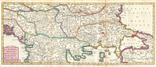
Nieuwe Kaart van Bosnien, Servien, Bulgarien, Romanien; Graeciae enz..
1738 7 x 16.25 in (17.78 x 41.275 cm)
1738 7 x 16.25 in (17.78 x 41.275 cm)
Description
This is a rare and unusual 1738 map of the Balkans by J. Ratelband. Likely revised and updated from earlier charts by the De La Feuille family. Depicts from modern day Albania (Dalmatia) eastward through Bosnia, Serbia, Bulgaria and Rumania to the Black Sea (Pontus Euxinus). Extends south as far as modern Greece and includes parts of Asia Minor in the lower right quadrant. Prominently labels the cities of Constantinople (Istanbul, Andrinopoli, Belgrade, and Sophia. Curiously the location of the ancient city of Troy is also labeled with considerable accuracy considering that it was supposedly 'lost' until Heinrich Schliemann 'discovered' it in 1870. Dutch title cartouche in the lower left quadrant. This map was originally prepared for inclusion as chart no. 11 in Ratelband and Gerrevink's extremely rare 1838 Dutch hand atlas Geographisch-Toneel, Of uitgezochte Karten Tot Gemak der Officieren, Reisigers en Liefhebbers…'
Cartographer
Daniel de La Feuille (1640 - 1709) was born of Huguenot stock in Sedan (L'Ardennes), France. As a young man he apprenticed as a watchmaker. In 1663 La Feuille married Charlette Marlet, the daughter of a local carpenter. Twenty years later, in 1683, facing religious prosecution of Huguenots in France, the family fled to Amsterdam. By 1686 Daniel had become a burgher (citizen) of the city and established himself as an engraver, publisher, and art dealer. Not long after, in 1691, he was admitted into the Booksellers Guild. Though we are primarily concerned with his cartographic work here, his masterpiece is considered to be Devises et emblems, a collection of symbols and designs mostly likely intended as templates for silversmiths, engravers, and watchmakers. His cartographic work includes numerous individual maps and atlases, many of which continued to be published and republished well after his death in 1709. He was succeeded by his sons Jacob de la Feuille (1668 - 1719) and Paul de La Feuille (1688 - 1727). More by this mapmaker...
Condition
Very Good condition. Minor discoloration along the original folds – see photo. Original plate-mark visible. Else clean.