1846 Bradford City Plan of Baltimore, Maryland
Baltimore-bradford-1846$350.00

Title
Baltimore.
1846 (dated) 12 x 15 in (30.48 x 38.1 cm) 1 : 25000
1846 (dated) 12 x 15 in (30.48 x 38.1 cm) 1 : 25000
Description
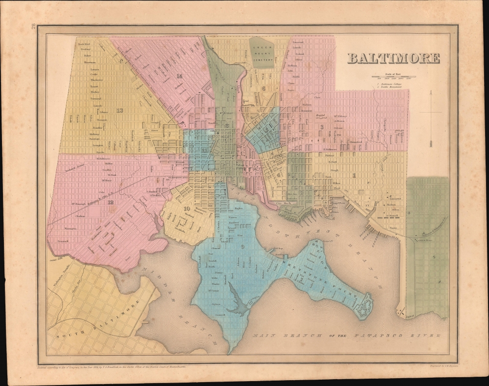
This is Thomas Bradford's 1846 city plan or map of Baltimore, Maryland, as it appeared in his Universal Illustrated Atlas. The map captures Baltimore at the height of its mid-19th-century growth spurt.
Other landmarks, such as Fort McHenry and the monument commemorating its bombardment in 1814, are noted. Several other public buildings and parks are indicated (in the former case with black rectangles) but are not labeled. Roads (such as the Washington Turnpike towards the bottom-left) and railroads (the Susquehanna at the top, the Baltimore and Ohio at the left, and the Baltimore and Wilmington at the right) connected Baltimore with other cities in the mid-Atlantic region.
A Closer Look
The entirety of contemporary Baltimore is shown, along with South Baltimore and Canton. City wards are numbered and color-shaded. Much of the street grid along the outskirts of the city's center is ghosted in, with pre-existing waterways displayed, reflecting the city's rapid growth and anticipated expansion. City hall, markets, a hospital (the 'City Hospital'), a jail, and other buildings are labeled, including the Maryland Penitentiary (now the Metropolitan Transition Center), the first such institution in the state and the second 'modern' prison in the United States. Baltimore Basilica, in the northern part of the city, was the first Catholic cathedral built in the American Republic. The 'University' and 'College' both appear to be forerunners to the University of Maryland, Baltimore.Other landmarks, such as Fort McHenry and the monument commemorating its bombardment in 1814, are noted. Several other public buildings and parks are indicated (in the former case with black rectangles) but are not labeled. Roads (such as the Washington Turnpike towards the bottom-left) and railroads (the Susquehanna at the top, the Baltimore and Ohio at the left, and the Baltimore and Wilmington at the right) connected Baltimore with other cities in the mid-Atlantic region.
Historical Context
Mid-19th century Baltimore grew rapidly due to increasing commercial and maritime links with cities and ports both near and far (the neighborhood of Canton at bottom-right was named for the Chinese port by John O'Donnell, a merchant who had traded there before settling in Baltimore). It was the second largest city in the U.S. throughout the first half of the 19th century, after New York (though Philadelphia was typically larger when including adjacent townships, districts, and boroughs in Philadelphia County). Baltimore gained a reputation as an intellectual center willing to experiment with new ideas and techniques, especially in education, where it pioneered modern professional education in the U.S., including medicine, dentistry, and law.Publication History and Census
Despite the date of the copyright at bottom-left, this map was published in the 1846 edition of Bradford's Universal Illustrated Atlas. It can be readily distinguished from earlier editions by examining the number and configuration of city wards highlighted by the map's design.CartographerS
Thomas Gamaliel Bradford (1802 - 1887) was born in Boston, Massachusetts, where he worked as an assistant editor for the Encyclopedia Americana. Bradford's first major cartographic work was his revision and subsequent republishing of an important French geography by Adrian Balbi, Abrege de Geographie published in America as Atlas Designed to Illustrate the Abridgment of Universal Geography, Modern and Ancient. Afterwards Bradford revised and expanded this work into his own important contributions to American cartography, the 1838 An Illustrated Atlas Geographical, Statistical and Historical of the United States and Adjacent Countries. Bradford's cartographic work is significant as among the first to record Texas as an independent nation. In his long career as a map publisher Bradford worked with William Davis Ticknor of Boston, Freeman Hunt of New York, Charles De Silver of Philadelphia, John Hinton, George Washington Boynton, and others. We have been able to discover little of Bradford's personal life. More by this mapmaker...
George Washington Boynton (fl. c. 1830 - 1850) was a Boston based cartographer and map engraver active in the first half of the 19th century. Boynton engraved and compiled maps for numerous publishers including Thomas Bradford, Nathaniel Dearborn, Daniel Adams, and S. G. Goodrich. His most significant work is most likely his engraving of various maps for Bradford's Illustrated Atlas, Geographical, Statistical, and Historical, of the United States and the Adjacent Countries and Universal Illustrated Atlas. He also engraved for the Boston Almanac. In 1835, Boynton is listed as an employee of the Boston Bewick Company, an engraving, stereotype, and printing concern based at no. 47 Court Street, Boston. Little else is known of his life. Learn More...
Source
Bradford, T. G. and Goodrich, S. G., A Universal Illustrated Atlas, exhibiting a Geographical, Statistical, and Historical view of the World, (Boston: Charles D. Strong) 1846.
The Universal Illustrated Atlas is one of the great American atlases of the first half of the 19th century. The atlas was first published in 1838 under the imprint of Charles D. Strong. It replaced and superseded Bradford's earlier smaller format Illustrated Atlas, Geographical, Statistical, and Historical, of the United States and the Adjacent Countries. Numerous reissues of the Universal Illustrated Atlas followed until about 1848. Although there are minor variations between the editions, most contain about 50 maps, the majority of which focus on the United States. Bradford's atlases are significant for recording North America during the Republic of Texas Era. In later editions, particularly the 1846 edition, Bradford illustrates the boom in railroad construction, possibly with the idea that his maps would aid travelers in planning journeys by rail. It was compiled by Thomas Gamaliel Bradford and Samuel Griswold Goodrich with most of the plates engraved by George Washington Boynton (fl. c. 1830 - 1850). Other contributors include Thomas Gordon (1778 - 1848), Fielding Lucas Jr. (1781 - 1854), Samuel Edward Stiles (1844 - 1901), Sherman and Smith (fl. c. 1829 - 1855), and Horace Thayer (1811 - c. 1874).
Condition
Good. Light foxing and soiling.
References
Rumsey 4453.026 (1841 Edition).