This item has been sold, but you can get on the Waitlist to be notified if another example becomes available, or purchase a digital scan.
1892 Johns Hopkins and U.S.G.S. Map of Baltimore and Vicinity
Baltimore-usgs-1892$100.00

Title
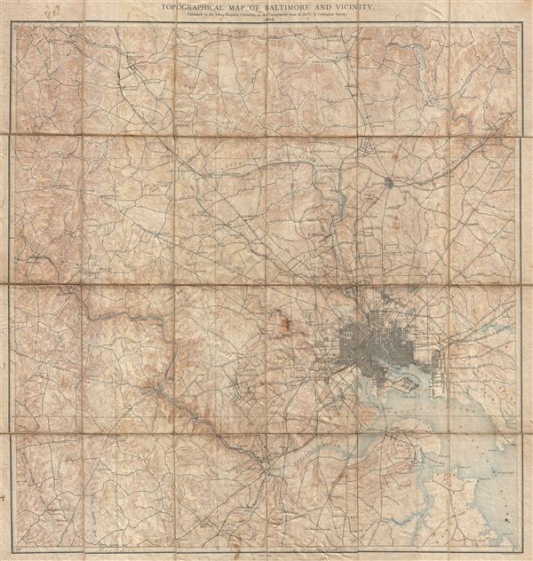
Topographical Map of Baltimore and Vicinity.
1892 (dated) 26 x 24 in (66.04 x 60.96 cm)
1892 (dated) 26 x 24 in (66.04 x 60.96 cm)
Description
A rare and unusual discovery. Ostensibly this is a fine example of 1892 U. S. Geological Survey map of Baltimore, Maryland, and vicinity. However, the United States Geological Survey never issued such a map. Instead this an uncommon publication issued by Johns Hopkins University based on earlier U.S.G.S. Survey work. The folding map, which is dissected and backed on linen, covers the city of Baltimore and its immediate vicinity from Marble Hill to Furnace Creek. It offers extraordinary detail to the level of streets and often individual buildings, noting St. Charles College, Sheppard Asylum, etc. Villages and towns around Baltimore, including Oxford, Waverly, Friendship, Hampden, among others, are also noted. The city boundary is clearly marked as are various roadways, railroads, mills, rivers, creeks, lakes and various other topographical features. . The map was published by the Johns Hopkins University, based on U.S.G.S. surveys, in 1892.
Cartographer
The Office of the Coast Survey (later the U.S. Geodetic Survey) (1807 - present), founded in 1807 by President Thomas Jefferson and Secretary of Commerce Albert Gallatin, is the oldest scientific organization in the U.S. Federal Government. Jefferson created the "Survey of the Coast," as it was then called, in response to a need for accurate navigational charts of the new nation's coasts and harbors. The first superintendent of the Coast Survey was Swiss immigrant and West Point mathematics professor Ferdinand Hassler. Under the direction of Hassler, from 1816 to 1843, the ideological and scientific foundations for the Coast Survey were established. Hassler, and the Coast Survey under him developed a reputation for uncompromising dedication to the principles of accuracy and excellence. Hassler lead the Coast Survey until his death in 1843, at which time Alexander Dallas Bache, a great-grandson of Benjamin Franklin, took the helm. Under the leadership A. D. Bache, the Coast Survey did most of its most important work. During his Superintendence, from 1843 to 1865, Bache was steadfast advocate of American science and navigation and in fact founded the American Academy of Sciences. Bache was succeeded by Benjamin Pierce who ran the Survey from 1867 to 1874. Pierce was in turn succeeded by Carlile Pollock Patterson who was Superintendent from 1874 to 1881. In 1878, under Patterson's superintendence, the U.S. Coast Survey was reorganized as the U.S. Coast and Geodetic Survey (C & GS or USGS) to accommodate topographic as well as nautical surveys. Today the Coast Survey is part of the National Oceanic and Atmospheric Administration or NOAA. More by this mapmaker...
Source
Published by the Johns Hopkins University on the topographic base of the U. S. Geological Survey. George H. Wiliams, Editor. Geology of the Sedimentary Formations by N.H. Darton, geology of the Crystalline Rocks by G. H. Williams.
Condition
Good. Dissected and mounted on linen. Even overall toning. Verso linen fragile.
References
OCLC: 55212657.