This item has been sold, but you can get on the Waitlist to be notified if another example becomes available, or purchase a digital scan.
1751 Bellin map of Chao Phraya, Ayutthaya and Bangkok
Bankok-bellin-1751$125.00

Title
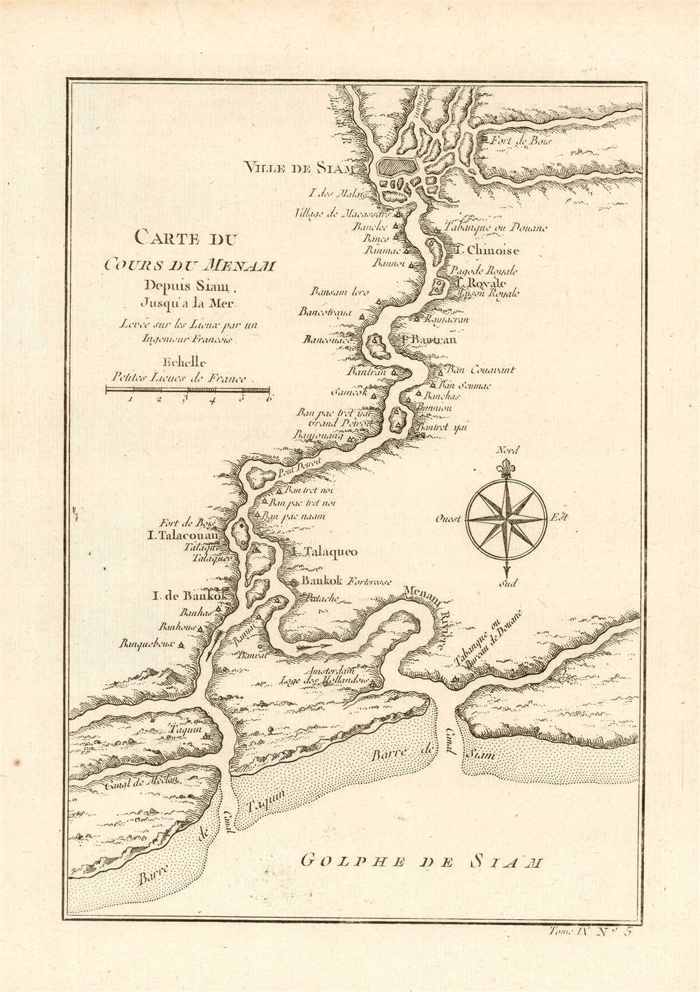
Carte du Cours Du Menam Depuis Siam Jusqu'a La Mer Levee sur los Lieux par un Ingenieur Francois
1751 (undated) 9 x 6 in (22.86 x 15.24 cm) 1 : 600000
1751 (undated) 9 x 6 in (22.86 x 15.24 cm) 1 : 600000
Description
This is an elegant 1752 Bellin map of Bangkok and its surroundings. It details the course of the Chao Phraya River from the former Thai royal capital Ayutthaya (known to Europeans as the 'Ville de Siam'), past the small trading post of 'Bankok,' (Bangkok) to the Gulf of Thailand. Menam, or Mae Nam, literally means 'river.' Places identified along the river include the Royal Pagoda, the Bankok Fortress, and Dutch headquarters. This is among the excellent maps produced by Bellin for inclusion in Abbe Prevost's L'Histoire Generale des Voyages, in spite of that being a work whose entertainment value outstripped its veracity. Bellin's cartography is drawn from a similarly-named map appearing in French Jesuit Guy Tachard's 1688 Voyage de Siam, recounting the 1687 mission of Simon de la Loubère to Ayutthaya. That map was credited to one 'Monsieur de la Mare, Ingénieur François' who had been assigned to the mission. (This 1688 map appears to be extremely rare: we see no separate examples of the de la Mare map having reached the market.)
A Flourishing Artery of Trade
At the time this map was made, Ayutthaya was one of the most prosperous cities in East Asia, and possibly the largest city in the world, with close to 1 million inhabitants. Trade flourished with the Dutch, French, Chinese, and Japanese, with influence spanning from the Malay Peninsula, the Andaman ports of present day Myanmar, the Angkor kingdom of Cambodia, to northern Thailand. Ayutthaya's power would wane in the second half of the 18th century: not long after the creation of this map, the powerful Kingdom of Burma (Myanmar) would begin a war with the Thais of Ayutthaya: in 1767 they broke through the walls, sacked the city and burned it to the ground. The royal family fled, the king dying of starvation in hiding just ten days later. Two years later, the Thai commander, General Taksin, would reunite the Thai kingdom, vanquish the Burmese, and establish a new seat of power to the south: Bangkok.Publication History and Census
This map was drawn by Jacques Nicolas Bellin and published as plate no. 5 in volume 9 of the 1752 French edition of Abbe Prevost's L'Histoire Generale des Voyages. OCLC lists nine copies of the separate map in various editions. Prévost's Histoire is well represented in institutional collections.Source
Prévost, A., Histoire Générale des Voyages, ou Nouvelle Collection de Toutes les Relations de Voyages par Mer et par Terre..., (Paris: Didot) 1746 - 1759, Supplements 1761 - 1801.
Prévost's Histoire Générale des Voyages is a 15-volume compendium of travel literature initiated by Antoine François Prévost (Provost; 1697 - 1763) in 1746, intended as a universal history of exploration and geography. The initial publication, compiled from 1746 to 1759, spans 15 volumes and draws from a vast array of sources - travelers, explorers, missionaries, merchants, and diplomats - to present detailed narratives of significant global journeys. The work was initially published in Paris by Didot and offers ethnographic, political, religious, and natural observations about the peoples, cultures, flora, fauna, and geography. It is an ambitious attempt to organize knowledge about the world's diversity according to Enlightenment values, reflecting both scientific curiosity and imperial ideology. It functioned as both an informative reference and a literary work, influencing how European audiences understood and imagined distant lands. It proved extremely successful, and both reissues other publishers and pirate editions emerged, most notably Pierre de Hondt's 1747 Dutch edition and Jean-Franćois de la Harpe's 1780 abridged version. In addition to reissues of the original work, between 1768 and 1801, additional expanded volumes emerged, adding new voyages and histories. We have seen some sets with as many as 80 volumes. Over time, the Histoire générale des voyages became one of the most comprehensive and widely read travel collections of the 18th century, notable for blending factual reporting with the period's characteristic intellectual ambition.
Condition
Excellent condition. Original fold lines. Blank on verso.
References
OCLC 956308866.