1777 William Herbert Nautical Map of Batavia (Jakarta), Indonesia
BantamBatavia-herbert-1777$2,750.00


Title
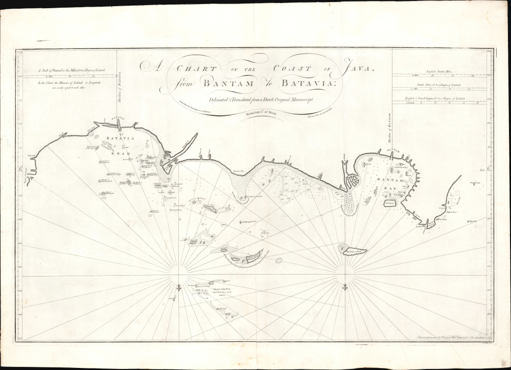
A Chart of the Coast of Java from Bantam to Batavia.
1777 (dated) 20.25 x 33 in (51.435 x 83.82 cm) 1 : 220000
1777 (dated) 20.25 x 33 in (51.435 x 83.82 cm) 1 : 220000
Description
This is William Herbert's rare 1777 nautical map of northern Java in the vicinity of Jakarta (Batavia and Bantam). The chart was issued for the 1777 fourth edition of Herbert's New Directory for the East Indies, published by his protégé Henry Gregory as an English response to Jean-Baptiste de Mannevillette's 1775 reissue of the Neptune Oriental.
This chart formed the definitive basis for English charts of Batavia throughout the 18th and into the 19th century, mainly through the auspices of Laurie and Whittle. Their chart - A New Chart of the North Coast of Java, wherein are described The Roads of Bantam and Batavia, from the Manuscript Draught of the Dutch East India Company - is a rote copy of the present work despite being reoriented to the north.
A Closer Look
This large southward-oriented nautical chart embraces the northern Java coastline from Bantam Bay to the Batavia Road, a region today largely subsumed into metropolitan and suburban Jakarta, Indonesia. The chart includes anchorages, soundings, and notations of navigational hazards. While the calligraphy, typography, and spartan format are stylistically English, the execution of the coastline evokes the chart's unnamed Dutch source.Manuscript Source
In preparing his response to Mannevillette's sea atlas, Herbert amassed a commanding collection of manuscript plans and charts of East India ports and coastlines. Although a great many of Herbert's charts were derived from Mannevillette, this chart was 'Delineated and Translated from a Dutch Original Manuscript.' The specific manuscript source has proven elusive; however, surviving Dutch manuscript charts in the Bibliothèque Nationale by Joan Blaeu (1596 - 1673) and in the Dutch National Archives by Isaac de Graaff (1668 - 1743) suggest that this map conforms to Dutch conventions in mapping the Batavia Road.This chart formed the definitive basis for English charts of Batavia throughout the 18th and into the 19th century, mainly through the auspices of Laurie and Whittle. Their chart - A New Chart of the North Coast of Java, wherein are described The Roads of Bantam and Batavia, from the Manuscript Draught of the Dutch East India Company - is a rote copy of the present work despite being reoriented to the north.
Publication History and Census
This chart was published by Henry Gregory in his much-expanded editions of William Herbert's New Directory for the East Indies. We see no earlier examples of the separate chart under Herbert's own imprint and no earlier states. We see no auction records of the chart since 2006. Only two examples of the chart - one of this edition, and one printed in 1789 by Gregory's successor William Gilbert - are recorded in institutional collections.CartographerS
William Herbert (November 29, 1718 – March 18, 1795) was a British map seller, book seller, publisher, and surveyor based in London in the second half of the 18th century. Herbert was born in London, the son of a dyer and hosier of Gravel Lane. He signed on to the East India company in 1738 as a purser's clerk, traveling in the process to the colonies in India. He returned to London in about 1745, having amassed a considerable collection of manuscript plans and charts of East India ports. Recognizing their commercial value, he set up business as a map and print seller on London Bridge in 1748. The premises of this business were sadly destroyed while Herbed watched the April 11, 1759 London Fire. He published a number of maps as well as the important New Directory for the East Indies. Much of his most important cartographic work seem to be associated with William Nichelson, who traveled to the East Indies in the 1750s and 60s mapping ports on behalf of the EOC. He retired in 1776 in reasonable comfort. His publications continued to be updated and re-published by his successors, among them Samuel Dunn and Henry Gregory. More by this mapmaker...
Henry Gregory (1744 - c. 1811) was an English chart and instrument maker active in London. Gregory was born in England. Gregory was apprenticed to John Fowler in 1732. He was in business for himself from c. 1750, operating 'The Azimuth Compass' in Leadenhall Street, London. He was a protégé of William Herbert (1718 – 1795) whose chart stock he took over in 1776. As a chartmaker, he produced the 1769 Directions for navigating from the Channel to the East Indies and the 1774 An Account of the Constant and Periodical Trade-Winds: or Monsoons, the Land and Sea Breezes. He collaborated with Samuel Dunn (1723 - 1794) on the 1775 Navigator's guide to the Oriental or Indian Seas. That same year, he took over the publication of Herbert's New Directory for the East Indies. Among the many instruments he produced, his azimuth compasses received praise from no lesser light than explorer James Cook (1728 - 1779) and were used in numerous late 18th century British voyages of exploration. Henry Gregory partnered with Gabriel Wright, operating as 'Gregory and Wright' from in 1782 - 1790, based at Navigation Warehouse, 148 Leadenhall Street, London (Gloria Clifton, G. Directory of British Scientific Instrument Makers, 1550 - 1851). Learn More...
Source
Herbert, W., New Directory for the East Indies, (London: Gregory) 1777.
Condition
Very good. Mended splits at top and bottom centerfold.
References
OCLC 7457294.