This item has been sold, but you can get on the Waitlist to be notified if another example becomes available, or purchase a digital scan.
1708 Herman Moll Map of Barbados
Barbados-moll-1708$112.50

Title
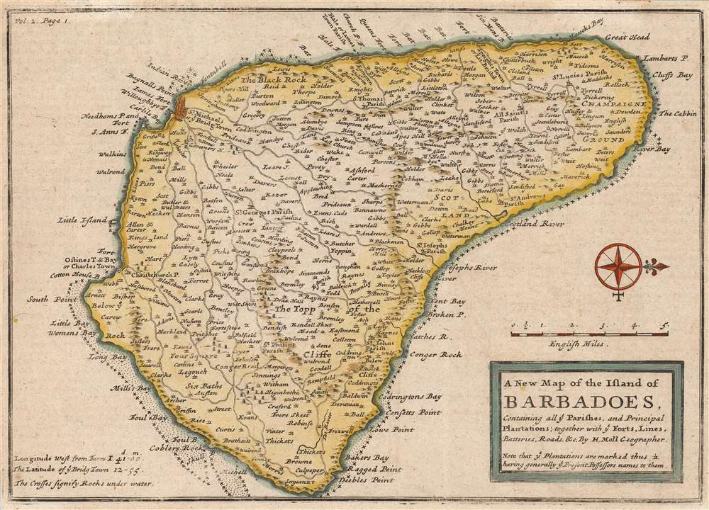
The New Map of the Island of Barbadoes, Containing all ye Parishes, and Principal Plantations; together with ye Forts, Lines, Batteries, Roads etc. By H. Moll Geographer.
1708 (undated) 7 x 10 in (17.78 x 25.4 cm) 1 : 149000
1708 (undated) 7 x 10 in (17.78 x 25.4 cm) 1 : 149000
Description
This is a 1708 Herman Moll map of the island of Barbados. The map depicts the entire island oriented to the west, with the elegant compass rose indicating north to the right. The island is divided into its eleven parishes, all as today with the exception of St. Peter, which is here named 'All Saints'. The map names the island's towns, among which the island's capital at Bridge Town is emphasized. Much more in evidence are the island's many individual plantations, labeled with the owner's last name. Parish churches are noted as well. The map also illustrates roads and waterways. Topography is depicted pictorially. A scale is provided in English miles.
Publication History and Census
This map was drawn by Herman Moll and printed in 1708 by John Nicholson for inclusion in the second volume of John Oldmixon's The British Empire in America. Oldmixon's work is well represented in institutional collections, and the map appears on the market from time to time, both in this edition and reprints from 1717, 1732 and 1741.Cartographer
Herman Moll (1654 - 1732) was an important 18th century map publisher and engraver based in London and Holland. Moll's origins are disputed with some suggesting he was born in the Netherlands and others Germany - the Moll name was common in both countries during this period. Most likely Moll was a German from Bremen, as his will, friends, and contemporaries suggest. What is known for certain is that he moved to London in 1678, possibly fleeing the Scanian War, where he worked as an engraver for Moses Pitt and other London map publishers. Around the turn of the century, Moll set up his own shop where he produced a large corpus of work known for its high quality and decorative flair. As a new émigré to England, Moll made himself more English than the English, and through his cartography proved a fierce advocate for his adopted nation. Most of Moll's early maps were issued as loose sheets that would be bound to order, however, he did publish several important atlases late in his career. Moll is said to have made the bold claim that without a doubt "California is an Island" and that he "had in [his] office mariners who have sailed round it." While California may not be an island (yet), it is true that moll had talent for attracting interesting friends and acquaintances. He frequented London's first stock exchange, Jonathan's Coffeehouse at Number 20 Exchange Alley, Cornhill. At the time Jonathan's was known as "a place of very considerable concourse for Merchants, sea faring Men and other traders" (Erleigh, The Viscount, The South Sea Bubble, Manchester: Peter Davies, Ltd., 1933, 21). Eventually this activity attracted the interest of stock brokers, who inspired by sailor's tales, sponsored the ill-fated South Sea Company, the world's first stock bubble. Moll's close circle, mostly from the Coffee House, included scientist Robert Hooke, the writers Daniel Defoe (Robinson Crusoe) and Jonathan Swift (Gulliver's Travels), the pirates William Dampier, William Hacke and Woodes Rogers, and the archeologist William Stukeley. Herman Moll's work was highly regarded for its decorative beauty and was pirated, most notably by the Irish publisher George Grierson, both in his lifetime and after his 1732 death at St. Clement Danes, London. More by this mapmaker...
Source
Nicholson, J.. The British Empire in America, Volume II, (London), 1708.
Condition
Very good. Original folds visible. Blank on verso.
References
OCLC 494214018.