1927 British Admiralty Nautical Map of Barbados
Barbardos-admiralty-1927$850.00

Title
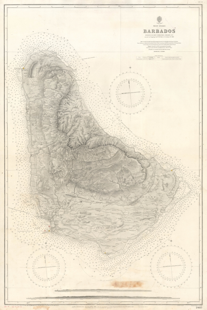
West Indies Barbados.
1927 (dated) 38.5 x 26.25 in (97.79 x 66.675 cm) 1 : 48000
1927 (dated) 38.5 x 26.25 in (97.79 x 66.675 cm) 1 : 48000
Description
An impressive 1927 British Admiralty nautical chart of Barbados, with manuscript updates to 1937.
A Closer Look
The chart features a wealth of information, both of a terrestrial and nautical nature. It names churches, private estates, roads, schools, and more. Of interest, most hill tops are marked with the symbol of a circle with an 'x' over it, the standard Admiralty demarcation for a windmill. Most of these would have powered sugar mills, the island's primary export under British rule. Some of these historic windmills still stand.Publication History and Census
This chart was originally published in 1873. It was engraved by Davies and Company for the British Admiralty. The chart exhibits major corrections to February 1876, and minor corrections to 1927. There are additional manuscript corrections to 1937.CartographerS
The British Admiralty Office (1795 - Present) or the United Kingdom Hydrographic Office refers to the Branch of the English government that is responsible for the command of the British Navy. In 1795 King George III created the United Kingdom Hydrographic Office, known in short as the U.K.H.O., to provide top notch nautical charts to the vast Royal Navy. Prior the founding of the Admiralty the surveying and creation of nautical charts was primarily a commercial venture wherein the cartographer himself, more of than not, actually financed the printing of his own material. The great navigator Cook himself is known to have scrambled for funds to publish his own seminal charts - the most important and advanced of the period. The system of privately funded nautical mapping and publishing left vast portions of the world uncharted and many excellent charts unpublished. King George III, responding significant loss in trade revenue related to shipwrecks and delay due to poor charts, recognized the need for an institutionalized government sponsored cartographic agency - the Admiralty. The first head of the Admiralty, a position known as Hydrographer, was the important cartographer Alexander Dalrymple. Dalrymple started by organizing and cataloging obtainable charts before initiating the laborious process of updating them and filling in the blanks. The first official Admiralty Chart appeared in 1800 and detailed Quiberon Bay in Brittany. By 1808 the position of Hydrographer fell to Captain Thomas Hurd. Hurd advocated the sale of Admiralty charts to the general public and, by the time he retired in 1829, had issued and published some 736 charts. Stewardship of the organization then passed to Rear Admiral Sir Francis Beaufort. It was under Beaufort's administration that the Admiralty truly developed as a "chart making" as opposed to a "chart cataloging" institution. Beaufort held his post from 1829 to 1854. In his 25 years at the Admiralty Beaufort created nearly 1500 new charts and sponsored countless surveying and scientific expeditions - including the 1831 to 1836 voyage of the H.M.S. Beagle. By 1855 the Admiralty's chart catalog listed some 1,981 charts. More by this mapmaker...
Davies and Company (fl. c. 1880 - 1930) was an engraving and lithography firm active in London during the late 19th century. The firm engraved nautical charts for the British Admiralty Hydrographic offices in the 1880s to the early 1920s. The firm may be the successor of Davies, Bryer, and Company (fl. 1866 - 1872), who also worked with the Admiralty, which dissolved in 1872. It may also be related to the firm of Robert Davies, Maddock, and Company, which was dissolved in 1905. Their imprint, as Davies and Company, appears as early as 1880 and as late as the 1920s, but the firm may have closed its doors by that point and the imprints persist on map plates only as a legacy. Learn More...
Condition
Good. Discoloration bottom center.
References
OCLC 297115415.