1867 Hughes Map of the Barbary Coast or Northern Africa in Antiquity
Barbary-hughes-1867$100.00

Title
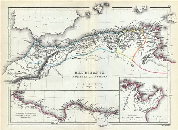
Mauritania Numidia and Africa.
1867 (undated) 10 x 13 in (25.4 x 33.02 cm) 1 : 6750000
1867 (undated) 10 x 13 in (25.4 x 33.02 cm) 1 : 6750000
Description
This is a beautiful 1867 map of the Barbary Coast or northern Africa in antiquity by William Hughes. The map depicts the ancient empires of Mauritania, Carthage and Numidia or what is today the Barbary Coast. It covers from the Atlas Mountains on the western coast of modern day Morocco, east as far as modern day Tunisia. An inset map along the bottom border (Continuation of the African Coast from the Syrtis Minor to Egyot), covers from Tunisia eastward as far as Egypt. Another inset in the lower right quadrant features an enlarged plan of the Carthaginian Territory.
The Carthaginian Empire was formed after Carthage (identified here) gained independence from the Phoenician colonies in 650 BC. Carthage became the center for trade the Carthaginian Empire dominated much of the region, until Numidia, the Kingdom to the west of Carthage, allied itself with Rome in 206 BC leading the Roman conquest of the region in 201 BC. By the end of the third Punic war, the city of Carthage was leveled by Rome, thus ending its independent existence. Carthage's great general Hannibal, nearly conquered Rome with his highly trained war elephants, before being turned back at the very brink of victory. Still further west, the Kingdom of Mauretania was established as the Roman Province of Mauretania Casariensis.
This map was created by William Hughes, printed by J. Bien and engraved by G.E. Sherman, for issued as plate 23 in Sheldon and Company's An Atlas of Classical Geography.
CartographerS
William Hughes (c. 1818 - May 21, 1876) was a cartographer, engraver, lithographer, printer, and publisher active in London during the middle part of the 19th century. Hughes enjoyed and long and varied cartographic career. He was elected a Fellow of the Royal Geographical Society in 1838 and, from about 1840, taught geography and mapmaking at St. Johns College for Civil Engineers. He later taught the same at both Queens College and Kings College, London. For a time he was employed as a map librarian for the British Museum. Hughes began engraving maps around 1839 and worked with most of the prominent British map and atlas publishers of his era, including but not limited to Charles Knight, A. and C. Black, George Philip, William Cassell, and others. More by this mapmaker...
Julius (Julien) Bien (September 27, 1826 - December 21, 1909) was a German-Jewish lithographer and engraver based in New York City. Bien was born in Naumburg, Germany. He was educated at the Academy of Fine Arts, Cassell and at Städel's Institute, Frankfurt-am-Main. Following the suppression of the anti-autocratic German Revolutions of 1848, Bien, who participated in the pan-German movement, found himself out of favor in his home country and joined the mass German immigration to the United States. Bien can be found in New York as early as 1849. He established the New York Lithographing, Engraving & Printing Company in New York that focused on the emergent chromo-lithograph process - a method of printing color using lithographic plates. His work drew the attention of the U.S. Government Printing Office which contracted him to produce countless government maps and surveys, including the Pacific Railroad Surveys, the census, numerous coast surveys, and various maps relating to the American Civil War. Bien also issued several atlases both privately and in conjunction with a relation, Joseph Bien. At the height of his career Bien was elected president of the American Lithographers Association. After his death in 1909, Bien's firm was taken over by his son who promptly ran it into insolvency. The firm was sold to Sheldon Franklin, who, as part of the deal, retained the right to publish under the Julius Bien imprint. In addition to his work as a printer, Bien was active in the New York German Jewish community. He was director of the New York Hebrew Technical Institute, the New York Hebrew Orphan Asylum, and president of the B'nai B'rith Order. Learn More...
Sherman and Smith (fl. c. 1829 - 1855), sometimes working as Stiles, Sherman & Smith, were American engravers active in New York City during the middle part of the 19th century. The firm including John Calvin Smith (surveyor and engraver), George E. Sherman, and sometimes, Samuel Stiles. Their work primarily focused on government publications, including the maps and engravings prepared to illustrate the official records of the 1838-42 United States Exploring Expedition (U.S. Ex. Ex.), maps issued for the Army Corps of Topographical Engineers, and various U.S. Coast Survey Charts. They also engraved privately for Thomas Bradford and John Disturnell, among others. Sherman and Smith maintained offices at the corner of Broadway and Liberty Street in New York City and were highly regarded as the finest cartographic engravers in the city. Their non-cartographic legacies include George Inness, who apprenticed with them for two years before going on to become a well regarding American landscape painter of the Hudson River School. Learn More...
Source
Sheldon and Company, An Atlas of Classical Geography constructed by William Hughes and edited by George Long, (New York) 1867.
Condition
Very good. Minor wear and toning along original centerfold.