This item has been sold, but you can get on the Waitlist to be notified if another example becomes available, or purchase a digital scan.
1886 Direccion de Hidrografia Nautical Map of the Basilan Strait, Philippines
BasilanPhilippines-direccionhidrografia-1887$750.00


Title
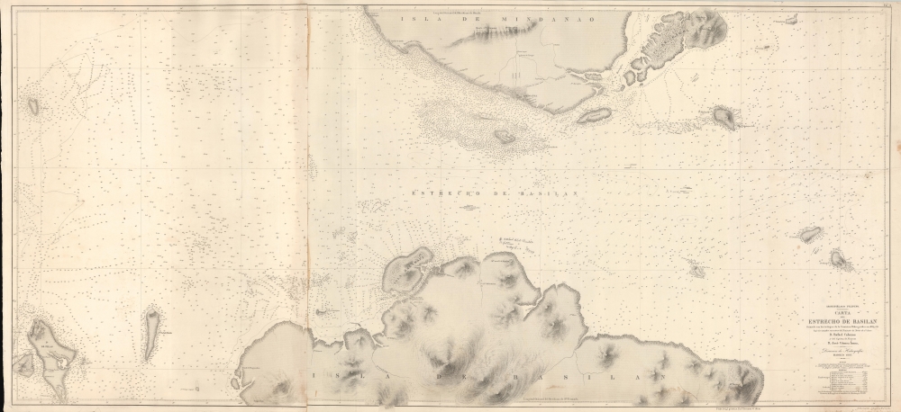
Archipiélago Filipino. Carta del Estrecho de Basilan.
1887 (dated) 26.5 x 58 in (67.31 x 147.32 cm) 1 : 68580
1887 (dated) 26.5 x 58 in (67.31 x 147.32 cm) 1 : 68580
Description
A rare 1886 nautical map of the Basilan Strait, Sulu Sea, Mindanano, Philippines. The strait was (and remains) a critical passage through the Sulu Archipelago and major access point to the Moro Gulf, southern Mindanano, and the trans-Pacific passage.
A Closer Look
Coverage embraces the southern tip of Mindanao, known as the Zamboanga Peninsula, the northern tip of the island of Basilan, and the strait between, being the most viable deep-water pirate-safe channel between the Sulu Sea and the Moro Gulf. The chart is the result of fresh surveys by Spanish hydrographers Rafael Cabezas and José Gómez Ímaz, conducted as Zamboanga became a staging point for Spanish Campaigns ageist the Moro. Soundings are particularly dense around the Spanish forts at Zamboanga and Isabela.The Moro Wars
This map was issued against the backdrop of the 1886-87 Moro Wars campaigns against the Rio Grande Moros. The Basilan Strait was uniquely and strategically located at the crossroads of three empires, the Spanish to the north, the Moros Sultanates of Sulu to the South and Maguidanano to the east. The Spanish were at war with both, mostly due to their Muslim faith and dogged resistance to Catholic conversion. Control of the strait, which represented the most viable naval passage between the Sulu Sea and the Moro Gulf, was fortified on both size by the Spanish, on Mindanao in Zamboanga, and in Basilan at Fort Isabela. Zamboanga was a critical Spanish staging point for troops headed both east against the Maguidanano and south against the Sulu. Ultimately the Spanish never fully suppressed the Moros. The Spanish-Moro conflict (La Guerra Español y Moro) persisted for some 330 years, only coming to an end when the American takeover at the end the Spanish-American War (April 21 - August 13, 1898). Later, the Americans had their own war with the Moros (1899 - 1913).Publication History and Census
This chart was published by the Direccion de Hidrografia, in Madrid, in 1887. The chart was engraved by Estaban Perez y Martínez, with Salvador Bregante y Martínez engraving the text. There are earlier charts of the same title, but this chart is the result of We see examples at the Biblioteca Nacional de Españ, Biblioteca Virtual del Ministerio de Defensa. Rare.CartographerS
The Direccion Hidrografía (1787 - 1927), also known as the Deposito Hydrografico and the Direction de Hidrografía, was the Spanish equivalent of the British Admiralty or the U.S. Coast Survey. This organization, founded in 1787, was commissioned to collect and produce accurate nautical charts of all waters frequented by Spanish vessels. In essence, it replaced the Casa de la Contratación de las Indias (House of Trade of the Indies), which closed its doors in 1790. Like most such organizations, the Direccion Hidrografía marked a new age in cartography. Rather than simply collect charts created by navigators, explorers, and merchants, the Direccion Hidrografía worked closely with naval and military personnel to mount cartographic and hydrographic expeditions in pursuit of the most accurate hydrographical, astronomical, and geodetic measurements. The Direccion Hidrografía created a massive library of nautical charts that, though not nearly as common as similar nautical charts by the U.S. Coast Survey and British Admiralty, are highly desirable for the beauty of their manufacture as well as their accuracy and detail. The office was originally located on Calle Ballesta, but relocated to 36 Alcala, both in Madrid. After 1908 the Dirección was subsumed into other governmental agencies. In 1927 the Direccion was absorbed into the Institute and Observatory of San Fernando, located in Cadiz. The library of original maps, charts, and journals was transferred to the Naval Museum of Madrid - where it resides to this day. More by this mapmaker...
Perez, E. Perez y (fl. c. 1864 - 1908) was an engraver with the Spanish Dirección General de Hidrografía most active in the second half of the 19th century. Despite contributing to more than 150 maps, nothing is known of his life, not even his given name. Learn More...
Salvador Bregante y Orbay (fl. 1840 - 1890) was a Spanish engraver and draftsman active with the Dirección Hidrografía in the middle part of the 19th century. A relative, Francisco Bregante y Orbay (fl. 1840 - 1867), also worked for the Dirección Hidrografía in a related capacity. Learn More...
Condition
Good. Some soiling. Glue discoloration where sheets were originally joined. A few minor closed and reinforced tears.
References
Biblioteca Nacional España, MR/22 H. 147 A. OCLC 1312297527.