This item has been sold, but you can get on the Waitlist to be notified if another example becomes available, or purchase a digital scan.
1941 Mercier Map of the East Indies Before the Japanese Onslaught of 1941
BataillesIles-mercier-1941$475.00

Title
Entre le Pacifique et l'Océan Indien La Bataille des Iles
1941 (undated) 16.25 x 22.75 in (41.275 x 57.785 cm) 1 : 10588000
1941 (undated) 16.25 x 22.75 in (41.275 x 57.785 cm) 1 : 10588000
Description
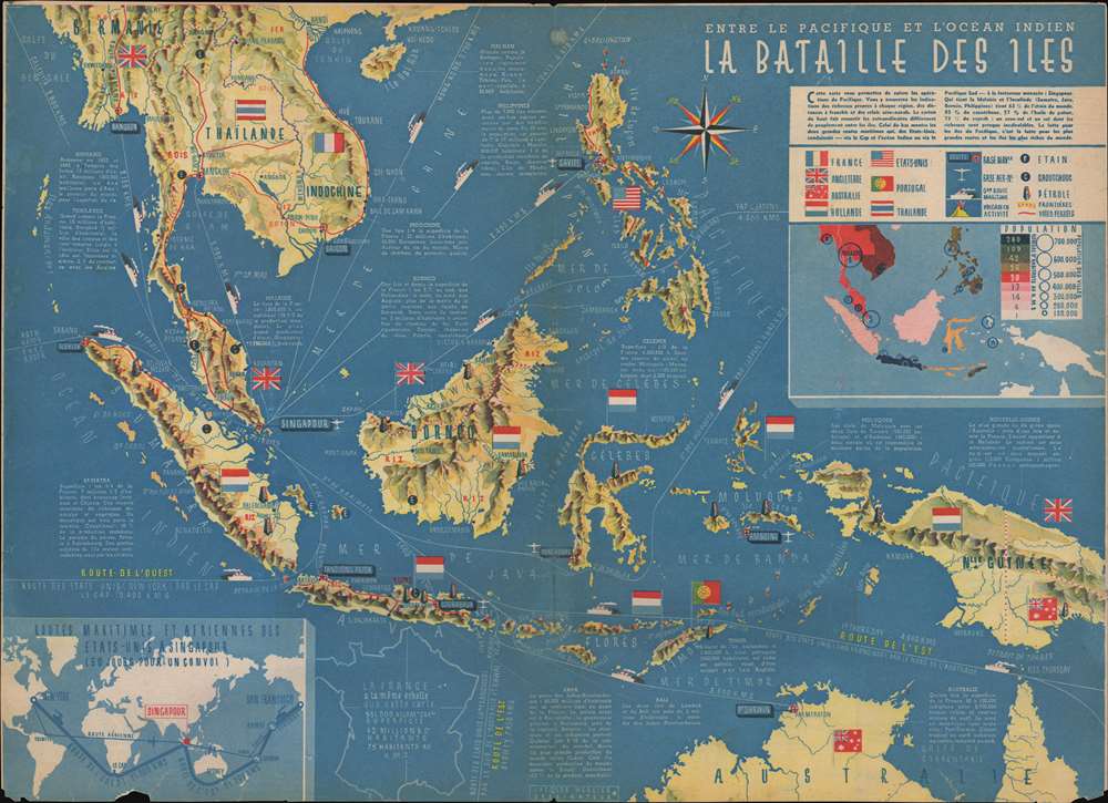
This is a c. 1941 Jacques Mercier map of the East Indies before the Japanese offensives of late 1941. By using the flags of the colonial powers in the region, Mercier renders is immediately apparent that only Thailand is governed by the people that live there. Everywhere else in the region is controlled by the Americans, British, French, Dutch, or Portuguese. Short commentaries on each island or colony are included, informing the viewer of each location's population and economic output. Many of these exports, such as rice, cotton, tobacco, and wood, are printed in the corresponding locations in red ink. Tin, rubber, and oil deposits are marked by symbols. Another symbol is used to mark active volcanoes. The thick red lines printed on the map represent the region's railroads, which had been constructed in Malaysia, Thailand, Indochina, the Philippines, and Java. International trade routes are illustrated as well, with distances to the United States given in kilometers. An inset map, situated in the upper right corner below the legend provides an overview of population density of the islands and countries in the region, while a second inset map, expands the network of air and sea routes to Singapore across the world.
How We Dated This Map
There is no printed date on either the recto or verso of this piece. When looking at the data presented on the map itself, it become evident that the map was created during World War II, but no definitive information is provided to allow for a definitive date. An article printed on the verso makes reference to the fact that the Japanese invasion of the Philippines had already commenced by the time this piece was published, meaning that it must have been printed sometime after the Japanese invasion began on December 8, 1941 but before the final American surrender on May 8, 1942.Publication History and Census
This map was created by Jacques Mercier and published in an unknown French magazine c. 1941. It is important to note that by 1941 France had been divided into an Occupied Zone operated by Nazi Germany, and an Unoccupied Zone, governed by Maréchal Philippe Pétain and his regime at Vichy, meaning that this map was likely produced under difficult circumstances. We have been unable to locate any reliable information concerning the printer, the Imprimerie E. Desfossés-Néogravure, identified on the verso, which also includes a reference to St-Fons, a small town in southeastern France. We have been unable to uncover any information about a printer going by that name in that city. An Imprimerie E. Desfossés-Néogravure operated in Paris both before and after the war, so it is possible that they are the same company, but there is no way of knowing for sure. We have also been unable to locate any other known examples.Condition
Good. Newsprint. Closed margin tears professionally repaired on verso. Exhibits slight loss along bottom border. Wear along original centerfold. Verso reinforcements along original centerfold and closed tears emanating from centerfold professionally repaired on verso. Text on verso.