This item has been sold, but you can get on the Waitlist to be notified if another example becomes available, or purchase a digital scan.
1799 Clement Cruttwell Map of Holland or the Netherlands
Batavia-cruttwell-1799$75.00

Title
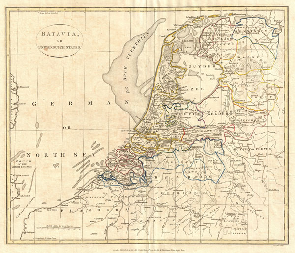
Batavia or United Dutch States.
1799 (dated) 14 x 16.5 in (35.56 x 41.91 cm)
1799 (dated) 14 x 16.5 in (35.56 x 41.91 cm)
Description
A fine 1799 map of Batavia or the United Dutch States (the Netherlands) by the English map publisher Clement Cruttwell. Map is highly detailed, with counties and municipalities outlined. Of note on this particular map are the canals and dikes Cruttwell labeled. These are extremely important to the country, as two thirds of the land is vulnerable to flooding. River dikes prevent flooding from water flowing into the country by the major rivers Rhine and Meuse, while a system of drainage ditches, canals and pumping stations (windmills) keep the low lying parts dry for habitation and agriculture. The Beemster, as Cruttwell notes in Northern Holland, was the first of these and was reclaimed from a lake, the water having been extracted by windmills. He also labels what is known as the De Breeveertien (De Bree Veerthien) a large offshore shoal in the North Sea now home to an important wind farm. In North Holland he identifies Zuyder Zee, which at this point in time was a shallow bay in the North Sea. In the 20th century the majority of the Zuyder Zee was closed off and the salt water inlet changed into a fresh water lake called the Ijsselmeer (IJssel-lake), named thus after the river that drains into it. The whole offers hand color and fine copper plate engraving in the minimalist English style prevalent in the late 18th and early 19th centuries. Drawn by G. G. and J. Robinson of Paternoster Row, London, for Clement Cruttwell's 1799 Atlas to Cruttwell's Gazetteer.
Cartographer
Clement Cruttwell (1743 - August 5, 1808) was an English book and map publisher active in Bath and London in the late 18th and early 19th century. Cruttwell was born the son of William Cruttwell, a gentleman of Wokingham, Berkshire, England. As a young man Cruttwell was educated to be an Anglican Reverend and consequently maintained a lifelong interest in religious matters. Throughout his life, he published a number of religious works and geographical gazetteers including several focused on the British Isles and one dedicated to France. Though little is known of Cruttwell today, he was highly regarded in his own time. In his obituary, a period publication, The Universal Magazine of Knowledge and Pleasure describes Cruttwell as
a gentleman whose various literary performances, for labour, extent, and utility, have rarely been equaled, and, when regarded as the productions of an unassisted valetudinarian, have perhaps never been surpassed.Cruttwell was also a known correspondent of George Washington to whom he sent his own translation of the Holy Bible, which Washington kept in his personal library until his death. More by this mapmaker...
Source
Cruttwell, C., Atlas to Cruttwell's Gazetteer, 1799.
Condition
Very good. Original centerfold. Platemark visible. Some offsetting. Moderate overall toning. Blank on verso.