
1873 Roe and Colby Wall Map of Bath, Maine

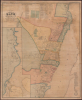
Map of the City of Bath Sagadahoc Co. Maine.
Powerhouse of American Shipbuilding.
- Digital Map Information
- Suitable for large format printing
- Full resolution TIFF file
- ICC color profile embedded
- Delivered instantly via download link
Powerhouse of American Shipbuilding.
This is a scarce 1873 wall map of Bath, Maine, prepared by local cartographers Frederick B. Roe and George N. Colby. The map is notable for documenting the city's importance as a center of the American shipbuilding industry.A Closer Look
The map presents Bath, situated along the Kennebec River, with color-shading distinguishing the city's wards. Most of Ward 1, south of the main part of the city, appears in an inset at left. Streets are labeled throughout, and individual property lines are traced with owners indicated. Public institutions such as schools, charitable organizations, parks, churches, cemeteries, court houses, and a customs house are shaded green. All along the river are wharves and shipyards, the largest being widely recognized in their time as the premier American shipbuilding firms. Unsurprisingly, the owners of these firms, such as William D. and Arthur Sewall, also held considerable amounts of property throughout the city. Operations associated with the shipbuilding industry, such as lumber mills at bottom-left and brickyards, are also indicated. A business directory broken out by industry appears at top, continued at bottom-left.Bath Shipyards
During the mid-to-late 19th century, Bath, Maine, earned its nickname as the 'City of Ships,' emerging as a premier maritime powerhouse that produced nearly half of all wooden sailing vessels built in the United States. Following the shipbuilding boom of the 1850s, where the city ranked as the nation's fifth-largest port, Bath's shipyards displayed remarkable resilience despite the trade disruptions of the American Civil War (1861 - 1865). Renowned shipbuilder families like the Sewalls and Houghtons directed a massive workforce to construct 'Down Easters,' deep-water square-riggers known for their speed and cargo capacity, which dominated the global grain and guano trades. At its peak, the banks of the Kennebec River were lined with over 20 active shipyards, their launchways bustling with the construction of massive wooden schooners designed to haul coal and timber up and down the Atlantic coast.As the century drew to a close, Bath underwent a critical industrial transformation that bridged the gap between the age of sail and the age of steam. While the city continued to push the boundaries of wooden ship size, exemplified by the massive multi-masted schooners built by Percy and Small (culminating in the six-masted Wyoming in 1909, the largest wooden ship ever built), it also pioneered the transition to steel. In 1884, local Civil War veteran General Thomas W. Hyde founded Bath Iron Works, shifting the local focus toward marine engineering and metal fabrication. By the 1890s, Bath Iron Works had secured contracts for the U.S. Navy's first steel gunboats, while the Arthur Sewall shipyard launched the nation's first steel sailing vessels, effectively securing Bath's legacy as a center of naval innovation well into the modern era.
Publication History and Census
This map was prepared by Frederick B. Roe and George N. Colby, engraved by George Worley and William Bracher, and printed by Frederick Bourquin, all of Philadelphia, in 1873. This wall map is very rare, only being noted among the holdings of the University of Southern Maine, the University of Maine at Orono, and the Patten Free Library, with no recent market history.Cartographers
George Nehemiah Colby (January 13, 1846 - 1890) was an American civil engineer and map publisher active in Houlton, Maine in the late 19th century. Colby was born in South Berwick Maine and was married to Julie Gertrude Ganong (1853 – 1889). Colby's corpus of work consists primarily of Maine focused wall maps, county and state atlases, and more specific regional maps, for which he personally compiled surveys and sold by subscription. Colby initially worked with the U.S. Coast Survey, where his work contributed to the survey's important 1881 map of Mount Desert Island, Maine. In the private market Colby published Maine centered material in the style of Massachusetts cartographer Henry Walling. That is to say, he issued highly detailed maps on a large scale that he sold by subscription to local institutions and land owners. Colby's maps, like Walling's, are exceptionally desirable for anyone interested in family history, as they often list individual family names and land holdings. Colby pwartnered Frederick B. Roe in 1873 to issue wall maps of several Maine towns including New Brunswick, Thomaston, Bath, and Camden. This partnership lasted until about 1878 and maintained offices in Philadelphia at 31 South 6th Street. Colby later partnered with Joseph Harry Stuart (1855 - 183?) to similarly publish subscription-based maps and atlases of Maine counties and communities. When Colby retired in the 1890s, Stuart fully took over his business, continuing to publish as J. N Stuart into the 1930s. Colby and his wife had three children, George Nehemiah, Frederik Franklin, and Mary Gertrude. Further Details...
Frederick B. Roe (1845 – April, 1905) was an American civil engineer and map publisher. Roe was born in Brookfield, Connecticut. Roe was of a generation of cartographers, along with Henry Walling, Frederick Beers, George Colby, J. N Stuart, and others who, taking advantage of the lithography printing revolution, traveled throughout the United States mapping and publishing large scale town and county maps. These were generally sold by subscription and were often printed only in very small runs. Roe seems to have been primarily based in Philadelphia, which was then an important map printing center, but he traveled extensively. He also lived for a time in Reading Pennsylvania, where he served a term on the Common Council. He also lived for a time in Wilmington, Delaware, where he lived while working on a detailed wall map of that region. Roe partnered with George N. Colby in 1873 to issue wall maps of several towns in Maine including New Brunswick, Thomaston, Bath, and Camden. This partnership lasted until about 1878 and maintained offices in Philadelphia at 31 South 6th Street. Later he moved his offices to 17 North 6th Street, Philadelphia. Among his more important works is a detail city plan of Duluth, Minnesota, published with Albertson and Chamberlain. He died in Cincinnati in the last week of April, 1905. Further Details...
George Worley (c. 1819 - November 21, 1879) was an English lithographer active in Philadelphia. Born in England, Worley lived in Philadelphia by 1843 where he worked as an artist. He worked as a lithographer for Robert Pearsall Smith in his map publishing establishment from c. 1856 - 1859. In 1858 or 1859, Worley became a partner in the firm Worley, Bracher, and Matthias with William Bracher (1827 - 1912) and Benjamin Matthias. Worley, Bratcher, and Matthias lasted until 1860 when Matthais left. After Matthias's departure, Worley and Bracher renamed the firm Worley and Bracher and remained in operation until 1879, during which time they produced over 200 maps and atlases. Worley married Ann Thakeray on March 14, 1841 and died of liver disease. Further Details...
William Bracher (June 29, 1829 - May 14, 1912) was a Philadelphia based engraver and lithographer active in the late 19th century. Bracher was born in Göppingen, Badan-Württemberg, Germany. He was a 48er, who emigrated to the United States in 1848 with his wife Amelia A. M. Bracher (born Naigele), fleeing the failed Springtime of the Peoples Revolutions (1848 - 1849). He settled in Philadelphia, where he established himself as line and stipple engraver as early as 1861. He was naturalized as a U.S. citizen on March 27, 1854. Around 1858, Bracher partnered with George Worley and Benjamin Matthais to from the printing firm of 'Worley, Bracher and Matthias'. They were active at 600-602 Chestnut Street, Philadelphia, until 1860, when Matthias left the firm. At this time, the firm was renamed 'Worley and Bracher'. In 1866, they relocated to 104 Hudson Street (rear 320 Chestnut Street) and remained until 1873. From 1873 to 1875, the firm rented at 31 South Sixth Street and then at 27 South Sixth Street until 1891. The firm appears to have shared space and often worked with a variety of private Philadelphia engravers, including Frederick Bourquin (1808 - 1897), William Hart, James McGuigan, F. C. Paxson, Henry J. Toudy (fl. c. 1857 - c. 1877), and Thomas S. Wagner. Further Details...
Frederick Bourquin (1808 - 1897), also spelled Bourgin, was a Swiss American engraver and lithographer active in Philadelphia in the mid- to late-19th century. Bourquin was born in Bern, Switzerland, and emigrated to the United States in 1817 accompanied by his brother, Charles F. Bourquin, also an engraver. They lived briefly in Bucks County, Pennsylvania, and New York City, before relocating to Philadelphia in 1829 to join the lithographic firm of Kennedy and Lucas. Bourquin was naturalized as a U.S. citizen in 1834. From 1842 the brothers worked for Peter Stephen Duval (1804/5 - 1886) at 'P. S. Duval and Co.' They became partners in the firm in 1857. In 1858, Frederick left Duval to partner with Robert Pearsall Smith (1827 - 1898), one of the lead publishers in the Philadelphia-based county map and state atlas industry, publishing as 'F. Bourquin and Company' (602 Chestnut Street). Smith completely and inexplicably retired from publishing around 1865, leaving the business to Bourquin. Subsequently Bourquin shared premises and often published with William Bracher's (1829 - 1912) firm, 'Worley and Bracher'. In the mid-1850s Bourquin relocated to Camden, New Jersey, where he served on the City Council from the 1870s - 1880s and in the New Jersey State legislature in 1872. His sons, Frederick Bourquin, Jr., Gordon M. Bourquin, David L. Bourquin, and Charles L. Bourquin, were all, to a greater or lesser extent, involved in the lithographic and/or printing business. Further Details...
Condition
Good. Full professional restoration. Mounted on fresh linen. Cracking. Some areas of infill to upper margin and border.
References
OCLC 268965885. Patten Free Library Patten Sagadahoc Rm MAINE MAP Boardroom.