1895 U.S. Coast Survey Nautical Chart / Map of New York City Harbor
BayHarborNewYork-uscs-1895$500.00

Title
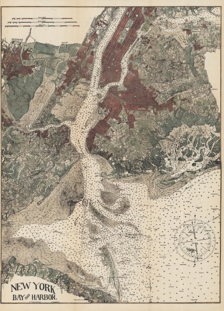
New York Bay and Harbor.
1895 (undated) 23.25 x 17.75 in (59.055 x 45.085 cm) 1 : 90000
1895 (undated) 23.25 x 17.75 in (59.055 x 45.085 cm) 1 : 90000
Description
A curious and detailed c. 1895 nautical chart of the waters around New York City. Its production is rather mysterious; though clearly based on work by the U.S. Coast Survey, it looks to be a modified and likely unauthorized reprint.
Superb detail is present throughout, with city blocks, important buildings, farms and fields, river ways, streams, swamps, and topographical features noted. In addition to inland detail, this chart contains a wealth of practical information for the mariner from depth soundings, to notes on harbors, navigation tips about important channels, tables detailing light houses and beacons, tides, and magnetic declination.
A Closer Look
Much of New York City as we know it today is illustrated here, including Manhattan, Queens, Brooklyn, the South Bronx, and part of Staten Island. The depicted area also includes Jersey City, Newark, and Hoboken. The rapid growth of New York City (especially Manhattan north of 59th St.) and Brooklyn in the late 19th century is clearly reflected here.Superb detail is present throughout, with city blocks, important buildings, farms and fields, river ways, streams, swamps, and topographical features noted. In addition to inland detail, this chart contains a wealth of practical information for the mariner from depth soundings, to notes on harbors, navigation tips about important channels, tables detailing light houses and beacons, tides, and magnetic declination.
Publication History and Census
This chart is based on the definitive work depicting New York Bay and Harbor, 'Coast Chart No. 20,' produced by the U.S. Coast Survey in the mid-1850s and updated continuously thereafter. The present map is based off an 1895 edition, as the variations at bottom-right are updated to 1894 (it also lacks the Williamsburg Bridge, completed 1896). In any event, it postdates the 1890 edition, where the Brooklyn Bridge is only ghosted in rather than solid and complete, as here. The appearance of the print throughout and the partial text below the title indicate that this is a contemporary (1890s) reprint, not done by the Coast Survey since it lacks their usual imprints. It could easily have been unsanctioned, hardly surprising given the importance of the original work.Cartographer
The Office of the Coast Survey (1807 - present) founded in 1807 by President Thomas Jefferson and Secretary of Commerce Albert Gallatin, is the oldest scientific organization in the U.S. Federal Government. Jefferson created the "Survey of the Coast," as it was then called, in response to a need for accurate navigational charts of the new nation's coasts and harbors. The spirit of the Coast Survey was defined by its first two superintendents. The first superintendent of the Coast Survey was Swiss immigrant and West Point mathematics professor Ferdinand Hassler. Under the direction of Hassler, from 1816 to 1843, the ideological and scientific foundations for the Coast Survey were established. These included using the most advanced techniques and most sophisticated equipment as well as an unstinting attention to detail. Hassler devised a labor intensive triangulation system whereby the entire coast was divided into a series of enormous triangles. These were in turn subdivided into smaller triangulation units that were then individually surveyed. Employing this exacting technique on such a massive scale had never before been attempted. Consequently, Hassler and the Coast Survey under him developed a reputation for uncompromising dedication to the principles of accuracy and excellence. Unfortunately, despite being a masterful surveyor, Hassler was abrasive and politically unpopular, twice losing congressional funding for the Coast Survey. Nonetheless, Hassler led the Coast Survey until his death in 1843, at which time Alexander Dallas Bache, a great-grandson of Benjamin Franklin, took the helm. Bache was fully dedicated to the principles established by Hassler, but proved more politically astute and successfully lobbied Congress to liberally fund the endeavor. Under the leadership of A. D. Bache, the Coast Survey completed its most important work. Moreover, during his long tenure with the Coast Survey, from 1843 to 1865, Bache was a steadfast advocate of American science and navigation and in fact founded the American Academy of Sciences. Bache was succeeded by Benjamin Pierce who ran the Survey from 1867 to 1874. Pierce was in turn succeeded by Carlile Pollock Patterson who was Superintendent from 1874 to 1881. In 1878, under Patterson's superintendence, the U.S. Coast Survey was reorganized as the U.S. Coast and Geodetic Survey (C & GS) to accommodate topographic as well as nautical surveys. Today the Coast Survey is part of the National Oceanic and Atmospheric Administration or NOAA as the National Geodetic Survey. More by this mapmaker...
Condition
Very good. Some creasing and wear along fold lines.