1797 Laurie and Whittle Map of the Bay of Bengal
BayofBengal-lauriewhittle-1797$750.00

Title
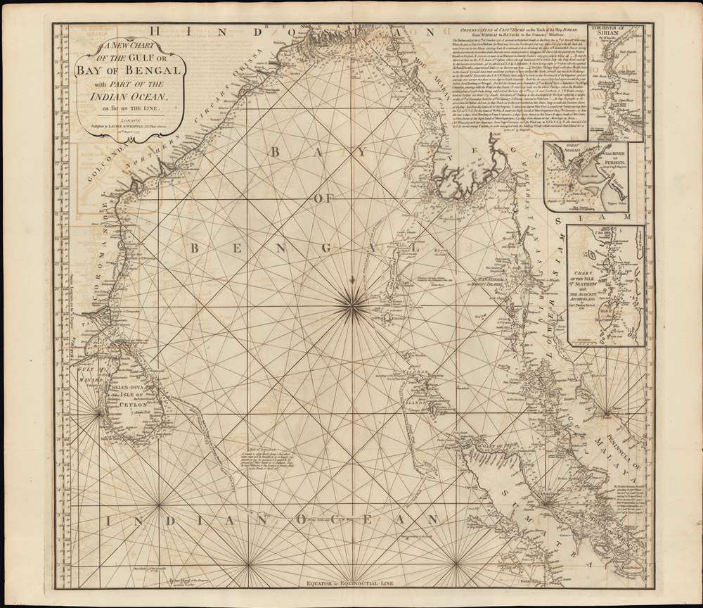
A New Chart of the Gulf or Bay of Bengal with Part of the Indian Ocean, as Far as the Line.
1797 (dated) 25 x 25.5 in (63.5 x 64.77 cm) 1 : 4100000
1797 (dated) 25 x 25.5 in (63.5 x 64.77 cm) 1 : 4100000
Description
This is a fine example of Laurie and Whittle's 1794 nautical chart or maritime map of the Bay of Bengal. The map covers from southeastern India and Ceylon (Sri Lanka) eastward to eastern Malaysia, north as far as the mouth of the Ganges River, and south to central Sumatra. There are three inset maps: The River of Sirian (based on D'Anville), but in fact the modern day Irrawaddy River, Burma / Myanmar; The River Perseen (based on Hayter), in fact the modern day Pathein River, Burma; and the Isle St. Mathew (after Thomas Forrest, 1783), which is probably the modern day Zadetky Island, Burma, but it is not clear. The Andaman and Nicobar Islands are in the center of the Bay, near the wind rose. In the upper right there is a lengthy observational note attributed to Captain Hicks and the ship Bahar on a 1770 voyage from Madras to Bengal in the Monsoon season.
Historical Context
In the late 17th century the Bay of Bengal was a critical transit for ships sailing between India and Southeast Asia. While the waters there are warm and generally calm, the region is subject to monsoon weather patterns that often befuddled European mariners, hence the great attention to sailing routes and the Hicks annotation.Publication History
This chart was prepared for the 1797 edition of in Laurie and Whittle's East-India Pilot . Although most charts in the Pilot were derived from earlier maps prepared for Jean-Baptiste d'Apres de Mannevillette's 1745 Neptune Oriental, this particular chart is a new and uniquely British production. We are aware of two editions, 1795 and 1797, as here, but there may be more.Cartographer
Laurie and Whittle (fl. 1794 - 1858) were London, England, based map and atlas publishers active in the late 18th and early 19th century. Generally considered to be the successors to the Robert Sayer firm, Laurie and Whittle was founded by Robert Laurie (c. 1755 - 1836) and James Whittle (1757-1818). Robert Laurie was a skilled mezzotint engraver and is known to have worked with Robert Sayer on numerous projects. James Whittle was a well-known London socialite and print seller whose Fleet Street shop was a popular haunt for intellectual luminaries. The partnership began taking over the general management of Sayer's firm around 1787; however, they did not alter the Sayer imprint until after Sayer's death in 1794. Apparently Laurie did most of the work in managing the firm and hence his name appeared first in the "Laurie and Whittle" imprint. Together Laurie and Whittle published numerous maps and atlases, often bringing in other important cartographers of the day, including Kitchin, Faden, Jefferys and others to update and modify their existing Sayer plates. Robert Laurie retired in 1812, leaving the day to day management of the firm to his son, Richard Holmes Laurie (1777 - 1858). Under R. H. Laurie and James Whittle, the firm renamed itself "Whittle and Laurie". Whittle himself died six years later in 1818, and thereafter the firm continued under the imprint of "R. H. Laurie". After R. H. Laurie's death the publishing house and its printing stock came under control of Alexander George Findlay, who had long been associated with Laurie and Whittle. Since, Laurie and Whittle has passed through numerous permeations, with part of the firm still extant as an English publisher of maritime or nautical charts, 'Imray, Laurie, Norie and Wilson Ltd.' The firm remains the oldest surviving chart publisher in Europe. More by this mapmaker...
Condition
Very good. Some transference and offsetting. Wear and verso reinforcement on some original fold lines.
References
OCLC 837645223.