This item has been sold, but you can get on the Waitlist to be notified if another example becomes available, or purchase a digital scan.
1712 Delisle Map of the Armagnac, Bearn and Bigorre Regions of France (Armagnac Brandy Region)
BearnDeLaBigorre-delisle-1712$200.00

Title
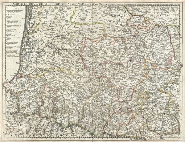
Carte du Bearn de la Bigorre de l'Armagnac et des Pays Voisins.
1712 (dated) 19 x 25 in (48.26 x 63.5 cm) 1 : 414000
1712 (dated) 19 x 25 in (48.26 x 63.5 cm) 1 : 414000
Description
This is a fine example of the 1712 Guillaume De L'isle map of the Bearn, Bigorre and Armagnac regions of France. It covers the southwest portion of France from Bazas south to Canfranc in Spain and from Pamplona east as far as Toulouse and includes parts of the Aquitaine and Midi-Pyrenees regions (historically the Gascony region). The map renders the entire region in extraordinary detail offering both topographical and political information with forest and mountains, including the Pyrenees, beautifully rendered in profile.
The Gascony region is known for its remarkable cuisine and is the home to both Foie Gras and Armagnac, France's oldest brandy. Parts of the departments of Gers, Landes and Lot-et-Garonne forms what was the historic county of Armagnac. Gers is also known for its production of Floc de Gascogne, a sweet wine and for its wild mushrooms. It is also home to Cotes de Gascogne, a wine-growing district that produces white wine. Landes is known for its production of Chalossais, a white cow cheese with a gentle, acidic edge. Tursan wine is also distilled here. The Lot-et-Garonne region is where the production of Buzet wines and Cabecou d'Antan takes place. Cabecou d'Antan is a small round goat cheese with a fine, creamy texture. The Pilgrimage to Santiago de Compostella also passes through the northern part of this region. Toulouse, identified here, is the capital of the Haute-Garonne region. An important stop on the medieval pilgrimage route to Santiago de Compostella, the region is also known for its truffles, agriculture, distilled spirits, wines, and cheese. Madrian, part of the Hautes-Pyrenees department, is best known for producing a powerful red wine made from the Tannat grape. The region also makes a number of cheeses, including Tomme Noire des Pyrenees and Roquefort cheese. The city of Moissac, in the upper right quadrant of this map, located in the department of Tarn-et-Garonne, is known for its fine desert grapes. This area produces a number of quality wines, such as AOC Fronton, Cotes de Brulhois, and the Vins de Pays des Coteaux et Terrasses de Montauban. The region is also a historic stopping point on the Pilgrimage to Santiago de Compostella.
This map was created by Guillaume De L'isle in 1712.
Cartographer
The De L'Isle family (fl. c. 1700 - c. 1760) (also written Delisle) were, in composite, a mapmaking tour de force who redefined early 18th century European cartography. Claude De L'Isle (1644 -1720), the family patriarch, was Paris based a historian and geographer under Nicholas Sanson. De L'Isle and his sons were proponents of the school of "positive geography" and were definitive figures, defining the heights of the Golden Age of French Cartography. Of his twelve sons, four, Guillaume (1675 - 1726), Simon Claude (1675 - 1726), Joseph Nicholas (1688 - 1768) and Louis (1720 - 1745), made a significant contributions to cartography. Without a doubt Guillaume was the most remarkable member of the family. It is said that Guillaume's skill as a cartographer was so prodigious that he drew his first map at just nine years of age. He was tutored by J. D. Cassini in astronomy, science, mathematics and cartography. By applying these diverse disciplines to the vast stores of information provided by 18th century navigators, Guillaume created the technique that came to be known as "scientific cartography", essentially an extension of Sanson's "positive geography". This revolutionary approach transformed the field of cartography and created a more accurate picture of the world. Among Guillaume's many firsts are the first naming of Texas, the first correct map of the Mississippi, the final rejection of the insular California fallacy, and the first identification of the correct longitudes of America. Stylistically De L'Isle also initiated important changes to the medium, eschewing the flamboyant Dutch style of the previous century in favor of a highly detailed yet still decorative approach that yielded map both beautiful and informative. Guillaume was elected to the French Academie Royale des Sciences at 27. Later, in 1718, he was also appointed "Premier Geographe du Roi", an office created especially for him. De L'Isle personally financed the publication of most of his maps, hoping to make heavy royalties on their sales. Unfortunately he met an untimely death in 1728, leaving considerable debt and an impoverished child and widow. De L'Isle's publishing firm was taken over by his assistant, Phillipe Buache who became, posthumously, his son in law. The other De L'Isle brothers, Joseph Nicholas and Louis De L'Isle, were employed in the Service of Peter the Great of Russia as astronomers and surveyors. They are responsible for cataloguing and compiling the data obtained from Russian expeditions in the Pacific and along the northwest coast of America, including the seminal explorations of Vitus Bering and Aleksei Chirikov. The De L'Isles, like their rivals the Vaugondys , must be considered speculative geographers. Speculative geography was a genre of mapmaking that evolved in Europe, particularly Paris, in the middle to late 18th century. Cartographers in this genre would fill in unknown areas on their maps with speculations based upon their vast knowledge of cartography, personal geographical theories, and often dubious primary source material gathered by explorers and navigators. This approach, which attempted to use the known to validate the unknown, naturally engendered many rivalries. The era of speculatively cartography effectively ended with the late 18th century explorations of Captain Cook, Jean Francois de Galaup de La Perouse, and George Vancouver. More by this mapmaker...
Condition
Very good. Minor wear along original centerfold. Minor spotting and offsetting. Blank on verso.
References
Rumsey 4764.031.