This item has been sold, but you can get on the Waitlist to be notified if another example becomes available, or purchase a digital scan.
1945 Gensler World War II 178th Engineer Combat Battalion Pictorial Route Map of Europe
BeaverTrails178th-gensler-1945$400.00

Title
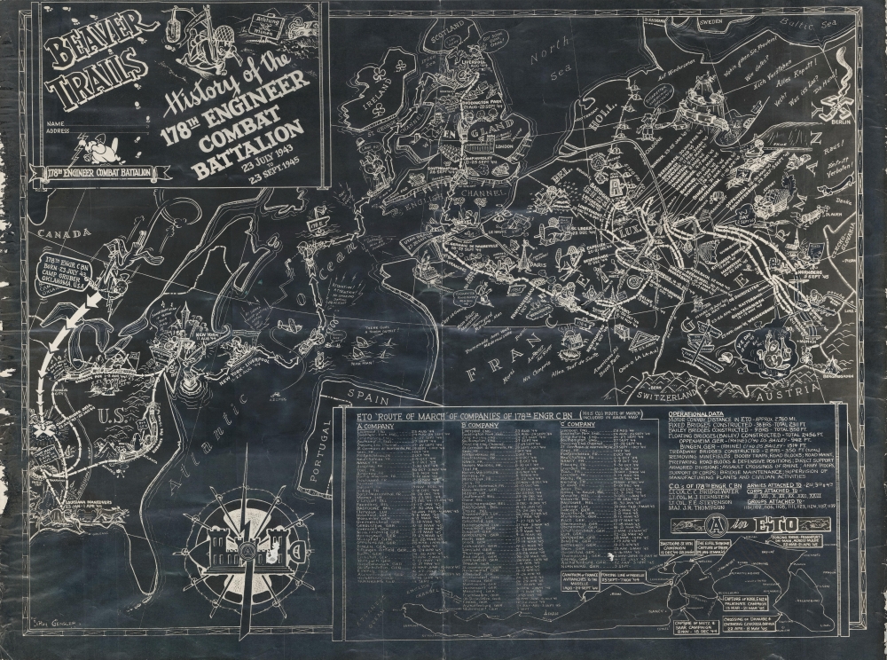
Beaver Trails. History of the 178th Engineer Combat Battalion 23 July 1943 to 23 Sept. 1945.
1945 (undated) 17.5 x 23 in (44.45 x 58.42 cm)
1945 (undated) 17.5 x 23 in (44.45 x 58.42 cm)
Description
This is a 1945 178th Engineer Combat Battalion World War II blackprint pictorial route map of Europe created by LeRoy Gensler. The map highlights the battalion's actions in combat, including during the Battle of the Bulge and building a bridge across the Rhine River.
A Closer Look
Arrows highlight the 178th's movements from Camp Gruber, Oklahoma, to the occupation of Nuremberg, Germany. Humorous vignettes and illustrations abound. Children ask for chocolate, candy, and cigarettes, and important landmarks, among them Parliament and the Eiffel Tower, appear. Beavers (the battalion's insignia) are drawn on trains, on ships crossing the Atlantic, building bridges, decorating Christmas trees, and in trucks. Useful phrases in French and German dot the map as well. V-E Day and V-J Day are prominently celebrated.Following the 178th
Cities and towns from Oklahoma to Germany are identified and the dates spent in each one are provided. In the U.S., the battalion spent time in Oklahoma, Louisiana, and Texas before shipping out for the Point of Embarkation in August 1944. They left New York on August 11, 1944, and arrived in Liverpool on the 22nd. After spending a month in England, the battalion arrived on Utah Beach on September 27-28, 1944, and then fought their way through France, Belgium, and Germany. In the lower right quadrant, a table lists the cities along 'A', 'B', and 'C' companies' route alongside statistics detailing the battalion's accomplishments. A smaller map occupies the lower right providing an overview of the battalion's movements from Avranches to Nuremberg.World War II Route Maps
Maps tracing unit movements during World War II were created by both American and British forces during and after the war. As a genre, these maps represent a broad range of aesthetics, from the purely functional that label places and provide dates, to the artistic, even comic. Many combine the three and provide a visually striking but historically informative summary of the unit's peregrinations.Publication History and Census
This map was drawn by Staff Sergeant LeRoy Gensler and published in Europe in 1945. This is the only known example of the present edition. A full color edition of the map was published as well, of which we note two digitized examples in private hands.Cartographer
LeRoy Adam Gensler (August 15, 1915 - January 13, 1976) was an American cartoonist and World War II veteran. Born in Lebanon, Pennsylvania, Gensler learned cartooning after picking up a correspondence cartooning course that his grandfather abandoned. He began working for the Reading Times in 1937. He entered the U.S. Army on September 28, 1943, and was assigned to the 178th Engineer Combat Battalion at Camp Gruber, Oklahoma. He was a member of the Headquarters Company and attained the rank of Staff Sergeant. Gensler served overseas with the 178th from August 11, 1944, through January 14, 1946. Gensler originally left Europe for the U.S. in December 1945, but the ship he was traveling on was damaged by a hurricane mid-crossing and was forced to seek repairs in the Azores, where Gensler and the rest of the soldiers traveling home spent a few weeks. After safely returning to the U.S., he was discharged on January 17, 1946, and returned to the Reading Times. He moved to the Reading Eagle, the competing newspaper, in 1952. He married Dorothy I. Keefer on November 23, 1939 (Thanksgiving Day), with whom he had one son. More by this mapmaker...
Condition
Good. Wear and scuffing to left and right margins. Light scuffing to engineer insignia in compass rose.