This item has been sold, but you can get on the Waitlist to be notified if another example becomes available, or purchase a digital scan.
1867 Beers City Map of Tarrytown (Sleepy Hollow), New York
BeekmantownTarrytown-beers-1867$187.50

Title
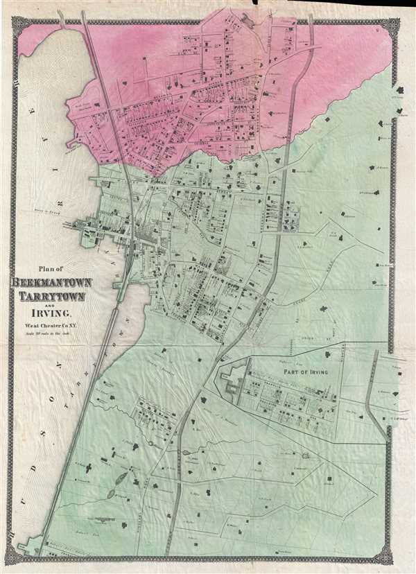
Plan of Beekmantown Tarrytown and Irving West Chester Co. N.Y.
1867 (undated) 26 x 19 in (66.04 x 48.26 cm) 1 : 3960
1867 (undated) 26 x 19 in (66.04 x 48.26 cm) 1 : 3960
Description
This is an 1867 Frederic Beers map of Beekmantown, Tarrytown, and Irving, New York. The map depicts the region along the Hudson River known as the Tappen Zee in extraordinary detail, with individual buildings (with the names of their owners!) illustrated in both Tarrytown and Beekmantown. Estates outside the towns are also depicted in detail, from the boundaries of each individual estate down to the shape of the mansions and the proprietor's names. Tarrytown is a prominent town in the area and the location of the important Tappen Zee Bridge. It is also the setting for the wonderful 19th century short story The Legend of Sleepy Hollow. The Hudson River Line is also illustrated.
This map was produced by the prominent 19th century American map publisher Frederic Beers in his seminal 1868 Atlas of New York and Vicinity.
This map was produced by the prominent 19th century American map publisher Frederic Beers in his seminal 1868 Atlas of New York and Vicinity.
Cartographer
The Beers family (Fredrick, Silas, James and Daniel) (fl. c. 1850 - 1886), along with Charles and Augustus Warner, were prominent map publishers working from the 1850s to the late 1880s. Often publishing under the Warner & Beers designation, the combined firms produced a series of important state and county atlases and map of much of the northeastern United States. Many of their regional maps are among the most detailed and well laid out maps ever produced of their respective regions. Because Warner & Beers county maps were often detailed down to the individual homes and landowners, they have become highly sought after by general and family historians. In additional to producing maps of surpassing detail, Warner & Beers also maintained an earlier generation's attention to detail and quality while publishing in an era ever increasingly dominated by the low cost printing methods used by the publishing empires of Rand McNally and George Cram. More by this mapmaker...
Condition
Very good. Verso repair to fold separation. Blank on verso.
References
Rumsey 0064.013.