1957 Jennings Pictorial Map of Belfast, Maine
BelfastMaine-jennings-1957$400.00
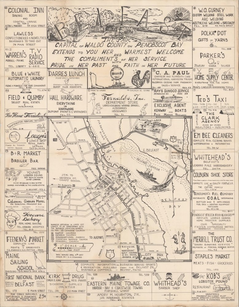

Title
Belfast The Fair Capital of Waldo County on Penobscot Bay Extends to You Her Warmest Welcome...
1957 (dated) 21 x 16.75 in (53.34 x 42.545 cm) 1 : 8400
1957 (dated) 21 x 16.75 in (53.34 x 42.545 cm) 1 : 8400
Description
An unrecorded 1957 pictorial map of Belfast, Maine by local artist George H. Jennings. An impressive work of artistry, it highlights local businesses, attractions, and culture, especially the town's orientation towards the sea.
A Closer Look
Coverage includes the town of Belfast, Maine, with East Belfast, the Passagassawakeag River, and Belfast Bay, which meets the larger Penobscot Bay. Roads are labeled, including U.S.-1, which continues down the coast to Boston and beyond, and, in the opposite direction, northwards to the Canadian border. Churches, waterways, and several dozen local businesses are also marked. The Jennings family business - yachtsmen, coast pilot, marine appraiser, and compass adjustor - appears at bottom-right and bottom-left of the advertisement section. Illustrations appear throughout, including maritime motifs on the map and drawings relevant to the advertisements surrounding the map.Publication History and Census
This map was drawn by George H. Jennings in 1957. It is unclear if the artist was the elder George H. Jennings, a ship captain, or his son, but presumably it is the latter given his subsequent artistic output. If so, this map would be a very early work in his oeuvre, produced during his adolescence or very early adulthood. The map is not known to exist in any institutional collections and has no known history on the market.Cartographer
George Henry Jennings (fl. c. 1957 - present) is an illustrator, artist, photographer, author, and inventor based in the Penobscot Bay region of Maine. His father was a graduate from the inaugural class of the Maine Maritime Academy in 1943 who worked as a ship pilot while collecting information and photographs of local maritime history. The younger Jennings inherited these interests, and is now considered an authority on local history. His artistic output sticks close to these same themes, consisting mostly of illustrations of various types of ships seen off the Maine coast. More by this mapmaker...
Condition
Fair. Light wear along original folds. Slight loss on bottom border. 5.5 inch tear on bottom left professionally repaired.