This item has been sold, but you can get on the Waitlist to be notified if another example becomes available, or purchase a digital scan.
1747 Homann Heirs Map of Belgium and the Netherlands
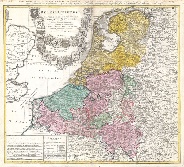
BelgiiUniversi-homannheirs-1747$175.00

Title
Belgii Universi seu Inferioris Germaniae quam XVII Provinciae Austriaco, Gallico et Batavo sceptro parentes constituunt nova Tabula Geographica a Tobia Majero Math. Cult. ad leges legitimae delineationis revocata Cura et studio Homanniorum Heredum A. 1747.
1747 19.5 x 21 in (49.53 x 53.34 cm)
1747 19.5 x 21 in (49.53 x 53.34 cm)
Description
A beautifully detailed 1747 Homann Heirs map of Belgium and the Netherlands (Holland). Includes Belgilum proper as well as the seven states of the Belgian Federation – what is today Holland or the Netherlands. Also includes parts of England and extends into eastern Germany past the Rhine River. Title elaborate cartouche in the upper left quadrant, filling the North Sea, features the armorial shields of the Belgian Counties as well as those of the seven states of the federation: Geldern, Holland, Zeeland, Utrecht, Friesland, Ober Issel, and Groningen. Alternate title in French outside of upper margin. This map was drawn by Johann Tobias Mayer for inclusion the 1752 Homann Heirs Maior Atlas Scholasticus ex Triginta Sex Generalibus et Specialibus…. Most early Homann atlases were 'made to order' or compiled of individual maps at the request of the buyer. However, this rare atlas, composed of 37 maps and charts, was issued as a 'suggested collection' of essential Homann Heirs maps.
Cartographer
Homann Heirs (1730 - 1848) were a map publishing house based in Nuremberg, Germany, in the middle to late 18th century. After the great mapmaker Johann Baptist Homann's (1664 - 1724) death, management of the firm passed to his son Johann Christoph Homann (1703 - 1730). J. C. Homann, perhaps realizing that he would not long survive his father, stipulated in his will that the company would be inherited by his two head managers, Johann Georg Ebersberger (1695 - 1760) and Johann Michael Franz (1700 - 1761), and that it would publish only under the name 'Homann Heirs'. This designation, in various forms (Homannsche Heirs, Heritiers de Homann, Lat Homannianos Herod, Homannschen Erben, etc..) appears on maps from about 1731 onwards. The firm continued to publish maps in ever diminishing quantities until the death of its last owner, Christoph Franz Fembo (1781 - 1848). More by this mapmaker...
Condition
Very Good condition. Discoloration along upper part of original centerfold. Somemarginal foxing, especially along upper margin. Else clean. Blank on verso.