This item has been sold, but you can get on the Waitlist to be notified if another example becomes available, or purchase a digital scan.
1748 Homann Heirs Map of Holland (Netherlands)
BelgiumFoederatum-homannheirs-1748$162.50

Title
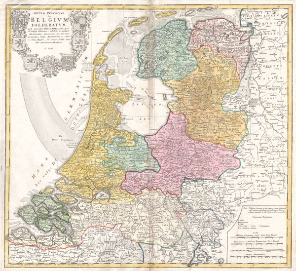
Septem Provinciae seu Belgium Foederatum: quod generaliter Hollandia audit, speciali mappa delineatum, adhibitis in auxilium observationibus astronomicis nec non mensurationibus Snelii, Muschenbrokii…
1748 19 x 20.5 in (48.26 x 52.07 cm)
1748 19 x 20.5 in (48.26 x 52.07 cm)
Description
A beautifully detailed 1748 Homann Heirs map seven states of the Belgian Federation – what is today Holland or the Netherlands. Title cartouche in the upper left quadrant features the armorial coasts of the seven states: Geldern, Holland, Zeeland, Utrecht, Friesland, Ober Issel, and Groningen. This map was drawn by Johann Tobias Mayer for inclusion the 1752 Homann Heirs Maior Atlas Scholasticus ex Triginta Sex Generalibus et Specialibus…. Most early Homann atlases were 'made to order' or compiled of individual maps at the request of the buyer. However, this rare atlas, composed of 37 maps and charts, was issued as a 'suggested collection' of essential Homann Heirs maps.
Cartographer
Homann Heirs (1730 - 1848) were a map publishing house based in Nuremberg, Germany, in the middle to late 18th century. After the great mapmaker Johann Baptist Homann's (1664 - 1724) death, management of the firm passed to his son Johann Christoph Homann (1703 - 1730). J. C. Homann, perhaps realizing that he would not long survive his father, stipulated in his will that the company would be inherited by his two head managers, Johann Georg Ebersberger (1695 - 1760) and Johann Michael Franz (1700 - 1761), and that it would publish only under the name 'Homann Heirs'. This designation, in various forms (Homannsche Heirs, Heritiers de Homann, Lat Homannianos Herod, Homannschen Erben, etc..) appears on maps from about 1731 onwards. The firm continued to publish maps in ever diminishing quantities until the death of its last owner, Christoph Franz Fembo (1781 - 1848). More by this mapmaker...
Condition
Good condition. Discoloration along upper part of original centerfold. Else clean. Blank on verso.