1858 Walling Wall Map of Berkshire County, Massachusetts (the Berkshires)
BerkshireCountyMA-walling-1858-2$3,000.00


Title
Map of the County of Berkshire Massachusetts.
1858 (dated) 61 x 61.5 in (154.94 x 156.21 cm) 1 : 50688
1858 (dated) 61 x 61.5 in (154.94 x 156.21 cm) 1 : 50688
Description
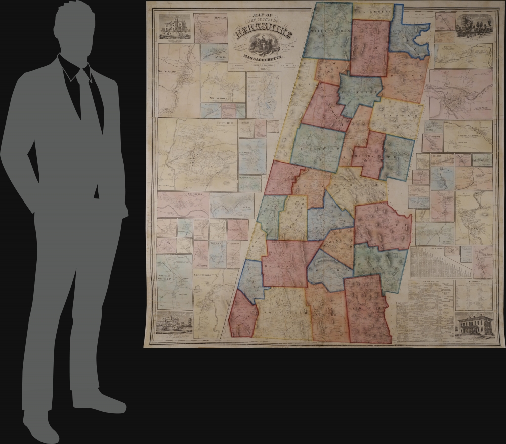
This is an 1858 Henry Francis Walling wall map of Berkshire County, Massachusetts - the summer arts mecca. When issued, it was by far the largest and most detailed map of the Berkshires available.
A Closer Look
The map depicts Berkshire County from Williamstown and North Adams to New Boston and Sheffield. Divided into townships, a highly detailed view of the county is presented. Property owners are named throughout. Inset maps of varying size frame the central: Dalton, North Adams, Lee, Glendale, Mill River, Pittsfield, Stockbridge, Williamstown, South Adams, Great Barrington, and East Lee. Views of the Sedgwick Institute (Great Barrington), Collins Institute (Great Barrington), the Berkshire Medical Institute (Pittsfield), and Maplewood Young Ladies Institute (Pittsfield) decorate the corners. Tables of distances and statistics, along with a business directory and a geological map of Berkshire County, are also included.Center for the Arts
In the 19th century, Berkshire County became popular with the nation's elite, where they built palatial 'cottages' away from the hustle and bustle of city life. The arts followed the money, and the entire region became a haven for the visual and performing arts. Today, the Berkshire Hills are the summer home of the Boston Symphony Orchestra at Tanglewood (Lenox and Stockbridge), Jacob's Pillow Dance Festival (Becket), and the Williamstown Theater Festival. The Massachusetts Museum of Contemporary Art (MASS MoCA), one of the largest centers for contemporary visual art and performing arts in the United States, is in North Adams. Nearby Williamstown boasts both Williams College and the Clark Art Museum. The Norman Rockwell Museum is in Stockbridge.Publication History and Census
This map was created by Henry Francis Walling and published by Smith, Gallup and Company in 1858. We see perhaps ten examples in OCLC, and the map is scarce to the market. This is only the second example we've handled in some twenty-five years.Cartographer
Henry Francis Walling (June 11, 1825 - April 8, 1889) was an American civil engineer, cartographer, surveyor, and map publisher active from the middle to late 19th century. Walling was born in Providence, Rhode Island. He studied/worked at the Providence Athenaeum before discovering a talent for mathematics and surveying. Walling took a position with Samuel Barrett Cushing (1846 - 1888), a Providence-based civil engineer with whom he issued in 1846 a revision of James Steven's Topographical Map of the State of Rhode-Island. Walling established himself independently around 1850 and immediately began preparing a series of town plans focusing on Bristol County, near Providence. Buoyed by widespread interest in his plans, Walling expanded his operations to Massachusetts, where, by 1857, he had produced no less than 50 town plans. Apparently, Walling's business model involved a contract with town officials to produce a certain number of maps, after which he acquired the right to print and sell additional copies on his own account. This work eventually led to Walling's appointment as Massachusetts "Superintendent of the State Map", a designation that began appearing on his maps around 1855. While Walling's work focused heavily on city and county maps, he successfully published three scarce state maps: Maine, Vermont, and Rhode Island. In 1856, Walling relocated his headquarters to New York City, where he had better access to quality lithographers. The Civil War (1861 - 1865) proved difficult for Walling, and diminished sales may have forced him into a partnership with Ormando W. Gray, with whom he published numerous state, county, and national atlases in the 1860s and 1870s. Around 1880, Walling took a post with the U.S. Coast Survey, with whom he worked on various charts until requesting a transfer in 1883 to the newly formed U.S. Geological Survey. Walling remained with the Geological Survey until his untimely death of a heart attack in April 1889. More by this mapmaker...
Condition
Very good. Full professional restoration. Backed on linen. No rollers.
References
OCLC 883714237.