1867 Weyss Map of the Bermuda Hundred Campaign during the U.S. Civil War
BermudaHundred-weyss-1867-2$375.00

Title
Bermuda Hundred.
1867 (dated) 20.25 x 30 in (51.435 x 76.2 cm) 1 : 42240
1867 (dated) 20.25 x 30 in (51.435 x 76.2 cm) 1 : 42240
Description
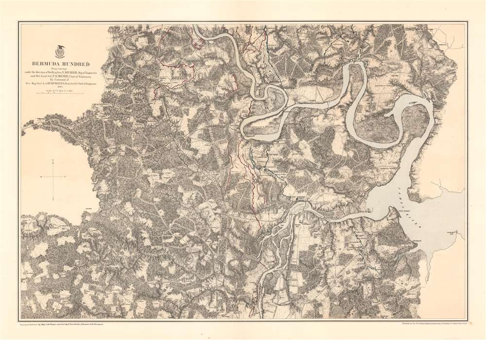
This is an 1867 John Weyss and Nathaniel Michler map of the Bermuda Hundred Campaign during the American Civil War. The map depicts the region from the Dunnson farm to the Jordan's Point Lighthouse on the James River and from Chaffin's Bluff and Drury's (Drewry's) Bluff to the J. Mason farm.
The Bermuda Hundred Campaign
A series of battles fought in May 1864, the Bermuda Hundred Campaign was fought between the Union Army of the James led by Major General Benjamin Butler and a much smaller Confederate force under the command of General P.G.T. Beauregard. Butler and the Army of the James landed at Bermuda Hundred, a fishing village situated on a peninsula at the confluence of the Appomattox and James Rivers between Richmond and Petersburg, Virginia, on May 5, the same day that General Grant and the Army of the Potomac launched the Overland Campaign at the Battle of the Wilderness. With the ultimate aim of severing the Richmond and Petersburg Railroad, a vital rail link to the south, a series of battles ensued. Many of these battles happened at locations labeled here, including the Battle of Port Walthall Junction, the Battle of Chester Station, the Battle of Proctor's Creek (also known as the Battle of Drewry's Bluff), and the Battle of Ware Bottom Church. Although Butler commanded a superior force to that of Beauregard, the best he was able to achieve was a stalemate. Butler was one of the 'political generals' appointed because of their loyalty to Lincoln and his reelection campaign and was not a very talented commander. Even with two very talented subordinates, Butler and the Army of the James were 'bottled-up' in the vicinity of Bermuda Station and were not able to occupy a large number of Confederate forces, allowing these Confederate soldiers to be reassigned to fight General Grant's Army of the Potomac at Cold Harbor and elsewhere.A Closer Look at the Map
With Confederate forces noted in red and Federal (Union) forces in blue, the many actions of the Bermuda Hundred Campaign are illustrated here, although the progression of the campaign is not noted. Numerous forts, batteries, and other locations integral to the fighting are illustrated and labeled, as are myriad farms and homesteads. Roads and railroads, including the Richmond and Petersburg Railroad, the Richmond and Petersburg Turnpike, and the Petersburg and City Point Railroad, are also identified.Publication History and Census
This map was surveyed and drawn by Major John E. Weyss under the command of Nathaniel Michler, engraved by Julius Bien, and published by the War Department in Military Maps illustrating the Operations of the Armies of the Potomac and James in 1869. While this map is well represented in institutional collections, it is rarely on the private market.CartographerS
John E. Weyss (1820 - June 24, 1903) was an Austrian-American illustrator, cartographer, and engineer. Born in Vienna, Weyss immigrated to the United States in 1848 and settled in New York. He served as a member of the U.S. Government's Mexican Boundary Survey (1849 - 1855), led by Major William Hemsley Emory, because of his training as an illustrator. In the capacity of a civilian artist working for the army, Weyss contributed several illustrations for Emory's report, which was published in 1857-59. Weyss is also credited on eleven of the report's maps. At the outbreak of the American Civil War, Weyss held a position as a civil engineer for the state of Kentucky. Weyss received a commission as a major from the Governor of Kentucky and, due to his professional experience, was assigned to the staff of Captain Nathaniel Michler, the chief topographical officer in the Army of the Ohio. In this role he did survey work for maps of the vicinity of Shiloh and Corinth, both sites of major Civil War battles. Weyss then joined Captain Michler when he moved to the staff of General Rosecrans in late 1862, for whom they made a series of maps of the Battle of Stones River. Weyss and Michler were then transferred to the Army of the Potomac in May, 1863. One of Weyss's first assignments for the Army of the Potomac was a map of the vicinity of Harper's Ferry, Virginia, for which he produced a highly detailed map of the very complex topography of the region. Soon, Weyss was made responsible for the day-to-day detailed mapping during the siege at Petersburg. After the war, Weyss served as the principal surveyor under the direction of Michler during the creation of the atlas Military maps illustrating the operations of the armies of the Potomac and James, May 4th 1864 to April 9th 1865, that was published in 1869. Weyss served the U.S. Army Corps of Engineers for another twenty years, until he retired sometime in the 1880s. Weyss died on June 4, 1903, in Washington, D.C. More by this mapmaker...
Nathaniel Michler (September 13, 1827 - July 17, 1881) was an American military officer and mapmaker who served during the American Civil War. Born in Easton, Pennsylvania, Michler attended West Point, from which he graduated seventh in his class. Commissioned as a 2nd Lieutenant in the Topographical Engineers, Michler participated in the Mexican Boundary Survey from 1851 until 1857, when he was transferred to serve as the chief topographical engineer in surveys for a proposed canal from the Gulf of Darien to the Pacific Ocean from 1858 until 1860. He held the rank of Captain at the outbreak of the American Civil War and served with the Army of the Cumberland from 1861 - 1863, then was transferred to the Army of the Potomac and built defensive works for the Union Army at the Battles of the Wilderness, Spotsylvania, Cold Harbor, and Petersburg. He was promoted to Colonel in August 1864 and brevetted Brigadier General in April 1865. After the war, Michler served as superintendent in the District of Columbia until 1871 and from 1872 to 1875 was chief engineer with the General Commanding Division of the Pacific. He acted as military attaché for the United States Legation in Vienna, Austria from 1878 to 1880. Learn More...
Julius (Julien) Bien (September 27, 1826 - December 21, 1909) was a German-Jewish lithographer and engraver based in New York City. Bien was born in Naumburg, Germany. He was educated at the Academy of Fine Arts, Cassell and at Städel's Institute, Frankfurt-am-Main. Following the suppression of the anti-autocratic German Revolutions of 1848, Bien, who participated in the pan-German movement, found himself out of favor in his home country and joined the mass German immigration to the United States. Bien can be found in New York as early as 1849. He established the New York Lithographing, Engraving & Printing Company in New York that focused on the emergent chromo-lithograph process - a method of printing color using lithographic plates. His work drew the attention of the U.S. Government Printing Office which contracted him to produce countless government maps and surveys, including the Pacific Railroad Surveys, the census, numerous coast surveys, and various maps relating to the American Civil War. Bien also issued several atlases both privately and in conjunction with a relation, Joseph Bien. At the height of his career Bien was elected president of the American Lithographers Association. After his death in 1909, Bien's firm was taken over by his son who promptly ran it into insolvency. The firm was sold to Sheldon Franklin, who, as part of the deal, retained the right to publish under the Julius Bien imprint. In addition to his work as a printer, Bien was active in the New York German Jewish community. He was director of the New York Hebrew Technical Institute, the New York Hebrew Orphan Asylum, and president of the B'nai B'rith Order. Learn More...
Source
War Department, Military Maps illustrating the Operations of the Armies of the Potomac and James May 4th 1864 to April 9th 1865 including Battlefields of the Wilderness, Spottsylvania, Northanna, Totopotomoy, Cold Harbor, The Siege of Petersburg and Richmond Battlefields of Five Forks, Jetersville and Sailor's Creek, Highbridge, Farmville, and Appomattox Court-House. (Washington) 1869.
Military Maps Illustrating the Operations of the Armies of the Potomac and James, published in 1869, compiled all the maps created by Major Nathaniel Michler and Major John E. Weyss of all the major battlefields of the eastern theater of war during the American Civil War. These maps blended together surveys done by soldiers both before and during battles and work done by Weiss and his team of engineers after the war was over. Many of these maps were reduced in order to be republished in the Atlas to Accompany the Official Records of the Union and Confederate Armies, which has become the standard reference for Civil War military maps.
Condition
Very good. Verso repairs to centerfold separations in margins. Light damp staining in margins. Blank on verso.
References
Rumsey 3881.010. OCLC 56794786.