This item has been sold, but you can get on the Waitlist to be notified if another example becomes available, or purchase a digital scan.
1805 William Heather 'Blueback' Nautical Map of Bermuda
Bermudas-heather-1805$2,500.00

Title
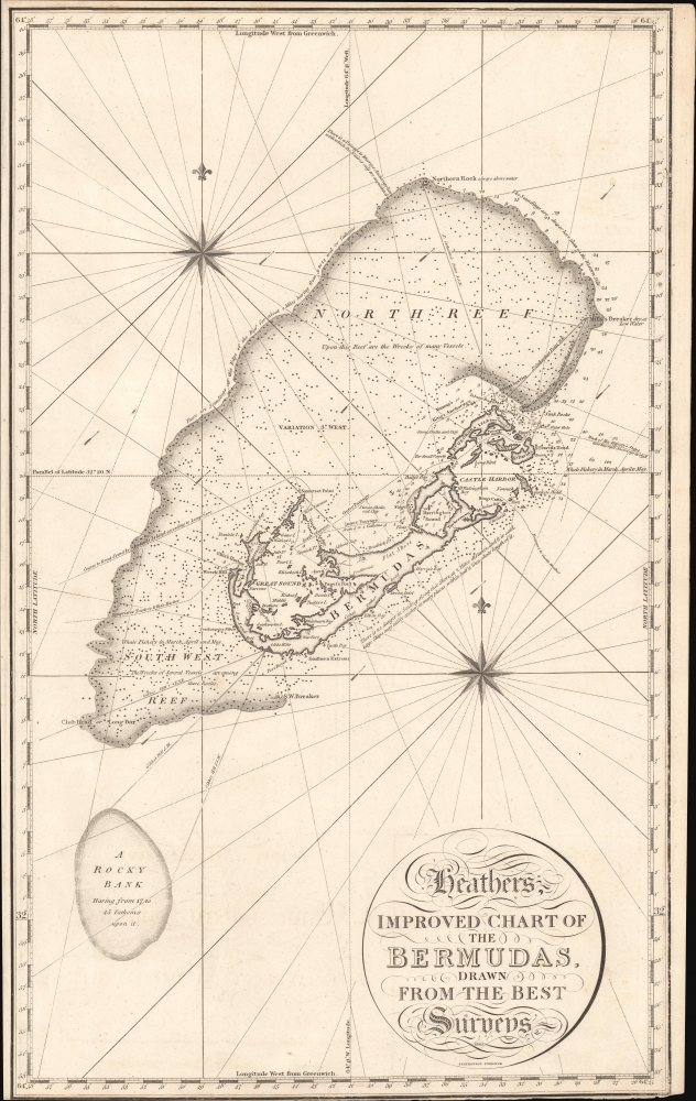
Heathers, Improved Chart of the Bermudas, Drawn from the Best Surveys.
1805 (dated) 25.5 x 16.2 in (64.77 x 41.148 cm) 1 : 141000
1805 (dated) 25.5 x 16.2 in (64.77 x 41.148 cm) 1 : 141000
Description
This is the rare 1805 William Heather blueback nautical map of Bermuda. It is almost certainly the first publication of Thomas Hurds's groundbreaking 1789 - 97 hydrographic survey of Bermuda - though unofficial and possibly pirated.
Over nearly a decade of meticulous work, Hurd discovered what pirates and smugglers long knew: that Bermuda possessed several deep, well-protected harbors that could be approached from different directions provided one had the necessary hydrographic expertise. Without such knowledge, however, navigation remained perilous. This combination of natural concealment and strategic accessibility made Bermuda an ideal, defensible outpost for projecting British naval power. It soon became the Royal Navy's principal base in the mid-Atlantic - often referred to as 'the Gibraltar of the Atlantic' - and Hurd's survey laid the groundwork for all subsequent Admiralty mapping of the islands.
A Closer Look
Although unattributed as such, this map bears a striking resemblance to later maps produced using the 1789 - 97 surveys of Royal Navy hydrographer Thomas Hannaford Hurd. For political reasons, Hurd's surveys were not published by the Admiralty until 1827, but this chart suggests that private chart makers, in this case, William Heather, had access to Hurd's surveys, at least in part. The distinctive treatment of the vast reef northwest of Bermunda is significant, as are the markers along the southeast coast. This map, in fact, offers fewer soundings but otherwise greater overall detail than the 1827 Hurd Admiralty publication (Geographicus: Bermuda-hurd-1827). It is interesting, as well, to compare this chart with the Blunt Chart, published in 1819, which copies Heather shamelessly.The Surveys and Surveyors
The genesis of Hurd's hydrographic survey stemmed from the Royal Navy's acquisition of land on Ireland Island for the establishment of a dockyard following the American Revolutionary War (1775 - 1783). The resulting chart represents the product of nearly a decade of sustained effort (1789 - 1797) by Hurd and his team. This group included Lieutenant Andrew Fitzherbert Evans (1767 - 1826), two skilled draughtsmen, and, indirectly, Royal Engineers land surveyor Andrew Durnford (1744 - 1798). Central to the project's success were several Bermudian pilots of African descent whose exceptional knowledge of local waters proved invaluable. Among them, James' Jemmy' Darrell, Jacob Pitcairn, and Tom Bean played especially critical roles. Darrell (1749 - 1815) is the most documented: while still enslaved during his work with Hurd, he gained widespread recognition for expertly piloting Admiral George Murray's 74-gun HMS Resolution into anchorage near St. George's Island in 1795 - a feat never before accomplished with a vessel of that size. In recognition of his skill, the Governor's Office purchased Darrell's freedom, and he was later appointed one of Bermuda's first official 'King's Pilots' alongside Pitcairn. Darrell went on to acquire property and became an outspoken proponent of the rights of free people of color and the abolition of slavery in Bermuda.Historical Context
This chart is the result of surveys initiated in the wake of the American Revolutionary War, during which Bermuda's strong trade ties with the North American colonies nearly drew it into the conflict. In 1775, the Continental Congress exempted Bermuda from its trade embargo against British territories, allowing the islands to briefly thrive as a center of illicit commerce. To reassert control, Britain responded by deploying a garrison and installing Loyalist officials. Following the war, Bermuda remained Britain's sole Atlantic stronghold between Nova Scotia and the Caribbean, prompting the construction of the naval dockyard and Hurd's assignment to chart its waters.Over nearly a decade of meticulous work, Hurd discovered what pirates and smugglers long knew: that Bermuda possessed several deep, well-protected harbors that could be approached from different directions provided one had the necessary hydrographic expertise. Without such knowledge, however, navigation remained perilous. This combination of natural concealment and strategic accessibility made Bermuda an ideal, defensible outpost for projecting British naval power. It soon became the Royal Navy's principal base in the mid-Atlantic - often referred to as 'the Gibraltar of the Atlantic' - and Hurd's survey laid the groundwork for all subsequent Admiralty mapping of the islands.
Blueback Charts
Blueback nautical charts began appearing in London in the late 18th century. Bluebacks, as they came to be called, were privately published large-format nautical charts known for their distinctive blue paper backing. The backing, a commonly available blue manila paper traditionally used by publishers to wrap unbound pamphlets, was adopted as a practical way to reinforce the low-quality paper used by private chart publishers to cut costs. That being said, not all blueback charts are literally backed with blue paper; some are unbacked (as here) or backed with linen. Moreover, as blueback charts, which were typically composed of multiple sheets, they were designed in a modular fashion so that multiple charts could be joined to create truly massive custom maps suited for specific voyages. The earliest known blueback charts include a 1760 chart issued by Mount and Page and a 1787 chart issued by Robert Sayer. The tradition took off in the early 19th century, when British publishers like John Hamilton Moore, Robert Blachford, James Imray, William Heather, John William Norie, Charles Wilson, David Steel, R. H. Laurie, and John Hobbs, among others, rose to dominate the chart trade. Bluebacks became so popular that the convention was embraced by chartmakers outside of England, including Americans Edmund March Blunt and George Eldridge, as well as Scandinavian, French, German, Russian, and Spanish chartmakers. Blueback charts remained popular until the late 19th century when government-subsidized organizations like the British Admiralty Hydrographic Office and the United States Coast Survey began issuing their own superior charts on high-quality paper that did not require reinforcement.Publication History and Census
This map was engraved by John Stephenson in London for publication in 1805 by William Heather. Heather was a British blueback publisher, and this is in the style of contemporary blueback charts but is not actually backed with blue paper. This map is impressively rare, with only one other verifiable example known - at the Boston Public Library. It is likely that an example is also held at the British Library, though we do not see it in either their catalog or the catalogs at the Greenwich Maritime Museums. No market history.CartographerS
William Heather (1793 – 1812) was a British nautical chart engraver and publisher active in the late 18th and early 19th centuries. Heather was born in Lambeth but shortly after relocated with his family to the parish of Christ Church, Southwark. He was apprenticed to George Michell, a London stationer. Heather reached his maturity and became a member of the Stationers Company in 1789. His earliest known cartographic work appeared in conjunction with the offices of John Hamilton Moore, with whom he was employed. Around 1793 Heather started his own competing nautical chart business at 157 Ledenhall Street, London. This office remained the home of his firm for an astounding 85 years. Heather soon took on the Scotsman John William Norie as an apprentice Norie eventually inherited Heather's business and map plates, beginning his own long career as a maker of English blueback charts. More by this mapmaker...
John Stephenson (fl. c. 1790 - 1836) was a British engraver active in the London nautical chart trade in the late 19th and early 19th century. There is some speculation by Lawrence Worms, Baynton-Williams, and other map scholars, that Stephenson apprenticed with the stationer Charles John Downes. Stephenson engraved for the nautical chart firm of John Hamilton Moore until 1793, when he moved on to the firm of William Heather. Heather's firm was subsequently inherited, along with Stephenson, by John William Noire. Stephenson's characteristic style, involving strong lines, elaborate typographic embellishment, and finely-engraved detail, it is commonly associated with John Noire. Learn More...
Condition
Very good. Narrow bottom margin.
References
Boston Public Library, Leventhal Map Center, G9120 1805.H43.