2013 Atikart Historical Map of the Bialystok Ghetto
BialystokGhetto-atikart-2013$300.00


Title
Białostockie Getto 1941-1943.
2013 (undated) 17.625 x 25 in (44.7675 x 63.5 cm) 1 : 5000
2013 (undated) 17.625 x 25 in (44.7675 x 63.5 cm) 1 : 5000
Description
This is a 2013 Atikart historical folding map of the Bialystok Ghetto in Bialystok, Poland, documenting the horrors of the Holocaust in that city.
Bialystok lies within the portion of eastern Poland that was occupied by the Soviet Union in 1939, soon after the Nazi invasion of Poland from the west, and was incorporated into the Byelorussian Soviet Socialist Republic. Less than two years later, the Germans invaded the Soviet Union and the city came under German occupation, with its sizable Jewish population being immediately attacked and terrorized by German police battalions who were handmaidens of the Holocaust. Horrifically, following a common tactic at this stage of the Holocaust, the city's Great Synagogue was burned down with hundreds of Jews locked inside. In the following weeks, thousands more were killed in mass shootings in and around Bialystok by police battalions, Einsatzgruppe B, and associated units.
A month after occupying Bialystok and unleashing this terror, the Germans moved to establish the Bialystok Ghetto on July 26, 1941, following a model already being implemented in Warsaw. The Jewish area of the city was walled off, any non-Jewish Poles living there were expelled, and Jews from throughout the city and surrounding region were moved in, some 50,000 people in all, with up to three families sharing a single room. As in Warsaw, conditions were horrific, with forced labor operations set up and rations deliberately limited, leading to starvation and disease. Any disobedience was punished severely and publicly with shootings and hangings. In February 1943, the Nazis began shipping Jews of the Bialystok Ghetto to extermination camp. By the summer, news of the fate of the Warsaw Ghetto and of the Jews sent to extermination camps had reached the Bialystok Ghetto, leading to the formation of a resistance movement that, as in Warsaw, fought to the bitter end against the ghetto's 'final liquidation.' Also as in Warsaw, a small number of Jews managed to escape in the course of the uprising, but they represented only a small percentage of the Jews who had been through the Bialystok Ghetto.
This map represents an important evolution in Poland's understanding of the history of the Second World War and the Holocaust. In the Soviet era, the extermination of the vast majority of prewar Poland's Jewish population was minimized, as was the role of some Poles in aiding their persecution to emphasize collective national and international suffering. The victory of the Red Army and its allies in the Polish underground was glorified above all else. The fall of communism led to more open discussion alongside a surge in national pride, resulting in a contested discourse. While historians and museums, such as the Bialystok Museum of History, which helped produce this map, have explored the destruction of Poland's Jews in great detail, ascribing even partial blame to Poles or to prewar Polish Antisemitism is not only controversial but, since 2018, potentially illegal.
A Closer Look
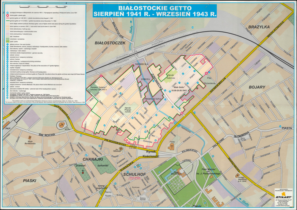
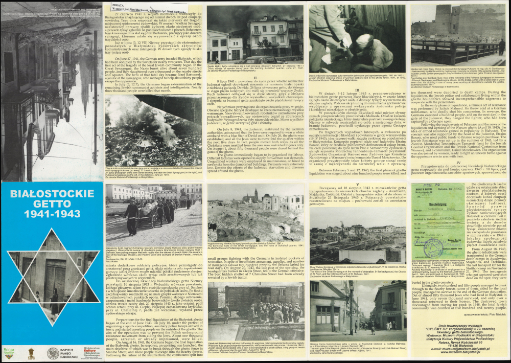
As mentioned in small print at the bottom of the legend, this map is based on the appearance and street names of the city in 1938, not the current day city plan, which differs noticeably. The extensive bilingual (Polish-English) legend at left notes the location of synagogues on the eve of the war, the gates and boundaries of the ghetto, twenty-six numbered sites within or nearby the ghetto, and explains color-shading used throughout for residential and industrial areas, parks, cemeteries, and other designations. Major streets and sites outside the ghetto are also labeled, including the Pałac Branickich, the rail line and station, the Biala River, and the Schulhof, the city's oldest Jewish neighborhood and the site of the magnificent Grand Synagogue, destroyed by the Nazis immediately after conquering the city. The verso contains photographs and text tracing the history of the ghetto from the moment the Nazis gained control of the city until the ghetto's final 'liquidation' and dissolution in August 1943.The Bialystok Ghetto
The Bialystok Ghetto was a Nazi-established Jewish ghetto in the city of Bialystok, in northeastern Poland, during the German occupation in World War II (1939 - 1945). It existed from July 1941 to August 1943 and was part of the broader Nazi policy of persecution, exploitation, and extermination of the Jewish population of prewar Poland. Prior to the Second World War, the city was one of the great centers of Jewish intellectual life in Eastern Europe (Jews outnumbered Gentiles in the city from the early 19th century until an administrative reorganization in 1919); by the end of the war, almost all the city's Jews had been killed.Bialystok lies within the portion of eastern Poland that was occupied by the Soviet Union in 1939, soon after the Nazi invasion of Poland from the west, and was incorporated into the Byelorussian Soviet Socialist Republic. Less than two years later, the Germans invaded the Soviet Union and the city came under German occupation, with its sizable Jewish population being immediately attacked and terrorized by German police battalions who were handmaidens of the Holocaust. Horrifically, following a common tactic at this stage of the Holocaust, the city's Great Synagogue was burned down with hundreds of Jews locked inside. In the following weeks, thousands more were killed in mass shootings in and around Bialystok by police battalions, Einsatzgruppe B, and associated units.
A month after occupying Bialystok and unleashing this terror, the Germans moved to establish the Bialystok Ghetto on July 26, 1941, following a model already being implemented in Warsaw. The Jewish area of the city was walled off, any non-Jewish Poles living there were expelled, and Jews from throughout the city and surrounding region were moved in, some 50,000 people in all, with up to three families sharing a single room. As in Warsaw, conditions were horrific, with forced labor operations set up and rations deliberately limited, leading to starvation and disease. Any disobedience was punished severely and publicly with shootings and hangings. In February 1943, the Nazis began shipping Jews of the Bialystok Ghetto to extermination camp. By the summer, news of the fate of the Warsaw Ghetto and of the Jews sent to extermination camps had reached the Bialystok Ghetto, leading to the formation of a resistance movement that, as in Warsaw, fought to the bitter end against the ghetto's 'final liquidation.' Also as in Warsaw, a small number of Jews managed to escape in the course of the uprising, but they represented only a small percentage of the Jews who had been through the Bialystok Ghetto.
This map represents an important evolution in Poland's understanding of the history of the Second World War and the Holocaust. In the Soviet era, the extermination of the vast majority of prewar Poland's Jewish population was minimized, as was the role of some Poles in aiding their persecution to emphasize collective national and international suffering. The victory of the Red Army and its allies in the Polish underground was glorified above all else. The fall of communism led to more open discussion alongside a surge in national pride, resulting in a contested discourse. While historians and museums, such as the Bialystok Museum of History, which helped produce this map, have explored the destruction of Poland's Jews in great detail, ascribing even partial blame to Poles or to prewar Polish Antisemitism is not only controversial but, since 2018, potentially illegal.
Publication History and Census
This map was prepared by the cartographic firm Atikart with the text edited by Piotr Niziołek, a historian who works at the Bialystok Museum of History (Muzeum Historyczne w Białymstoku), part of the Muzeum Podlaskie w Białymstoku. It is undated, but the Polish text at the bottom of the last panel on the verso at bottom-right explains that the map was prepared to accompany an exhibition called 'We were here' (Byliśmy tu) at the Muzeum Podlaskie w Białymstoku held on the 70th anniversary of the ghetto's liquidation, that is, 2013. The only institutional holding of the map in the OCLC is with the National Library of Poland, and the Muzeum Podlaskie w Białymstoku would also surely hold an example, but we are unaware of any other institutional holdings or market history.Cartographer
Atikart (c. 1995 - present) is a Polish cartographic firm specializing in tourist maps of Polish cities, regions, and national parks. Though based in Bialystok, the company primarily operates online, providing customers with a wide range of maps, globes, and charts for various regions of the world in Polish. More by this mapmaker...
Condition
Excellent. Light wear along original fold lines. Text and printed images on verso.
References
OCLC 912911513.