This item has been sold, but you can get on the Waitlist to be notified if another example becomes available.
1980 Manuscript Map and Pictorial View, Tug Fork Valley, West Virginia and Kentucky
Bicherville-armyengineers-1980$600.00

Title
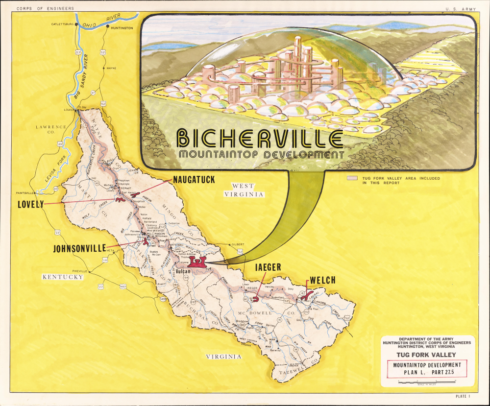
Tug Fork Valley Mountaintop Development Plan L, Part 27.5. / Bicherville Mountaintop Development.
1980 (undated) 13.75 x 16.5 in (34.925 x 41.91 cm) 1 : 316800
1980 (undated) 13.75 x 16.5 in (34.925 x 41.91 cm) 1 : 316800
Description
This is a highly unusual c. 1980 manuscript pictorial view of an imagined mountaintop community of 'Bicherville' in the Tug Fork Valley, along the border of West Virginia and Kentucky. Although resembling a space colony or experimental biodome, the conceived project was instead motivated by concerns about flooding and hoped to revive the mining industry in the area.
At the top is a wonderful, puzzling pictorial view of a conceptual mountaintop development called Bicherville that is encased in a biodome. The tall Space Age-style buildings are connected via passageways or tunnels that run through the buildings themselves. Smaller domes both surround and exist within the main large dome, while mountains, valleys, and forests can be seen surrounding the community.
At the same time, flooding has long been a major problem for communities along the Tug Fork River. In 1977, springtime floods inundated towns along the river and washed over Williamson, one of the largest settlements in the valley, prompting the Corps of Engineers to spend years expanding an existing but insufficient floodwall.
In the 1960s, mountaintop mining (also called mountaintop removal mining) was developed as a means of exploiting previously difficult-to-access coal and other resources in the Appalachian Mountains. The process seemed to offer a silver bullet for the region's woes - creating jobs and economic growth, opening flat land for development in a sea of otherwise steep terrain, and controlling the devastating floods that periodically impacted the region. (Early proponents of mountaintop mining argued that it reduced the likelihood of flooding by deliberately shaping the landscape.) Despite some promising early experiments, such as a high school for McDowell County built on a mountaintop mining site near Welch, West Virginia, these plans did not pan out as hoped. Though mountaintop mining has become widespread in Appalachia, it has not generally led to the development of picturesque new mountaintop towns, and certainly not of the utopian variety imagined here.
A Closer Look
The sheet consists of two main portions, both three-dimensional pastedowns: a map and a view of the proposed community of Bicherville. The map covers the Tug Fork River Valley in the borderlands between West Virginia, Kentucky, and Virginia, extending from the confluence of the Tug Fork River with the Ohio River near Catlettsburg, Kentucky, and Huntington, West Virginia, to Tazewell County, Virginia. Major highways and rivers are traced, while the counties adjacent to the Tug Fork River are outlined and depicted in more detail, including elevation shading, cities and towns, and smaller waterways. The area immediately along the Tug Fork River is shaded with vertical lines. Several settlements are red-shaded, indicating that they are proposed locations for mountaintop communities like that depicted above.At the top is a wonderful, puzzling pictorial view of a conceptual mountaintop development called Bicherville that is encased in a biodome. The tall Space Age-style buildings are connected via passageways or tunnels that run through the buildings themselves. Smaller domes both surround and exist within the main large dome, while mountains, valleys, and forests can be seen surrounding the community.
Attempt at an Explanation
Why build an Appalachian Space Age Biodome? The project appears to be inexplicable, but an exploration of the broader context provides some clarification. There were two major problems in the Tug Fork River Valley: flooding and the decline of the mining industry. Many towns along the river had sprung up with mines in the late 19th or early 20th century. But by the 1960s, traditional mining methods had extracted the easily accessible coal, and these towns were dying, with some (like Johnsonville) disappearing from the map altogether. Politicians such as longtime West Virginia Senator Robert Byrd (1917 - 2010) were desperate to find some relief for their constituents.At the same time, flooding has long been a major problem for communities along the Tug Fork River. In 1977, springtime floods inundated towns along the river and washed over Williamson, one of the largest settlements in the valley, prompting the Corps of Engineers to spend years expanding an existing but insufficient floodwall.
In the 1960s, mountaintop mining (also called mountaintop removal mining) was developed as a means of exploiting previously difficult-to-access coal and other resources in the Appalachian Mountains. The process seemed to offer a silver bullet for the region's woes - creating jobs and economic growth, opening flat land for development in a sea of otherwise steep terrain, and controlling the devastating floods that periodically impacted the region. (Early proponents of mountaintop mining argued that it reduced the likelihood of flooding by deliberately shaping the landscape.) Despite some promising early experiments, such as a high school for McDowell County built on a mountaintop mining site near Welch, West Virginia, these plans did not pan out as hoped. Though mountaintop mining has become widespread in Appalachia, it has not generally led to the development of picturesque new mountaintop towns, and certainly not of the utopian variety imagined here.
Publication History and Census
This perplexing work was produced c. 1980 by the U.S. Army Corps of Engineers Huntington District Regional Office, which was and remains primarily concerned with flood control. Although portions of the sheet are printed - such as the border, much of the map, and the title at bottom-right - the color-shading and the inset illustration at the top are done in manuscript applied to the sheet as three-dimensional pastedowns. The title, the notation ('Plate I'), and caption for the shading ('Tug Fork Valley Area included in this Report') all suggest that this work was intended to be included in a Corps of Engineers report. However, we have been unable to locate any government or military report referring specifically to Bicherville or a 'Plan L' for mountaintop development in the Tug Fork Valley. The Corps of Engineers' Huntington District did produce preliminary plans in the early 1980s for developments in the Tug Fork River Valley combining residential and commercial space with mountaintop mining, and these named some of the locations mentioned here (Iaeger, Welch, Naugatuck) as potential sites for such combined developments. In sum, this appears to have been a concept piece produced by the Corps of Engineers that never moved beyond the drafting stage. Perhaps a draughtsman for the Corps felt free to be creative, knowing that this was an early draft of a project that would take years to realize, if ever. In any event, as a manuscript map and view, it is an entirely unique piece, and certainly among the more curious maps we have come across.Condition
Very good. Manuscript plan on artboard. Includes two three-dimensional pastedowns.
References
U.S. Army Corps of Engineers, Tug Fork Valley Flood Damage Reduction Plan (VA,KY)Environmental Impact Statement Volume 13, (Corps of Engineers: Huntington, WV) 1982. Energy and Water Development Appropriations for 1983 : Hearings Before a Subcommittee of the Committee on Appropriations, House of Representatives, Ninety-seventh Congress, Second Session, Part 1, (Washington, D.C.: U.S. Government Printing Office) 1982.