1909 Lowe Bicycling Map of the Environs of Algiers, Algeria
BicyclingAlgiers-lowe-1909$650.00

Title
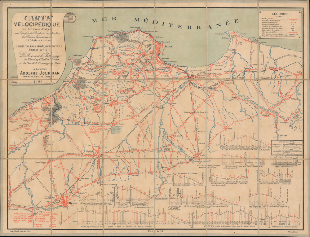
Carte Vélocipédique des Environs d'Alger.
1909 (dated) 20 x 26.25 in (50.8 x 66.675 cm) 1 : 100000
1909 (dated) 20 x 26.25 in (50.8 x 66.675 cm) 1 : 100000
Description
This is a 1909 Émile Lowe cycling map of the environs of Algiers, Algeria. The map documents the introduction of cycling to colonial Algeria and how, there, as elsewhere, cycling evolved into a popular pastime that encouraged the development of good roads, ultimately paving the way for the automobile age.
A Closer Look
The map depicts northern Algeria from the Mediterranean Sea to Blida. Cyclable roads with milage are highlighted in red overprinting, while uncyclable roads are marked in black.Cycling in Algeria
Bicycles arrived in Algrea sometime in the mid-1880s, when English aristocrats, wintering in Algeria introduced the novel contraption, the velocipede, to Algerian society, instigating a new popular pastime. In subsequent decades, cycling grew in popularity with the French colonial population, and as access to bicycles became more prevalent, immigrant communities and Algerians themselves began to enjoy cycling's social, athletic, and transportation benefits. By 1909, when this map was issued, the Union Vélocipédique Algérienne ran local clubs in Algiers and Oran organized amateur races, time trials, or long-distance rides.Publication History and Census
This map was originally drawn by Émile Lowe, engraved by J. Duvert, and published by P. Duvert in Algiers in 1899. Adolphe Jourdan published a 2nd edition in 1907 and a 3rd edition in 1909 (present example). We know of one surviving example of the 1899 edition, which is part of the collection at the Bibliothèque Nationale de France. One example of the 1907 edition is cataloged in OCLC at Harvard University. This is the only known surviving example of the 1909 edition.CartographerS
Émile Théodore Lowe (April 20, 1846 - July 23, 1921) was a German-born architect who lived in Algiers, Algeria. Born in Schwerin, Germany, Lowe married twice and was both his wives died before he did. His first marriage was to Ida Hélène Marie Bottchen and his second marriage was to Julie Euphrasie Wallez. More by this mapmaker...
Adolphe Dominique Jourdan (August 4, 1846 - August 15, 1916) was a printer, bookseller, and editor active in Algiers, Algeria. Born in Algiers, it is likely that Jourdan was born to French colonist parents, but that is unclear. He published books and maps of Algeria, Morocco, Tunisia, and other subjects. Jourdan was also active in local politics and civic life. He married Marie Dermineur. Learn More...
Condition
Very good. Dissected and mounted on original linen.