This item has been sold, but you can get on the Waitlist to be notified if another example becomes available, or purchase a digital scan.
1892 Roy View and Map of the Chicago World's Fair Columbian Exposition
BirdsEyeChicago-roy-1892$225.00

Title
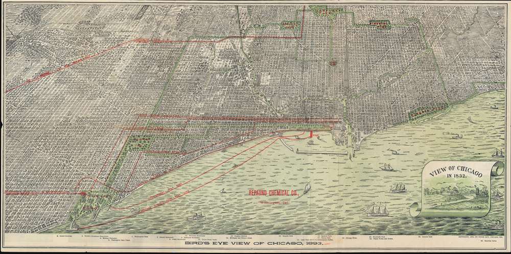
Bird's Eye View of Chicago, 1893.
1892 (dated) 15 x 30 in (38.1 x 76.2 cm)
1892 (dated) 15 x 30 in (38.1 x 76.2 cm)
Description
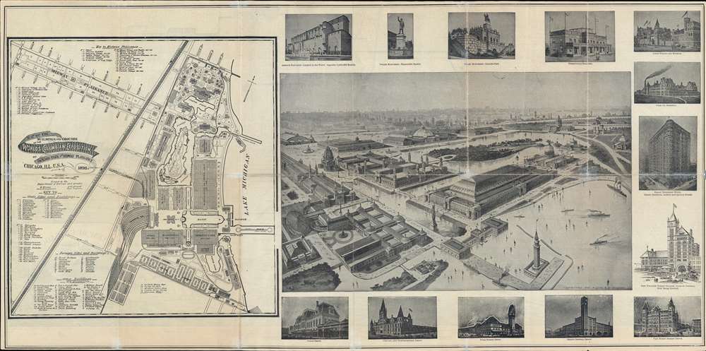
An uncommon 1892 promotional view of Chicago issued by Peter Roy in anticipation of the 1893 Chicago World's Fair or Columbian Exposition. This view is a promotional piece for the fair and is printed on both front (recto) and back (verso). The recto features an expansive view of Chicago before the major renovations intended to accommodate the explosion were complete. The verso features a map of the planed fair and an artist's conception of the completed fairgrounds.
City views were being produced in the United States as early as the 1830s, but the genre exploded after the American Civil War (1861 - 1865). Bridging the gap between maps and pictures, most 19th century American Bird's-eye views presented cities to the public from highpoints. Some were imagined, but others were drawn from hot-air balloons or nearby hills. The presentation, combining high elevation, commercial interest, and new printing technology created a uniquely American art form, as described by historian Donald Karshan,
The View
The view looks east on the city from a fictional high point above Lake Michigan. Grant Park and the Loop appear front and center. Coverage extends roughly from Jackson Park to Lincoln Park and extends inland roughly to Garfield Park. The Chicago greenbelt is illustrated boldly with green overprinting. Parks and railroad networks are highlighted in red overprinting. Although not evident here, within a year the area between Grant and Jackson Parks would be fully and expansively transformed to accommodate the 1893 Columbian Exposition.Verso Content
On the back or verso, there is a detailed map of the Columbian Exposition grounds - as proposed - by Chicago civil engineers Hermann Heinze and John W. Alvord. The map details the many buildings and exhibits planned for the fair. An artist's conception of what the fairgrounds would soon look like appears at right.1893 Columbian Exposition
The 1893 Columbian Exposition or Chicago World's Fair was a pivotal moment in the history of the United States. Chicago, keen to parade to the world its remarkable recovery from the disastrous 1871 Great Fire of Chicago, won the right to host the World's Fair over New York, Washington D.C., and St. Louis. During its six-month run, nearly 27,000,000 people attended the Columbian Exposition, correlating to roughly half the 1893 population of the United States. Its numerous displays and exhibits established conventions for architecture, design, and decorative arts, initiated a new era of American industrial optimism.Chicago Greenbelt
The park designers Frederic Law Olmstead and Calvert Vaux, more famous for New York's Central Park, created the Chicago park and boulevard system as a 26-mile ring of parks and garden boulevards. The network creates a loose ring that winds through the north, west, and south sides of Chicago. The neighborhoods along this historic stretch include Logan Square, Humboldt Park, Englewood, Back of the Yards, Lawndale, and Bronzeville. It reaches as far west as Garfield Park and turns southeast to Douglas Park. In the south, it reaches Washington Park and Jackson Park, including the Midway Plaisance, used for the 1893 Columbian Exposition. The park system on the National Register of Historic Places where it is reviewed,This ambitious system was created in response to the belief that it would not only help create healthful, accessible, and livable neighborhoods but would also spur residential real estate development in what was then the outskirts of the city. As anticipated, the park and boulevard system attracted real estate development and in the process created one of the city’s most recognizable and lasting urban features. The system is locally significant because, for the first time in Chicago, urban growth was thoughtfully planned and executed on a city-wide scale. The park and boulevard system not only provided a structure for orderly real estate development, it also provided an amenity that elevated the sophistication of the city by enriching both its visible character and its quality of life.
American Bird's-Eye City Views
The industry of Bird's-Eye view emerged in the United States in the middle part of the 19th century and coincided with the commercial development of lithographic printing. While before the rise of lithography, the ability to own and display artwork in the home was largely limited to the extremely wealthy, lithographic printing made it possible for everyone to own visually striking artwork. A robust trade developed in portraits of political leaders, allegorical and religious images, and city views.City views were being produced in the United States as early as the 1830s, but the genre exploded after the American Civil War (1861 - 1865). Bridging the gap between maps and pictures, most 19th century American Bird's-eye views presented cities to the public from highpoints. Some were imagined, but others were drawn from hot-air balloons or nearby hills. The presentation, combining high elevation, commercial interest, and new printing technology created a uniquely American art form, as described by historian Donald Karshan,
Some print connoisseurs believe that it was only with the advent of the full-blown city-view lithograph that American printmaking reached its first plateau of originality, making a historical contribution to the graphic arts. They cite the differences between the European city-view prints and the expansive American version that reflects a new land and a new attitude toward the land.The vogue for bird's-eye city views lasted from about 1845 to 1920, during which period some 2,400 city were thus portrayed, some multiple times. Although views were produced in many urban centers, the nexus of view production in the United States was Milwaukee, Wisconsin. The major American viewmakers were Stoner, Wellge, Bailey, Fowler, Hill Ruger, Koch, Burleigh, Norris, and Morse, among others.
Publication History and Census
This view was compiled and printed in 1892 by Peter (Pierre Joseph) Roy. There are two states. The present pamphlet edition and a premium presentation edition. The only known example of the presentation edition is at the Library of Congress (LC Panoramic Maps, 151). We have identified roughly 10 examples of this view, in the present edition, in institutional collections.Cartographer
Pierre Joseph Roy (February 3, 1869 - October 23, 1917), who often named himself 'Peter', was a French Canadian engraver and viewmaker based in Chicago in the second half of the 19th century. Roy emigrated to the United States with his family in 1870. His father, also Peter/Pierre Roy (1840 - ????), established himself as an engraver in the early 1870s partnering with with Anders Madsen Askevold (1842 - 1901) to found the Chicago Map Establishment. He left his firm in 1875, but by 1876 Roy partnered with Edmond Brown to publish under the imprint of 'Brown and Roy', 54 Reaper Block, Chicago. We believe Pierre Joseph may have inherited this operation. He reappears briefly in 1892 when he issued an impressive Bird's-Eye View of Chicago for the upcoming Columbian Exposition. As late as 1910 he is listed in the Chicago census as manager of a 'Print Shop.' More by this mapmaker...
Condition
Good. Minor edge wear along old fold lines. Minor verso reinforcement.
References
Library of Congress, G4104.C6A3 1893 .R6. Reps, John, Views and Viewmakers of Urban America (University of Missouri, Columbia, 1984), #859.