This item has been sold, but you can get on the Waitlist to be notified if another example becomes available, or purchase a digital scan.
1879 Newton Map of the Black Hills, South Dakota (Gold Rush)
BlackHills-newton-1879$325.00

Title
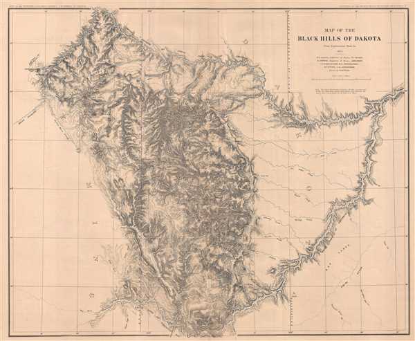
Map of the Black Hills of Dakota.
1879 (dated 1875) 30 x 36 in (76.2 x 91.44 cm) 1 : 253440
1879 (dated 1875) 30 x 36 in (76.2 x 91.44 cm) 1 : 253440
Description
This is an 1879 Henry Newton map of the Black Hills during the height of the Black Hills Gold Rush. The Back Hills are a spectacular mountain range in the northern plains states of South Dakota and Wyoming. Per Carl Wheat, the map depicts from 102 degrees 10 minutes to 105 degrees [west longitude] and from 43 degrees 15 minutes to 45 degrees [north latitude]. Contouring is employed as the basis of the map. A note is also included below the title and scale that 'The Sioux Reservation includes all the country east of the 103rd Meridian, except that which lies between the North and South Forks of the Cheyenne River.'
From a geographical standpoint, several rivers are depicted and labeled, including both the North and South Fork of the Cheyenne River, the White River, and the Big Cheyenne River. Several peaks, such as Terry's Peak and Custer's Peak, are labeled, along with numerous buttes.
Gold was discovered in the Black Hills in 1874 by the Black Hills Expedition, which was led by Lieutenant Colonel George Armstrong Custer, who would later meet his end at the Battle of Little Big Horn. An expedition, led by Henry Newton and Walter P. Jenney, was sent to investigate the uncharted regions of the Black Hills by the United States Geological Survey in response to this discovery and the ensuing gold rush. Created during the height of the Black Hills Gold Rush, this map was published in an atlas which accompanied a government report titled Topographic and geological atlas of the Black Hills of Dakota to accompany the report of Henry Newton, E.M. assistant geologist.The expedition, led by Walter P. Jenney, E.M., Per Wheat, who quoted J.S. Newberry
When presented to Congress its publication would have been immediately authorized except for a selfish and heartless opposition it encountered springing from the fear that it would betray the inaccuracy of previously published descriptions of the geology of the region. [A scarcely veiled crack at F. V. Hayden.] This opposition cost Mr. Newton his life, for when Congress deferred action on his report till another session he determined to employ a part of the interval in revisiting the Black Hills, repeating some of his observations and recording the results of the rapidly-developing mining industry. While engaged in this work he was attacked by typhoid fever, and died at Deadwood, August 5, 1877.
This map was drawn by Emil Mahlo and bears the names of Walter Proctor Jenney, Henry Newton, V. T. M'Gillicuddy, and H. P. Tuttle, all of whom were members of the expedition. The map was published by Julius Bien in New York, 1879.
CartographerS
The United States Geological Survey (1878 - Present), aka the U.S.G.S., is a scientific agency of the United States government, which was founded in 1879. USGS scientists study the landscape of the United States, its natural resources, and the natural hazards that threaten it. The organization has four major science disciplines: biology, geography, geology, and hydrology. It is a bureau of the United States Department of the Interior and is the department's only scientific agency. More by this mapmaker...
Julius (Julien) Bien (September 27, 1826 - December 21, 1909) was a German-Jewish lithographer and engraver based in New York City. Bien was born in Naumburg, Germany. He was educated at the Academy of Fine Arts, Cassell and at Städel's Institute, Frankfurt-am-Main. Following the suppression of the anti-autocratic German Revolutions of 1848, Bien, who participated in the pan-German movement, found himself out of favor in his home country and joined the mass German immigration to the United States. Bien can be found in New York as early as 1849. He established the New York Lithographing, Engraving & Printing Company in New York that focused on the emergent chromo-lithograph process - a method of printing color using lithographic plates. His work drew the attention of the U.S. Government Printing Office which contracted him to produce countless government maps and surveys, including the Pacific Railroad Surveys, the census, numerous coast surveys, and various maps relating to the American Civil War. Bien also issued several atlases both privately and in conjunction with a relation, Joseph Bien. At the height of his career Bien was elected president of the American Lithographers Association. After his death in 1909, Bien's firm was taken over by his son who promptly ran it into insolvency. The firm was sold to Sheldon Franklin, who, as part of the deal, retained the right to publish under the Julius Bien imprint. In addition to his work as a printer, Bien was active in the New York German Jewish community. He was director of the New York Hebrew Technical Institute, the New York Hebrew Orphan Asylum, and president of the B'nai B'rith Order. Learn More...
Source
Newton, Henry, Topographical And Geological Atlas of The Black Hills of Dakota (New York: Julien Bien) 1879.
Condition
Very good. Verso reinforcement of centerfold separation. Blank on verso.
References
Wheat, C. I., Mapping of the Transmississippi West, 1540 – 1861, V: 329-31. Rumsey 2083.002. OCLC 56317221.