This item has been sold, but you can get on the Waitlist to be notified if another example becomes available.
1879 Newton Atlas of the Black Hills, South Dakota; Gold Rush
BlackHillsAtlas-newton-1879$3,750.00
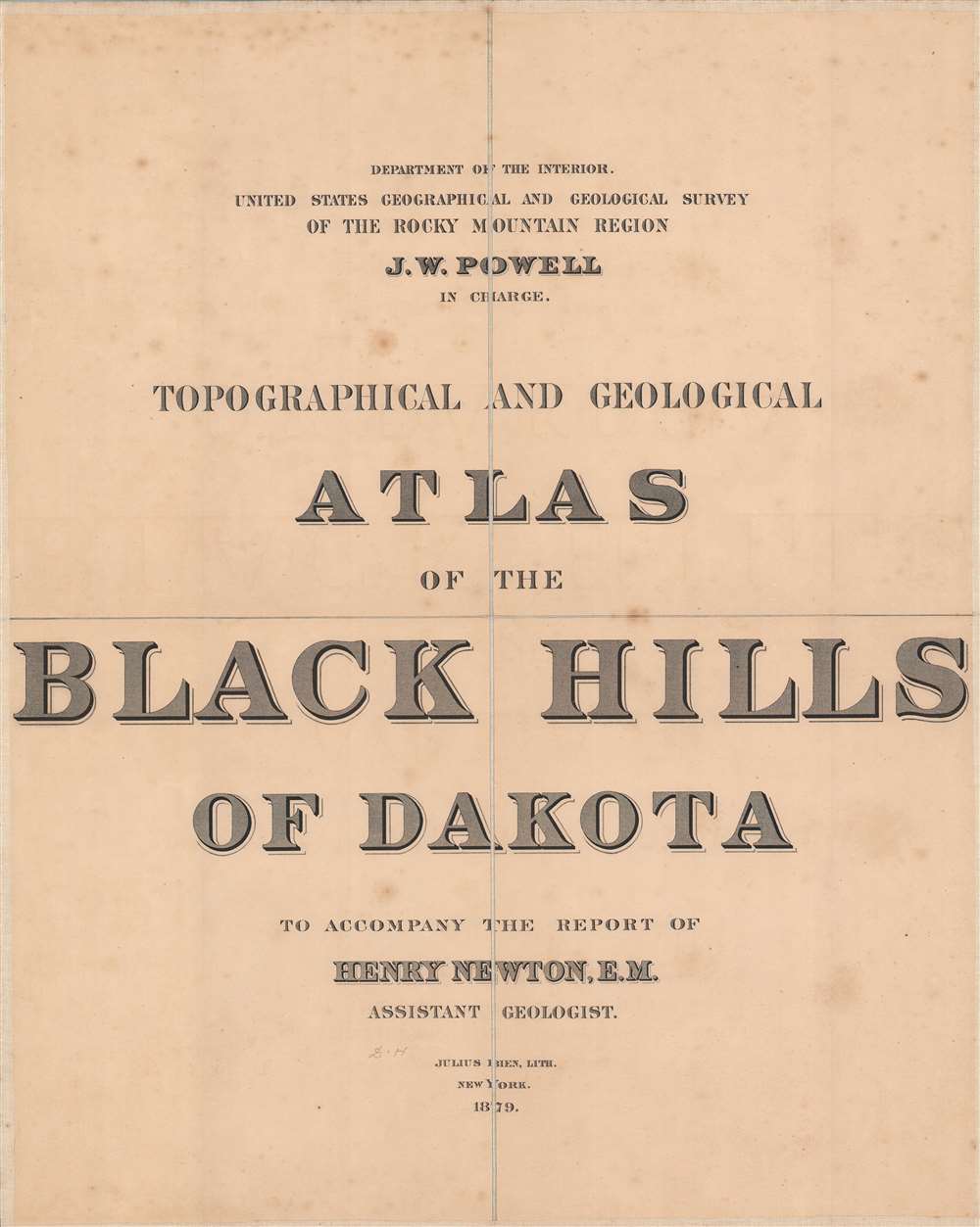


Title
Topographical and Geographical Atlas of the Black Hills of Dakota.
1879 (dated) 31.25 x 38 in (79.375 x 96.52 cm) 1 : 253440
1879 (dated) 31.25 x 38 in (79.375 x 96.52 cm) 1 : 253440
Description
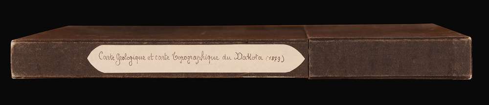
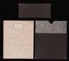
This is an 1879 Henry Newton geological atlas of the Black Hills, Dakota Territory (now South Dakota) published during the height of the Black Hills Gold Rush. Consisting of two maps and one view, the atlas provides some of the earliest detailed surveys of the region and particularly its geology, a matter of critical importance to miners. The present example, unlike any other we've seen, is handsomely dissected, laid on linen, and accompanies a custom original slipcase.
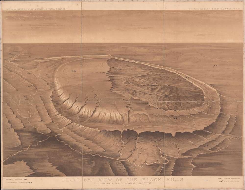
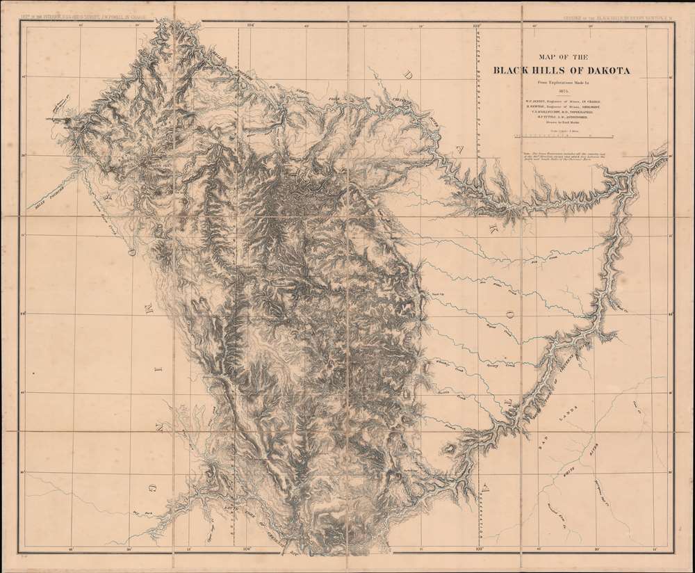
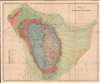
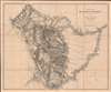
The 'Map of the Black Hills of Dakota' covers the same territory as the previous map without the color shading. Finally, the 'Bird's Eye View of the Black Hills' was designed by Newton to illustrate the bizarre regional geography. Rather innovatively, birds are used to identify various types of stone, for example, a single bird flying downward indicates Archean Schists.
The presence of gold and the need to transport it presented motives and opportunities for audacious robberies. By 1876, Deadwood was a den of crime and violence, consisting of 10,000 - 25,000 settlers. The lawlessness of Deadwood and other settlements was heightened by the fact that they were built illegally on Indian territory (the Great Sioux Reservation) and therefore outside of U.S. jurisdiction. Frontier justice prevailed and lynching was common.
Even more problematically, the Black Hills, including Deadwood, had been granted in the 1868 Treaty of Fort Laramie to the Sioux (Lakota) people, who considered the lands sacred, as did the Cheyenne. These factors created a highly volatile situation that devolved into the Great Sioux War of 1876 - 1877. One of the most significant engagements was the Battle of Little Bighorn, where Custer's army was ambushed and overwhelmingly defeated by an allied Indian force. In the end though, the tremendous resources of the U.S. Army and their ability to isolate Indian encampments, forcing them to starve or surrender, led to the annexation of the Black Hills into the Dakota Territory and the removal of the Sioux to smaller reservations outside the gold-producing regions.
Meanwhile, the gold rush continued, but at most of the sites gold was chemically bound to rock in a way that made it very difficult to extract. Only the Homestake Mine at Lead, just outside Deadwood, proved capable of supporting the simpler free milling. This single mine proved so rich that it continued to function into the 21st century, becoming the largest and deepest mine in North America and at times providing as much as 10% of the world's gold supply.
The Atlas
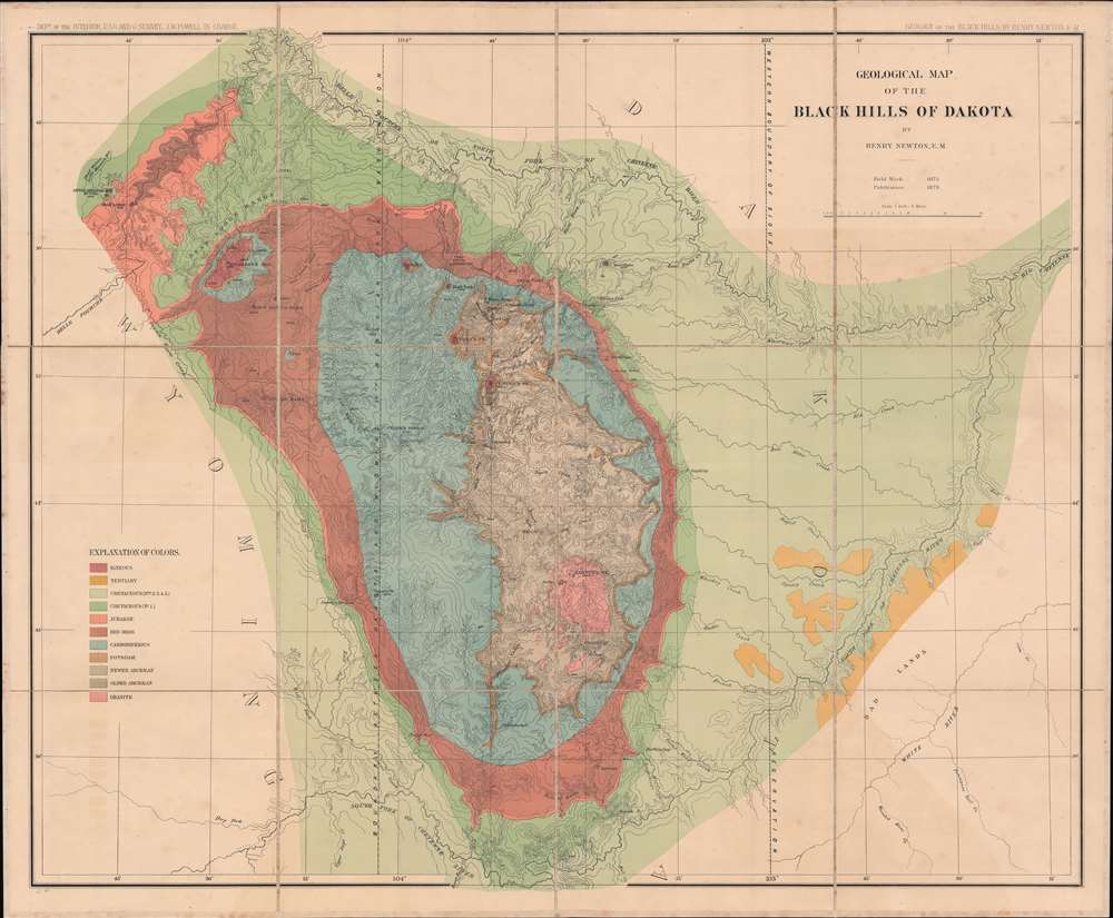
The Black Hills are a spectacular mountain range in the northern plains states of South Dakota and Wyoming. The 'Geological Map of the Black Hills of Dakota' reflects the stunning beauty of the landscape by using chromolithograph color to represent geologic formations. Rivers and creeks are noted, along with buttes (elevation indicated using hachures), latitude, longitude, and the boundaries between the Dakota and Wyoming Territories and of the Sioux Reservation.The 'Map of the Black Hills of Dakota' covers the same territory as the previous map without the color shading. Finally, the 'Bird's Eye View of the Black Hills' was designed by Newton to illustrate the bizarre regional geography. Rather innovatively, birds are used to identify various types of stone, for example, a single bird flying downward indicates Archean Schists.
The Black Hills Gold Rush and the Great Sioux War
Although it may have been discovered earlier, the presence of gold in the Black Hills region of the Dakota Territory was given wide publicity in the wake of the 1874 Black Hills Expedition, led by Lt. Col. George Armstrong Custer. The following year, the United States Geological Survey sent a group of scientists and surveyors led by Henry Newton and Walter P. Jenney to investigate the uncharted Black Hills and seek rumore gold deposits. Both this group and others found large deposits of gold and prospectors flocked to the region, in particular the boomtown of Deadwood, which became the center of the gold rush (portrayed in the acclaimed HBO television series and later film Deadwood).The presence of gold and the need to transport it presented motives and opportunities for audacious robberies. By 1876, Deadwood was a den of crime and violence, consisting of 10,000 - 25,000 settlers. The lawlessness of Deadwood and other settlements was heightened by the fact that they were built illegally on Indian territory (the Great Sioux Reservation) and therefore outside of U.S. jurisdiction. Frontier justice prevailed and lynching was common.
Even more problematically, the Black Hills, including Deadwood, had been granted in the 1868 Treaty of Fort Laramie to the Sioux (Lakota) people, who considered the lands sacred, as did the Cheyenne. These factors created a highly volatile situation that devolved into the Great Sioux War of 1876 - 1877. One of the most significant engagements was the Battle of Little Bighorn, where Custer's army was ambushed and overwhelmingly defeated by an allied Indian force. In the end though, the tremendous resources of the U.S. Army and their ability to isolate Indian encampments, forcing them to starve or surrender, led to the annexation of the Black Hills into the Dakota Territory and the removal of the Sioux to smaller reservations outside the gold-producing regions.
Meanwhile, the gold rush continued, but at most of the sites gold was chemically bound to rock in a way that made it very difficult to extract. Only the Homestake Mine at Lead, just outside Deadwood, proved capable of supporting the simpler free milling. This single mine proved so rich that it continued to function into the 21st century, becoming the largest and deepest mine in North America and at times providing as much as 10% of the world's gold supply.
The Newton-Jenny Party
Although details are hazy, the Newton-Jenney Party appears to have been a more ragtag outfit than one might imagine from a government geological survey. Its military escort, originally meant to be led by Custer, replaced by Col. Richard I. Dodge, may have included Calamity Jane, who was present in Deadwood at the time. Its advisors included California Joe Milner, serial miner and possible murderer, and Valentine McGillycuddy (credited here as 'V.T. M'Gillycuddy, M.D., topographer'), a surgeon and later an important Indian Agent who advocated better treatment of Native Americans but was dismissed from his position amid charges of fraud. Soon after the expedition's completion, Dodge, who wrote several books while also soldiering, published The Black Hills: A Minute Description of the Routes, Scenery, Soil, Climate, Timber, Gold, Geology, Zoölogy, etc.. Meanwhile, as the surveys questioned the accuracy of earlier descriptions of the region by respected geologist F. V. Hayden, the expedition's conclusions faced scrutiny. Newton returned to the field to verify their results, but fell ill with typhoid fever and died in Deadwood in August 1877. It was only in 1879 that Congressional delays and opposition had sufficiently cleared for the atlas to be published.Publication History and Census
This atlas was published to accompany the 1879 report of Henry Newton et al, Report on the geology and resources of the Black Hills of Dakota. Aside from Newton and Walter P. Jenney, contributors included Valentine McGillycuddy, H.P. Tuttle, and Emil Mahlo. The maps were lithographed by Julius Bien in New York. The entire atlas is held by roughly twenty institutions worldwide, while the individual maps are sometimes cataloged separately in the OCLC. The present dissected and boxed example is unique, likely made for a French person of influence.CartographerS
The United States Geological Survey (1878 - Present), aka the U.S.G.S., is a scientific agency of the United States government, which was founded in 1879. USGS scientists study the landscape of the United States, its natural resources, and the natural hazards that threaten it. The organization has four major science disciplines: biology, geography, geology, and hydrology. It is a bureau of the United States Department of the Interior and is the department's only scientific agency. More by this mapmaker...
Julius (Julien) Bien (September 27, 1826 - December 21, 1909) was a German-Jewish lithographer and engraver based in New York City. Bien was born in Naumburg, Germany. He was educated at the Academy of Fine Arts, Cassell and at Städel's Institute, Frankfurt-am-Main. Following the suppression of the anti-autocratic German Revolutions of 1848, Bien, who participated in the pan-German movement, found himself out of favor in his home country and joined the mass German immigration to the United States. Bien can be found in New York as early as 1849. He established the New York Lithographing, Engraving & Printing Company in New York that focused on the emergent chromo-lithograph process - a method of printing color using lithographic plates. His work drew the attention of the U.S. Government Printing Office which contracted him to produce countless government maps and surveys, including the Pacific Railroad Surveys, the census, numerous coast surveys, and various maps relating to the American Civil War. Bien also issued several atlases both privately and in conjunction with a relation, Joseph Bien. At the height of his career Bien was elected president of the American Lithographers Association. After his death in 1909, Bien's firm was taken over by his son who promptly ran it into insolvency. The firm was sold to Sheldon Franklin, who, as part of the deal, retained the right to publish under the Julius Bien imprint. In addition to his work as a printer, Bien was active in the New York German Jewish community. He was director of the New York Hebrew Technical Institute, the New York Hebrew Orphan Asylum, and president of the B'nai B'rith Order. Learn More...
Source
Newton, Henry, Topographical And Geological Atlas of The Black Hills of Dakota, (New York: Julien Bien) 1879.
Condition
Very good. Light foxing on all three maps, offsetting on the chromolithograph geological map. Dissected and laid on linen. Accompanied by fine original slipcase with French title on the spine.
References
Wheat, C. I., Mapping of the Transmississippi West, 1540 – 1861, V: 329-31. Rumsey 2083. OCLC 965505415, 923583238, 249131340, 556619296.