This item has been sold, but you can get on the Waitlist to be notified if another example becomes available, or purchase a digital scan.
1939 Brooklyn-Manhattan Transit Map of the BMT Subway for the 1939 World's Fair
BMTNYWorldsFair-bmt-1939$125.00

Title
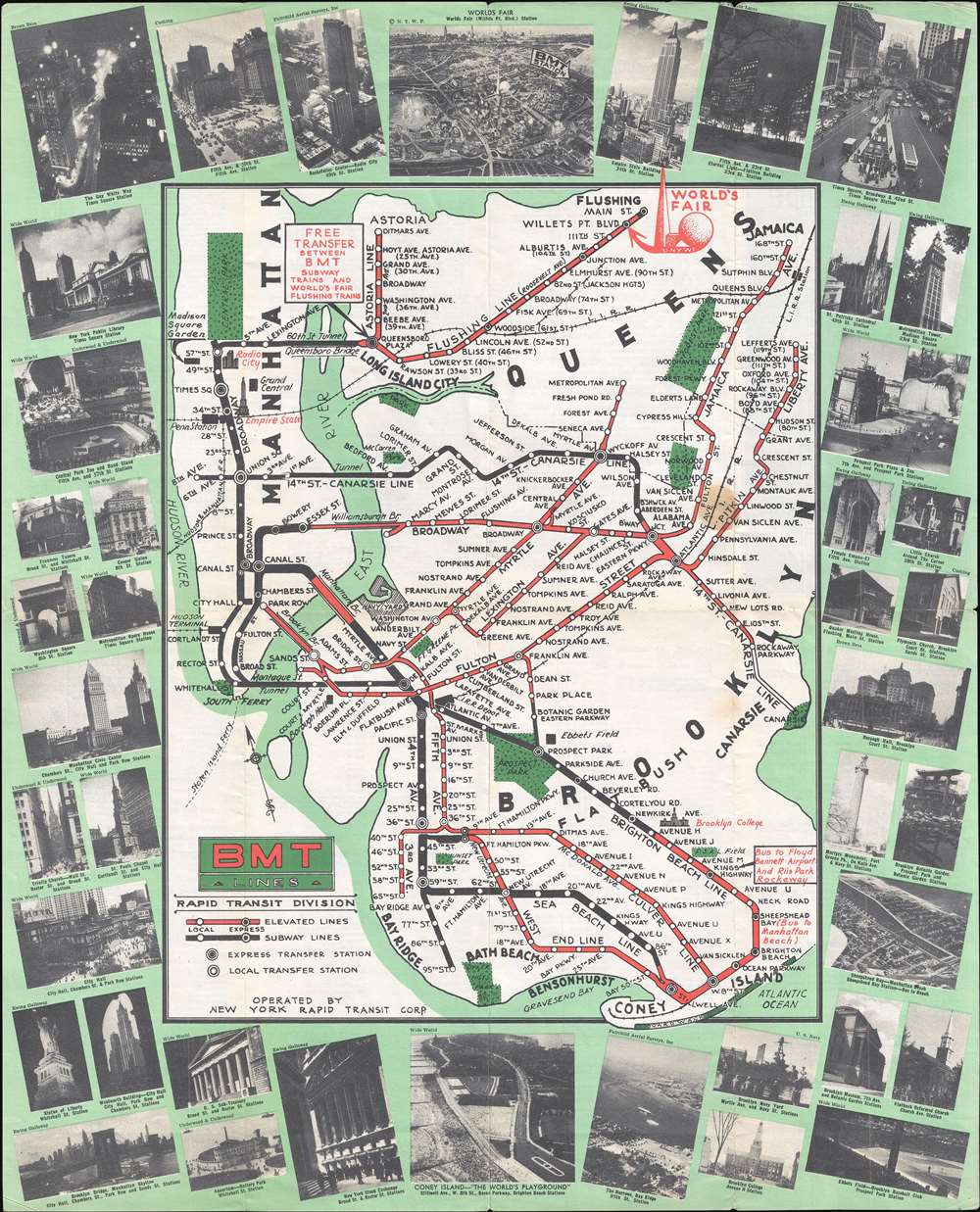
BMT Lines Rapid Transit Division.
1939 (undated) 19.875 x 16.125 in (50.4825 x 40.9575 cm) 1 : 60720
1939 (undated) 19.875 x 16.125 in (50.4825 x 40.9575 cm) 1 : 60720
Description
This is a 1939 Brooklyn-Manhattan Transit Corporation (BMT) map of the BMT subway system promoting ridership to get to the 1939 New York World's Fair. The map depicts the region from Manhattan to Jamaica in Queens and from the East River to Coney Island. Very few locations around the city are labeled, although a few, such as the Empire State Building, Radio City Music Hall, Brooklyn College are illustrated in profile. The whole is surrounded by a green border overlaid by photographs of numerous New York City landmarks, including the Empire State Building, Coney Island, Rockefeller Center, Times Square, the New York Public Library, and Coney Island.
History of the BMT
The BMT was incorporated in 1923 to take over the assets of the Brooklyn Rapid Transit Company, which went bankrupt in 1919. The system blended subway lines and elevated lines, which this map differentiates through color. Express and local station transfers are also differentiated, and each stop along all the lines is labeled. The Long Island Railroad is also illustrated, since it connected to the BMT system at Atlantic Avenue in Brooklyn and at Woodside in Queens.1939 New York World's Fair
The New York World's Fair is, of course, highlighted by the Trylon and Perisphere, the symbols of the fair, in the upper-right corner marking the Willets Point Boulevard station as the correct stop for getting to the fair. A bird's eye view of the World's Fair, is, of course, featured at the center of the top border.Publication History
This map was created and published by the Brooklyn-Manhattan Transit Corporation and printed by The Tabard Press, Inc. in 1939.Condition
Very good. Even overall toning. Light soiling. Verso repairs to fold separations and at fold intersections. Text on verso.