1639 / 1680 Jansson Map of Bohemia
Bohemia-jansson-1639$650.00

Title
Bohemia.
1639 (undated) 16 x 18.5 in (40.64 x 46.99 cm) 1 : 760000
1639 (undated) 16 x 18.5 in (40.64 x 46.99 cm) 1 : 760000
Description
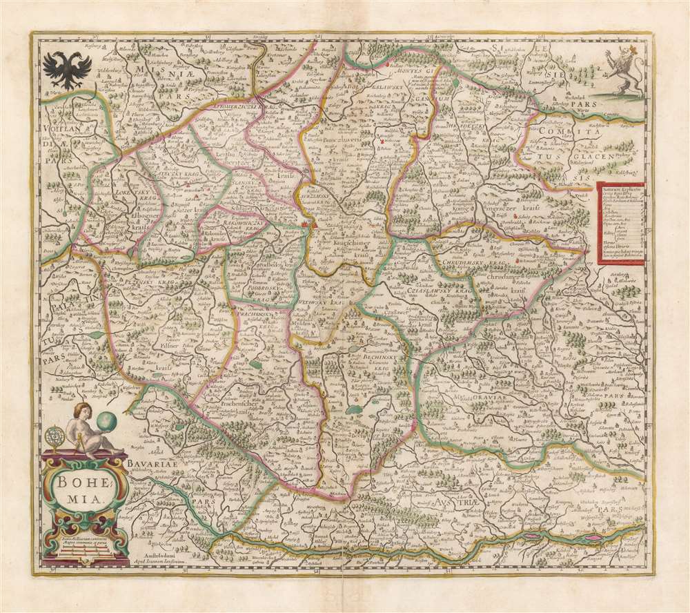
This is a beautiful, original-color 1680 example of Jan Jansson's map of Bohemia, the modern-day Czech Republic, and parts of neighboring Austria, Bavaria, Germany, Poland, and Moravia.
A Closer Look
The Danube River forms, in large part, the southern border of the map. Vienna is identified. A legend on the right explains symbols used to indicate forts, cities, and monasteries. Mines are identified as well, with specific symbols distinguishing between gold, silver, tin, and iron. The Giant Mountains are illustrated pictorially and named. Likewise, great forests appear and are identified. The coats of arms of the Holy Roman Empire and the Kingdom of Bohemia are displayed in the upper corners. An attractive cartouche, surmounted with a putto holding a globe and a cartographers' compass, contains the map's title and scales.Publication History and Census
This map was engraved for inclusion in Jansson's atlases, first appearing in the French edition of 1639. This example, without verso text, corresponds to the 1680, five-volume Jansson Atlas, which lacked text, containing only the maps. We do not see complete examples of this edition in institutional collections. The separate map we see in nine OCLC listings, in various editions. The map comes on the market from time to time.Cartographer
Jan Jansson or Johannes Janssonius (1588 - 1664) was born in Arnhem, Holland. He was the son of a printer and bookseller and in 1612 married into the cartographically prominent Hondius family. Following his marriage he moved to Amsterdam where he worked as a book publisher. It was not until 1616 that Jansson produced his first maps, most of which were heavily influenced by Blaeu. In the mid 1630s Jansson partnered with his brother-in-law, Henricus Hondius, to produce his important work, the eleven volume Atlas Major. About this time, Jansson's name also begins to appear on Hondius reissues of notable Mercator/Hondius atlases. Jansson's last major work was his issue of the 1646 full edition of Jansson's English Country Maps. Following Jansson's death in 1664 the company was taken over by Jansson's brother-in-law Johannes Waesberger. Waesberger adopted the name of Jansonius and published a new Atlas Contractus in two volumes with Jansson's other son-in-law Elizée Weyerstraet with the imprint 'Joannis Janssonii haeredes' in 1666. These maps also refer to the firm of Janssonius-Waesbergius. The name of Moses Pitt, an English map publisher, was added to the Janssonius-Waesbergius imprint for maps printed in England for use in Pitt's English Atlas. More by this mapmaker...
Source
Jansson, J., Atlas, (Amsterdam), 1680.
Condition
Very good. Centerfold mend at bottom margin. Few filled wormholes with virtually no loss. Fine original hand color.
References
OCLC 956960553. Van der Krogt, P. C. J., Koeman's Atlantes Neerlandici, 2850:1B.3.