1587 Ortelius Map of Bohemia in Superb Original Color
Bohemia-ortelius-1570$750.00

Title
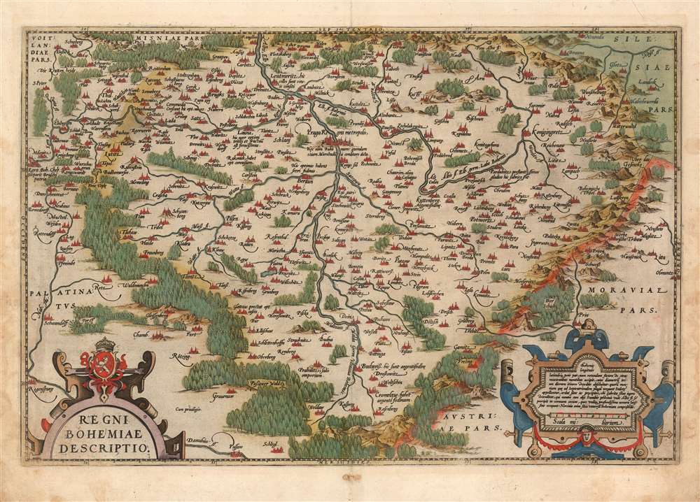
Regni Bohemiae Descriptio.
1570 (undated) 13 x 20 in (33.02 x 50.8 cm) 1 : 700000
1570 (undated) 13 x 20 in (33.02 x 50.8 cm) 1 : 700000
Description
This is Ortelius' 1570 map of Bohemia, in a beautiful, original-color example from the 1587 French edition of Theatrum Orbis Terrarum, the first modern atlas. It is derived from the unobtainable, Leipzig-published, 1568 Johann Criginger (1521 - 1571) map, which was to date the best map of Bohemia available. Like the Criginger, Ortelius' map is oriented to the north, showing the Kingdom of Bohemia surrounded by pictorially-represented forests and forbidding mountains. Cities and towns are pictorially shown to represent their respective sizes. Ortelius' map is embellished with two handsome, strapwork cartouches; the title cartouche is surmounted with the Bohemian coat-of-arms.
Publication History and Census
The map was produced for inclusion in Ortelius' Theatrum Orbis Terrarum, appearing in the work through its entire run from 1570 to 1641. Based on the verso text, this example corresponds to the 1587 French edition of Ortelius' atlas. Van den Broecke identifies two states to this work, the second of which appears 'from 1592 onwards (or possibly earlier)' based primarily on changes in cartouche hachure. Scrutiny of this and other examples suggest that plate wear and frequent minute retouching conspire to produce a greater variety of states than has been recorded, though none of the changes appear to be more than cosmetic might be considered 'pointless minutiae'. Van den Broecke estimates that approximately 8225 copies of this map were printed; as a rule of thumb perhaps one of ten survive. Consequently, the map is well represented in institutional collections and appears on the market with some regularity, albeit with wild variations in condition and quality.CartographerS
Abraham Ortelius (April 14, 1527 - June 28, 1598) also known as Ortels, was a cartographer, geographer, and cosmographer of Brabant, active in Antwerp. He was the creator of the first modern atlas, Theatrum Orbis Terrarum and is a seminal figure in the history of cartography. Along with Gerard Mercator and Gemma Frisius, he was a founder of the Netherlandish school of cartography. His connections with Spain - culminating in his 1575 appointment as Royal Cartographer to King Phillip II of Spain - gave him unmatched access to Spanish geographical knowledge during a crucial period of the Age of Discovery. Ortelius was born in 1527 in Antwerp. In 1547 he entered the Antwerp Guild of Saint Luke as an illuminator of maps. He began trading in books, prints, and maps, traveling regularly to the Frankfurt book and print fair, where in 1554 he met Mercator. He accompanied Mercator on journeys throughout France in 1560 and it was at this time, under Mercator's influence, that he appears to have chosen his career as a scientific geographer. His first published geographic work appeared in 1564, an eight-sheet cordiform world map. A handful of other maps preceded the 1570 publication of the first edition of the Theatrum Orbis Terrarum, which would prove to be his life work. Appearing with but 53 maps in its first edition, Ortelius' work expanded with new maps added regularly. By 1592, it had 134 maps. Many of Ortelius' maps remained the standard for nearly a century. He traveled extensively, but his genius was as a compiler, locating the best informed maps on which to base his own. His contacts throughout Europe and extending even (via the Portuguese) to the Far East were formidable. Moreover, many of his maps were based on his own scholarship, particularly his historical works. His theories of geography were particularly ahead of his time with respect to the notion of continental drift, the possibility of which he mused on as early as 1596, and which would be proven correct centuries later.
In a sense his greatest achievement was his successful navigation of the religious and political violence endemic to his city throughout his adult life: The Dutch Revolt, or Eighty Years' War (1568 - 1648), fully embroiled Antwerp. Although outwardly and officially recognized as Catholic (Arias Montanus vouched for Ortelius' Catholic orthodoxy prior to his appointment as Royal Geographer), Ortelius was able to separate himself from the religious furor which characterized the war in the low countries. Ortelius showed a glimpse of himself in a letter to a friend, regarding humanist Justus Lipsius: 'I do not know whether he is an adherent of the Pope or a Calvinist, but if he has ears to hear, he will neither be one nor the other, for sins are committed on both sides'. Ortelius' own explorations of Biblical history in his maps, and the Christogram contained in his own motto, suggest him to be a religious man, but his abjuration of political religious authorities mark him as an individualist. His tombstone at St Michael's Præmonstratensian Abbey in Antwerp bears the inscription, Quietis cultor sine lite, uxore, prole. ('served quietly, without accusation, wife, and offspring.') More by this mapmaker...
Johann Criginger (1521 - December 27, 1571) was a German Lutheran pastor, writer and cartographer. He was a student at the University of Wittenburg, transferring later to the University of Leipzig and in 1541 to the University of Tübingen. He became a teacher in Crimmitschau, but then returned to Wittenberg, whence he graduated in 1544. 1547 found him as court preacher of Count Lorenz Schlick in Žlutice. By 1548 he was a clergyman in Marienberg, where he became archdeacon in 1551. In 1559 he became a pastor in the Church of the Virgin Mary, holding that position until his death. Not only a churchman, Criginger was also a cartographer. He is most remembered for his 1568 Bohemiae regni nova chorographica Descriptio, which provided the source for Abraham Ortelius' Regni Bohemia Descriptio. (Criginger's map now exists only in two known copies. Learn More...
Source
Ortelius, A., Theatrum Orbis Terrarum, (Antwerp: Ortelius) 1587.
Abraham Ortelius' magnum opus, Theatrum Orbis Terrarum, was the world's first regularly produced atlas, which 'set the standards for later atlases . . . It was the first undertaking of its kind to reduce the best available maps to an uniform format.' (Koeman) A modestly-sized work of fifty-three maps in its first edition of May 1570, it was an immediate success: there were three further editions that year, and the work remained in print for a total of 32 editions, the last of which was 1641, well after its author's 1598 death. Ortelius added to his atlas constantly, and by 1595 the Theatrum contained 147 maps. Ortelius is renowned generally as an editor, and indeed much of the Theatrum is compiled from a variety of sources: in such cases, Ortelius was scrupulous in naming his sources. But Ortelius was also a mapmaker in his own right: many of his maps are a distillation of various sources into his own work, and there were many maps - particularly in his atlas of Biblical and ancient history Parergon - which were entirely Ortelius' work. In his role as an editor, Ortelius followed in the footsteps of Munster, whose Cosmographia was, until Ortelius, the best window on the world for the curious European reader. In terms of the artistry of his maps, Ortelius oversaw the first great flourishing of copperplate engraving in the service of cartography to occur in Northern Europe. Ortelius' work provided the model for the atlases of Mercator, Hondius, Blaeu and all their progeny in the 17th century - many of whom were to produce faithful editions of Ortelius' maps in their own productions.
Condition
Very good. Old reinforcement to lower corners with an unobtrusive marginal mend. Reinforced bottom centerfold. Rich original color.
References
Van den Broecke 101. OCLC 165993723 (1570).