This item has been sold, but you can get on the Waitlist to be notified if another example becomes available, or purchase a digital scan.
1729 Homann Map of the coastal Borderland of Norway and Sweden
Bohuslan-homann-1729$300.00

Title
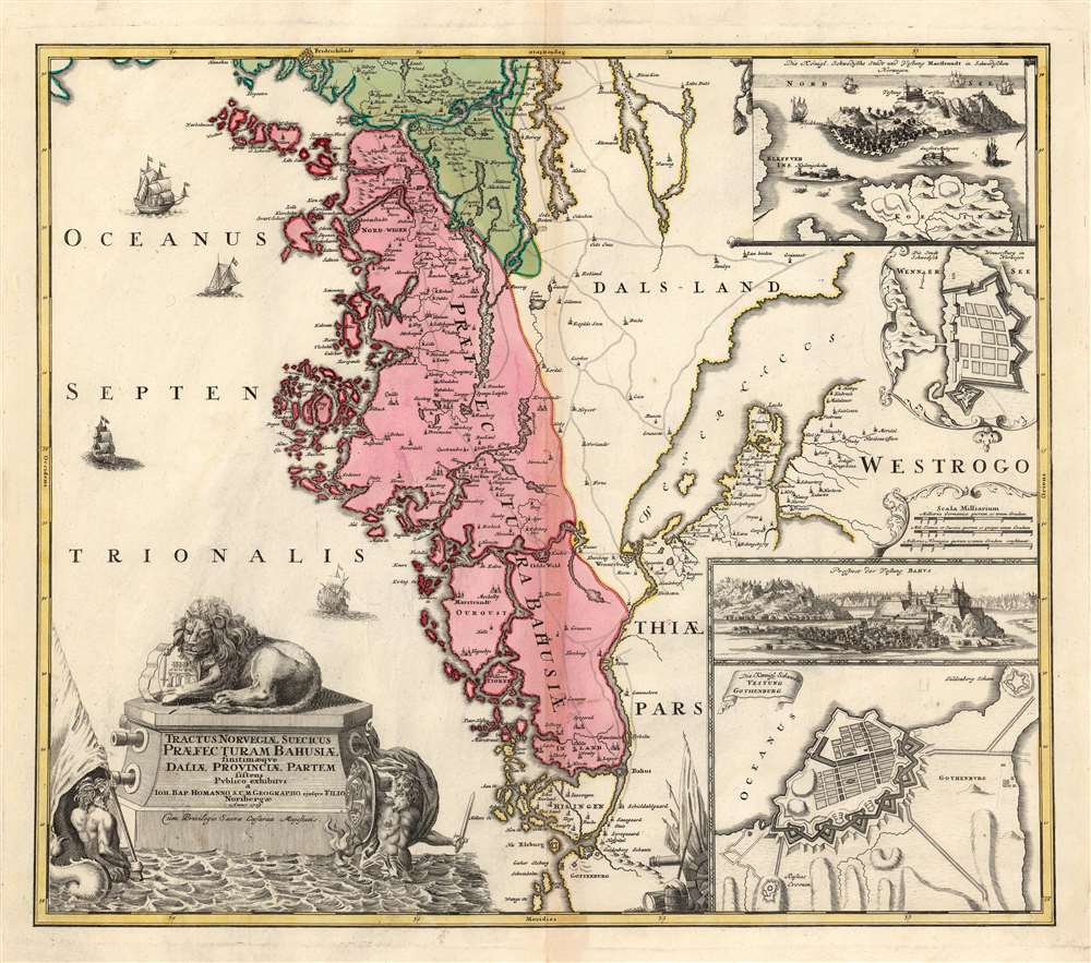
Tractus Norvegiae Suecicus Praefecturam Bahusiae.
1729 (dated) 18.75 x 21.75 in (47.625 x 55.245 cm) 1 : 450000
1729 (dated) 18.75 x 21.75 in (47.625 x 55.245 cm) 1 : 450000
Description
This is a detailed and elegant map, engraved in 1729 by Johann Christoph Homann, of the Swedish province of Bohuslän, and parts of Dalsand and of Västergötland on the coastal border of Sweden and Norway. After Sanson's comparatively rudimentary Gouvernement de Bahus of 1668, this is the first map to focus on this region in detail.
A Closer Look
The map covers the North Sea coast from Gothenburg to the Norwegian fortress city of Fridrichstadt. There are two inset views - the fortified island of Marstrant, and the castle of Bahus. (The latter derived from a 1697 view by Samuel von Pufendorf.) Additionally, two inset plans detail the fortifications at Gothenburg and Wennersburg. A martial cartouche presents a stylized fortress in the water, flanked by armed mermen. One, brandishing a sword, carries a shield emblazoned with the Swedish arms. Surmounting the cartouche, a lion (representing Sweden) rests possessively atop the arms of Bohuslän, characterizing Sweden's attitude towards this borderland with Norway. (Bohuslän had been Norwegian territory until the 1658 treaty of Roskilde, in which Denmark and Norway were forced to cede the county and Skåneland to Sweden following the Second Northern War.) The map clearly evokes the provinces island-strewn coast yet understates the approximately three thousand islands that make up the Gothenburg archipelago. In the eastern part of the map, between Dalsand and of Västergötland, is Lake Vänern, the largest in Europe.Publication History and Census
This map may have been engraved by the elder Homann, but it was completed and published in 1729 by his son Johann Christoph for inclusion in the Homann atlases. We see only a single state of this map, of which perhaps twenty are cataloged in institutional collections.Cartographer
Johann Baptist Homann (March 20, 1664 - July 1, 1724) was the most prominent and prolific map publisher of the 18th century. Homann was born in Oberkammlach, a small town near Kammlach, Bavaria, Germany. As a young man, Homann studied in a Jesuit school and nursed ambitions of becoming a Dominican priest. Nonetheless, he converted to Protestantism in 1687, when he was 23. It is not clear where he mastered engraving, but we believe it may have been in Amsterdam. Homann's earliest work we have identified is about 1689, and already exhibits a high degree of mastery. Around 1691, Homann moved to Nuremberg and registered as a notary. By this time, he was already making maps, and very good ones at that. He produced a map of the environs of Nürnberg in 1691/92, which suggests he was already a master engraver. Around 1693, Homann briefly relocated to Vienna, where he lived and studied printing and copper plate engraving until 1695. Until 1702, he worked in Nuremberg in the map trade under Jacob von Sandrart (1630 - 1708) and then David Funck (1642 - 1709). Afterward, he returned to Nuremberg, where, in 1702, he founded the commercial publishing firm that would bear his name. In the next five years, Homann produced hundreds of maps and developed a distinctive style characterized by heavy, detailed engraving, elaborate allegorical cartouche work, and vivid hand color. Due to the lower cost of printing in Germany, the Homann firm could undercut the dominant French and Dutch publishing houses while matching their diversity and quality. Despite copious output, Homann did not release his first major atlas until the 33-map Neuer Atlas of 1707, followed by a 60-map edition of 1710. By 1715, Homann's rising star caught the attention of the Holy Roman Emperor Charles VI, who appointed him Imperial Cartographer. In the same year, he was also appointed a member of the Royal Academy of Sciences in Berlin. Homann's prestigious title came with several significant advantages, including access to the most up-to-date cartographic information as well as the 'Privilege'. The Privilege was a type of early copyright offered to very few by the Holy Roman Emperor. Though less sophisticated than modern copyright legislation, the Privilege offered limited protection for several years. Most all J. B. Homann maps printed between 1715 and 1730 bear the inscription 'Cum Priviligio' or some variation. Following Homann's death in 1724, the firm's map plates and management passed to his son, Johann Christoph Homann (1703 - 1730). J. C. Homann, perhaps realizing that he would not long survive his father, stipulated in his will that the company would be inherited by his two head managers, Johann Georg Ebersberger (1695 - 1760) and Johann Michael Franz (1700 - 1761), and that it would publish only under the name 'Homann Heirs'. This designation, in various forms (Homannsche Heirs, Heritiers de Homann, Lat Homannianos Herod, Homannschen Erben, etc.) appears on maps from about 1731 onwards. The firm continued to publish maps in ever-diminishing quantities until the death of its last owner, Christoph Franz Fembo (1781 - 1848). More by this mapmaker...
Condition
Very good. Visibly toned at centerfold, else excellent with rich original color.
References
OCLC 165631376. Rumsey 9753.056. Not in Ginsberg.