This item has been sold, but you can get on the Waitlist to be notified if another example becomes available, or purchase a digital scan.
1750 Bellin Map of Bombay, India
Bombay-bellin-1752$150.00

Title
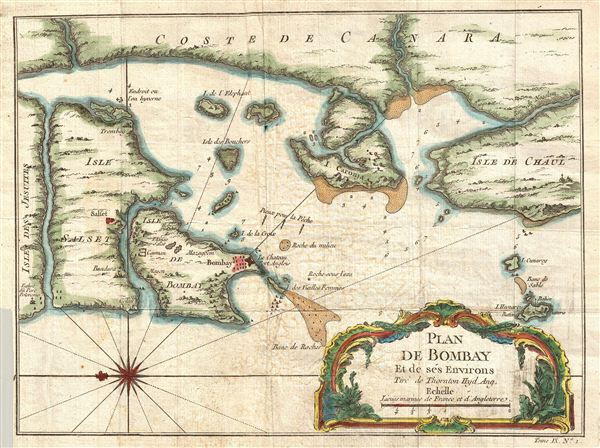
Plan De Bombay et de Ses Environs, Tire de Thornton Hyd. Ang.
c. 1750 (undated) 8 x 10.5 in (20.32 x 26.67 cm)
c. 1750 (undated) 8 x 10.5 in (20.32 x 26.67 cm)
Description
This beautifully hand colored, copper-plate engraved, 1752 map of Bombay (Mumbai), captures the town that was becoming the east India Company's base of operations in India, replacing Surat to the north in light of hostilities there. Bombay was under lease to the east India Company from the British Crown, who had acquired the island from Portugal as part of the marriage agreement between Charles II and Princess Catherine of Braganza. With easy access to the Persian Gulf - Indian Ocean trade route, Bombay quickly became a busy harbor town and important center for British commerce. Drawn by Jacques Nicolas Bellin and published as plate no. 3 in volume 9 of the 1752 French edition of Abbe Provost's L'Histoire Generale des Voyages.
Cartographer
Jacques-Nicolas Bellin (1703 - March 21, 1772) was one of the most important cartographers of the 18th century. With a career spanning some 50 years, Bellin is best understood as geographe de cabinet and transitional mapmaker spanning the gap between 18th and early-19th century cartographic styles. His long career as Hydrographer and Ingénieur Hydrographe at the French Dépôt des cartes et plans de la Marine resulted in hundreds of high quality nautical charts of practically everywhere in the world. A true child of the Enlightenment Era, Bellin's work focuses on function and accuracy tending in the process to be less decorative than the earlier 17th and 18th century cartographic work. Unlike many of his contemporaries, Bellin was always careful to cite his references and his scholarly corpus consists of over 1400 articles on geography prepared for Diderot's Encyclopedie. Bellin, despite his extraordinary success, may not have enjoyed his work, which is described as "long, unpleasant, and hard." In addition to numerous maps and charts published during his lifetime, many of Bellin's maps were updated (or not) and published posthumously. He was succeeded as Ingénieur Hydrographe by his student, also a prolific and influential cartographer, Rigobert Bonne. More by this mapmaker...
Source
Prévost, A., Histoire Générale des Voyages, ou Nouvelle Collection de Toutes les Relations de Voyages par Mer et par Terre..., (Paris: Didot) 1746 - 1759, Supplements 1761 - 1801.
Prévost's Histoire Générale des Voyages is a 15-volume compendium of travel literature initiated by Antoine François Prévost (Provost; 1697 - 1763) in 1746, intended as a universal history of exploration and geography. The initial publication, compiled from 1746 to 1759, spans 15 volumes and draws from a vast array of sources - travelers, explorers, missionaries, merchants, and diplomats - to present detailed narratives of significant global journeys. The work was initially published in Paris by Didot and offers ethnographic, political, religious, and natural observations about the peoples, cultures, flora, fauna, and geography. It is an ambitious attempt to organize knowledge about the world's diversity according to Enlightenment values, reflecting both scientific curiosity and imperial ideology. It functioned as both an informative reference and a literary work, influencing how European audiences understood and imagined distant lands. It proved extremely successful, and both reissues other publishers and pirate editions emerged, most notably Pierre de Hondt's 1747 Dutch edition and Jean-Franćois de la Harpe's 1780 abridged version. In addition to reissues of the original work, between 1768 and 1801, additional expanded volumes emerged, adding new voyages and histories. We have seen some sets with as many as 80 volumes. Over time, the Histoire générale des voyages became one of the most comprehensive and widely read travel collections of the 18th century, notable for blending factual reporting with the period's characteristic intellectual ambition.
Condition
Very good. Original fold lines. Blank on verso. Some water damage.