This item has been sold, but you can get on the Waitlist to be notified if another example becomes available, or purchase a digital scan.
1715 Samuel Thornton Chart of Guzarat (Gujarat) and Bombay (Mumbai)
BombayGuzarat-thornton-1716$900.00

Title
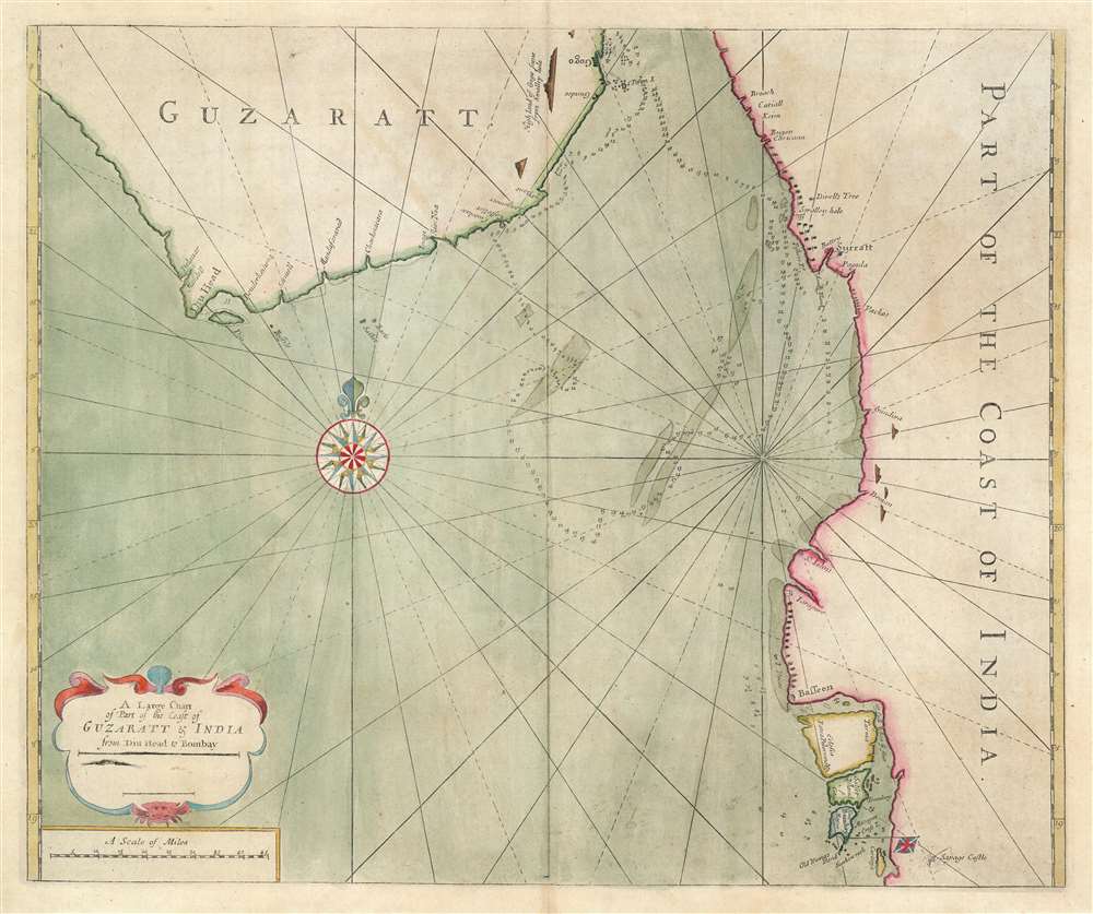
A large chart of part of the coast of GUZARATT and INDIA from Diu head to Bombay.
1716 (undated) 18.5 x 22 in (46.99 x 55.88 cm) 1 : 650000
1716 (undated) 18.5 x 22 in (46.99 x 55.88 cm) 1 : 650000
Description
An extremely rare c. 1716 nautical chart or maritime map illustrating the Gujarat coast of India and the Gulf of Khambhat in the vicinity of Bombay or Mumbai. The map covers the coastline from, roughly Somnath and Diu to Vadodara, and south to Mumbai. The area now occupied by the Mumbai Peninsula is here divided into three islands, Tarma, Salset, and Bombay. Only one of these islands, Tarma, is connected to the mainland via a narrow bridge. On the southernmost island, Bombay is identified with the British flag, making this one of the earliest maps to illustrate Bombay following the 1661 British takeover. At sea, there are tenuous soundings and shadings around the shoals in the Gulf of Khambhat, also known as the Gulf of Cambay, and around Bombay itself.
This map is extremely scarce. We have been able to identify examples in the British Library, the Bibliothèque nationale de France, the Library of Congress, and the New York Public Library, as well as at least two examples in private hands.
English Rule in Bombay (1661 - 1947)
The first English settlement near Bombay, known as the Western Presidency, began in 1618 at Surat in present-day Gujarat. The East India Company established a factory there, protected by a charter from the Mughal Emperor Jahangir. Bombay itself, at the time, was a Portuguese possession, and despite several attempts to seize the island by the British and Dutch, remained so until 1661, when it was given to England in the dowery of Infanta Catherine of Braganza on her marriage to King Charles II. In 1668, in exchange for an annual payment to the crown of £10, Bombay was transferred to the British East Indian Company. The EIC established a factory and fort on the island by 1673. By 1687, Bombay had become the center of regional trade and the East India Company made it the administrative headquarters of its possessions in India.English Mapping of Bombay
Despite Bombay's growing regional importance, good maps were slow to emerge. Seller was the first British cartographer to publish a map of Bombay, which he issued in 1685 in his Atlas Maritimus. This became the default map of Bombay, appearing in subsequent editions of the English Pilot and copied by van Keulen and other cartographers until 1768, when William Nicholson was commissioned to make a new detailed survey of the harbor and adjacent coastline. Likewise, maps of the surrounding coastline were slow to emerge, with the first comprehensive map of the coast not appearing until the 1703 edition of the English Pilot, the Third Book.Publication History and Census
The chart was probably initially drawn by Samuel Thornton, who inherited the English Pilot plates from his father, John Thornton. At least 2 known examples of this map have the Samuel Thornton imprint below the title. This suggests that it was first issued for John and Samuel Thornton's 1703 issue of the English Pilot, Third Book. The present example, corresponding with the Bibliothèque nationale de France example, has the cartographer's name removed, thus it likely postdates the 1715 Richard Mount and Thomas Page takeover of the work. The map is scarce, so it was likely only published in the first Mount and Page edition of the English Pilot before being replaced. Thus, two states are known, this being the second.This map is extremely scarce. We have been able to identify examples in the British Library, the Bibliothèque nationale de France, the Library of Congress, and the New York Public Library, as well as at least two examples in private hands.
CartographerS
Samuel Thornton (1665 - October, 1715) was an English map publisher active in the late 17th and early 18th centuries. Samuel was the son of John Thornton (1641 - 1708), the second major publisher of the English Pilot. Samuel inherited his father's business and the English Pilot plates in 1708, publishing revised edition of the English Pilot, The Third Book in 1711, and The English Pilot, the Fourth Book. Describing the West-Indian Navigation in 1713. Like his father, Thornton enjoyed a mandate from the British East Indian Company and was their primary chart provider. His name is attached to several charts of the India coast that he added to the English Pilot, The Third Book, 1703. When he died, publication of the English Pilot was taken over by Richard Mount and Thomas Page. They, unlike their predecessors, were not mandated by the British East India Company. More by this mapmaker...
Mount and Page (fl. 1701 - 1760) was a London based firm of religious and maritime publishers that flourished in the 18th century. With the publication of the 1732 English Pilot, the Mount and Page name became well-known worldwide as an imprint of nautical charts. The firm was founded at Tower Hill, London, in 1701 by Richard Mount (1654 - 1722) and his apprentice Thomas Page (1780 - March 15, 1733). Mount had previously been in partnership with his father-in-law William Fisher (1631 - 1691) and inherited the business on the latter's death. Page completed his apprenticeship in 1716. Now fully partnered, Mount and Page subsequently acquired the map plates several defunct British nautical chart publishers, including Greenville Collins, Jeremiah Seller, Charles Price, and John and Samuel Thornton - thus nearly monopolizing the British nautical chart business. The firm consequently received several lucrative government contracts and thereby flourished throughout the 18th century, making the fortunes of both families. Successive generations of Mounts and Pages worked in the business, and the families intermarried. Its staple titles were The English Pilot and Navigatio Britannica by John Barrow. By the 1760s, Richard Mount's grandson John Mount (1725 - 1786) was able to retire to Berkshire where he built the stately mansion, Wasing Place. John's son William (1753 - 1815) was the last to work in the map business, and later generations went into politics. Learn More...
Source
The English Pilot, The Third Book, (London) c. 1715.
Condition
Very good. Original pressmark.
References
OCLC 764019597. Gole,S., Early Maps of India, page 100, 27-F.