This item has been sold, but you can get on the Waitlist to be notified if another example becomes available, or purchase a digital scan.
1764 Bellin Plan or Map of the Cape of Good Hope (Cape Town), South Africa
BonneEsperance-bellin-1764$175.00

Title
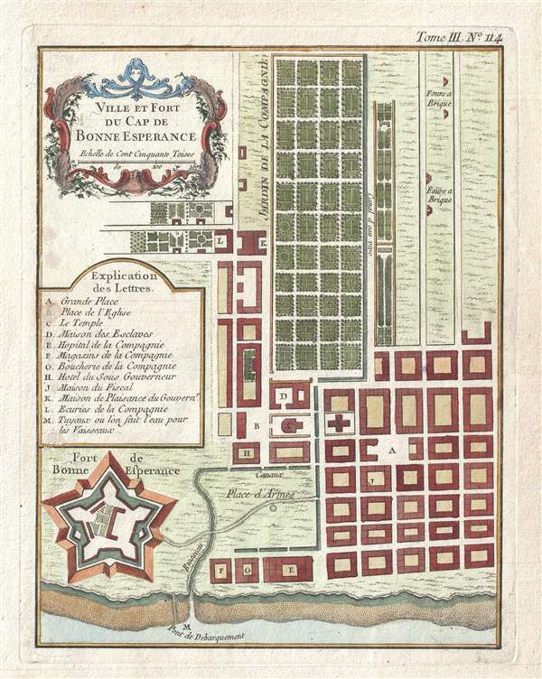
Ville et Fort du Cap de Bonne Esperance.
1764 (undated) 9.5 x 7.5 in (24.13 x 19.05 cm) 1 : 7000
1764 (undated) 9.5 x 7.5 in (24.13 x 19.05 cm) 1 : 7000
Description
This is a scarce c.1764 plan or map of Cape Town, South Africa by French cartographer Bellin. The map depicts the city and fort of Cape Town in considerable detail with particular emphasis on the identifications of individual buildings and gardens. A key near the left border lists the 12 locations noted on the map. The Fort de Bonne Experance is detailed in the bottom left.
Built in the 17th century, the fort was located on the original coastline of Table Bay. With land reclamations, the current location of the fort has moved considerably inland. It is today considered the oldest existing colonial building in South Africa.
This map was issued by Jacques Nicolas Bellin in c.1764.
Cartographer
Jacques-Nicolas Bellin (1703 - March 21, 1772) was one of the most important cartographers of the 18th century. With a career spanning some 50 years, Bellin is best understood as geographe de cabinet and transitional mapmaker spanning the gap between 18th and early-19th century cartographic styles. His long career as Hydrographer and Ingénieur Hydrographe at the French Dépôt des cartes et plans de la Marine resulted in hundreds of high quality nautical charts of practically everywhere in the world. A true child of the Enlightenment Era, Bellin's work focuses on function and accuracy tending in the process to be less decorative than the earlier 17th and 18th century cartographic work. Unlike many of his contemporaries, Bellin was always careful to cite his references and his scholarly corpus consists of over 1400 articles on geography prepared for Diderot's Encyclopedie. Bellin, despite his extraordinary success, may not have enjoyed his work, which is described as "long, unpleasant, and hard." In addition to numerous maps and charts published during his lifetime, many of Bellin's maps were updated (or not) and published posthumously. He was succeeded as Ingénieur Hydrographe by his student, also a prolific and influential cartographer, Rigobert Bonne. More by this mapmaker...
Source
Bellin, J. N., Petite Atlas Maritime, (Paris) 1764.
Condition
Very good. Minor spotting. Original platemark visible.
References
Rumsey 6903.332. OCLC 165307429.