This item has been sold, but you can get on the Waitlist to be notified if another example becomes available, or purchase a digital scan.
1939 Cram City Plan or Map of Boston, Massachusetts
Boston-cram-1939$150.00

Title
Cram's Street Map of Boston.
1939 (undated) 32 x 24 in (81.28 x 60.96 cm) 1 : 31680
1939 (undated) 32 x 24 in (81.28 x 60.96 cm) 1 : 31680
Description
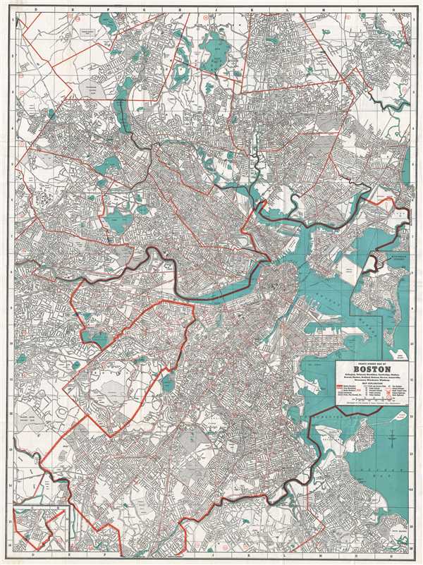
This is a beautiful 1939 map or plan of the city of Boston, Massachusetts and its surroundings issued by The George F. Cram Company, Inc. It covers from Woburn south to Hyde Park and from Belmont east to Boston Harbor. Includes the areas of Arlington Belmont, Boston, Brookline, Cambridge, Chelsea, Everett, Malden, Medford, Melrose, Revere, Somerville, Watertown, Winchester, and Winthrop.
The map is extremely detailed and notes individual streets, neighborhoods, ponds, parks, bridges, buildings, lakes, cemeteries, roads, railways, island, rivers, and a host of additional topographical features. Two insets detailing the Winthrop Extension and Southern Extension are included.
Verso features four additional maps depicting the Boston elevated railway system, Boston business and hotel district, trunk highways, and a regional map. An index of places of historical interest, public buildings, theaters, hotels, etc. Issued by The George F. Cram Company, Inc.
Cartographer
George Franklin Cram (May 20, 1842 - 1928) was an American map publisher active in the late 19th and early 20th centuries. During the American Civil War, Cram served as a staff cartographer for the Union General Ulysses S. Grant and participated in Sherman's 'March to the Sea'. In 1867, after being discharged from the army, George Cram moved to Chicago, where he founded 'Blanchard and Cram' with his uncle Rufus Blanchard Evanston. Blanchard and Cram was a supply house for the book trade - though they also published a few maps during this period. This short lived business was destroyed in the 1871 by the Great Chicago Fire. After the fire, recognizing a business opportunity in the burgeoning railroad industry, Cram reinvented himself as cartographic publisher, opening the Cram Map Depot. Like fellow Chicago publisher Rand McNally, Cram took advantage of the economical wax engraving processes to inexpensively produce maps in vast quantities. His signature publication, the Unrivaled Atlas of the World became the world's best-selling atlas and was published from the 1880s to 1952. On retiring in 1921, Cram sold his company to Edward A. Peterson of the National Map Company (Scarborough Company). Peterson moved the company to Indianapolis where, following Cram's death, he rebranded the National Map Company as the George F. Cram Company, surely thinking to capitalize on the established identity of the firm. In 1930 he entered the globe market for which the firm was best known from the mid-20th century. In time the firm expanded globally passing becoming a major concern. Loren B. Douthit became company president in 1968 and the Douthit family ran the business until Herff Jones, Inc., bought the company in 2005. More by this mapmaker...
Condition
Very good. Minor wear along original fold lines. Minor foxing. Accompanied by original binder and 32 page guide.
References
OCLC: 702682154.