1867 Mitchell City Plan or Map of Boston, Massachusetts
Boston-mitchell-1867-2$250.00

Title
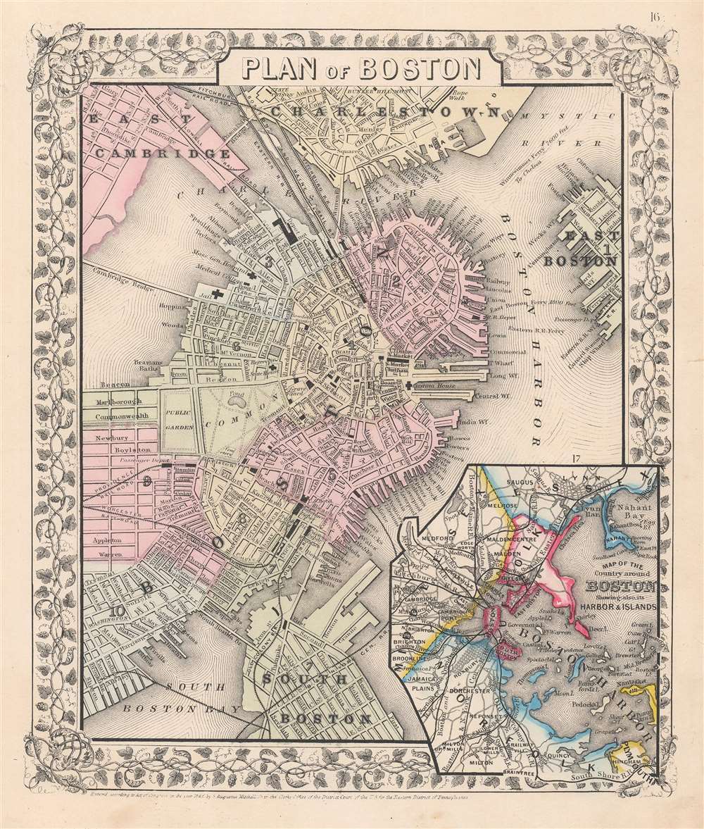
Plan of Boston.
1867 (dated) 11.5 x 9.5 in (29.21 x 24.13 cm) 1 : 16900
1867 (dated) 11.5 x 9.5 in (29.21 x 24.13 cm) 1 : 16900
Description
This is Samuel Augustus Mitchell Jr.'s 1867 city plan or map of Boston, Massachusetts. Aside from the city's center, this map depicts East Cambridge, Charlestown, East Boston, and South Boston. It offers wonderful insight into Boston's history, including references to parks, individual streets, railroad lines, piers, ferries, wharfs, important buildings, and other landmarks. Neighborhoods are color coded with pastels according to the boundaries of city wards. An inset in the lower right quadrant depicts Boston Harbor and the greater Boston area including Plymouth, Norfolk, Middlesex, Suffolk, and Essex Counties. The whole is surrounded by the attractive vine motif border used in Mitchell atlases issued between 1866 and 1879. This is one of the more attractive atlas maps of Boston to appear in the mid-19th century.
Publication History
Prepared by S. A. Mitchell Jr. for inclusion as plate 16 in the 1867 edition of Mitchell's New General Atlas. Dated and copyrighted, 'Entered according to Act of Congress in the Year 1867 by S. Augustus Mitchell Jr. in the Clerk's Office of the District Court of the U.S. for the Eastern District of Pennsylvania.'Cartographer
Samuel Augustus Mitchell (March 20, 1792 - December 20, 1868) began his map publishing career in the early 1830s. Mitchell was born in Bristol, Connecticut. He relocated to Philadelphia in 1821. Having worked as a school teacher and a geographical writer, Mitchell was frustrated with the low quality and inaccuracy of school texts of the period. His first maps were an attempt to rectify this problem. In the next 20 years Mitchell would become the most prominent American map publisher of the mid-19th century. Mitchell worked with prominent engravers J. H. Young, H. S. Tanner, and H. N. Burroughs before attaining the full copyright on his maps in 1847. In 1849 Mitchell either partnered with or sold his plates to Thomas, Cowperthwait and Company who continued to publish the Mitchell's Universal Atlas. By about 1856 most of the Mitchell plates and copyrights were acquired by Charles Desilver who continued to publish the maps, many with modified borders and color schemes, until Mitchell's son, Samuel Augustus Mitchell Junior, entered the picture. In 1859, S.A. Mitchell Jr. purchased most of the plates back from Desilver and introduced his own floral motif border. From 1860 on, he published his own editions of the New General Atlas. The younger Mitchell became as prominent as his father, publishing maps and atlases until 1887, when most of the copyrights were again sold and the Mitchell firm closed its doors for the final time. More by this mapmaker...
Source
Mitchell Jr., S. A., Mitchell's New General Atlas, Containing Maps Of The Various Countries Of The World, Plans Of Cities, Etc. Embraced In Fifty-Eight Quarto Maps, Forming A Series Of Ninety-Two Maps And Plans, Together With Valuable Statistical Tables, 1867.
Mitchell's New General Atlas was published by Samuel Augustus Mitchell, Jr., the son of the prolific cartographer Samuel Augustus Mitchell. Many of the plates are derived from the his father's Mitchell's Universal Atlas, but not directly. The Mitchell's Universal Atlas was initially sold to Thomas, Cowperthwait, and Company in 1849, and again to Charles Deliver in 1856. It was Deliver who introduced the new vibrant color scheme, abandoning the older Mitchell's Universal Atlas green borders and themes for bright reds, blues, and yellows. Samuel Augustus Mitchell, Jr. acquired the Deliver plates in 1859. He added his own floral motif border, but doubled down on the vibrant color scheme, thus introducing to the American public the most vividly colored American atlas of the 19th century. In 1860, he published the first edition of his New General Atlas and, despite a slump in sales during the American Civil War, attained a level of success to rival his father. Mitchell would continue to publish the New General Atlas until 1887, when the firm formally closed.
Condition
Very good. Closed margin tears professionally repaired on verso.
References
Rumsey 0565.011. Phillips (Atlases) 831-16.