This item has been sold, but you can get on the Waitlist to be notified if another example becomes available, or purchase a digital scan.
1891 Rand McNally Map or Plan of Boston, Massachusetts
Boston-randmcnally-1893-2$75.00

Title
Map of Boston.
1893 (dated) 27 x 20 in (68.58 x 50.8 cm) 1 : 15600
1893 (dated) 27 x 20 in (68.58 x 50.8 cm) 1 : 15600
Description
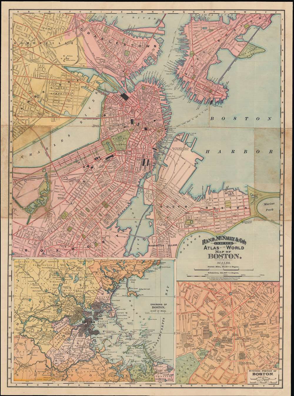
This is an 1891 Rand McNally city plan or map Boston, Massachusetts. Coverage extends from Charlestown and Somerville to Roxbury and Washington Village in the south. Two inset maps along the bottom margin detail the environs and the business portion of Boston. This highly detailed map notes several parks, piers, railway and ferry lines, and other topographical features. Individual streets and buildings are identified, including courts, museums, insane asylums, etc.
Expanding City
In the period just prior to this map's production, Boston had expanded continuously for several decades through two means. One was the annexation of surrounding towns (West Roxbury, Brighton, Dorchester, etc.) and the other was through land reclamation, shaving off the tops of hills in and around the city (including Beacon Hill) and using the debris to fill in portions of the Charles River and wetlands. The Great Fire of 1872 also provided rubble for further land reclamation. The most significant of these projects was the filling in of Back Bay.Publication History and Census
This map was issued as plate nos. 38 and 39 in the 1893 edition of Rand McNally and Company's Indexed Atlas of the World- possibly the finest atlas Rand McNally ever issued. It is held by a handful of libraries in the United States.Cartographer
Rand, McNally and Co. (fl. 1856 - present) is an American publisher of maps, atlases and globes. The company was founded in 1856 when William H. Rand, a native of Quincy, Massachusetts, opened a print shop in Chicago. Rand hired the recent Irish immigrant Andrew McNally to assist in the shop giving him a wage of 9 USD per week. The duo landed several important contracts, including the Tribune's (later renamed the Chicago Tribune) printing operation. In 1872, Rand McNally produced its first map, a railroad guide, using a new cost effective printing technique known as wax process engraving. As Chicago developed as a railway hub, the Rand firm, now incorporated as Rand McNally, began producing a wide array of railroad maps and guides. Over time, the firm expanded into atlases, globes, educational material, and general literature. By embracing the wax engraving process, Rand McNally was able to dominate the map and atlas market, pushing more traditional American lithographic publishers like Colton, Johnson, and Mitchell out of business. Eventually Rand McNally opened an annex office in New York City headed by Caleb S. Hammond, whose name is today synonymous with maps and atlases, and who later started his own map company, C. S. Hammond & Co. Both firms remain in business. More by this mapmaker...
Source
Rand McNally and Co., Rand, McNally and Co's Indexed Atlas of the World, (Chicago) 1893.
Condition
Very good. Original centerfold exhibits minor wear. Text on verso.
References
OCLC 367572177, 945571857. Rumsey 3565.071 (1897 edition). Philips (atlases) 1026 (1898 edition).