This item has been sold, but you can get on the Waitlist to be notified if another example becomes available, or purchase a digital scan.
1875 Sampson Map of Boston, Massachusetts
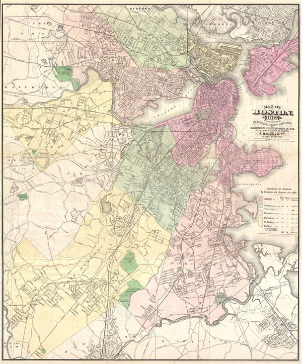
Boston-sampson-1875$300.00

Title
Map of Boston 1875.
1875 (dated) 33 x 27 in (83.82 x 68.58 cm)
1875 (dated) 33 x 27 in (83.82 x 68.58 cm)
Description
An uncommon large format map of Boston, Massachusetts issued by Mary Sampson for issue in the 1875 edition of J. B. Beers' Atlas of Middlesex County Mass. Covers all of Boston as well as the adjacent communities of Somerville, Charleston, Cambridge, Brighton, Brookline, West Roxbury, Dorchester, South Boston, east Boston, everet, and Chelsea. Offers street by street detail throughout with topographical features, parks, ponds, rail lines, and cemeteries noted. Hand tinted in various pastels to illustrate community boundaries.
CartographerS
Mary Otis Sampson (fl. 1880 - 1910) was a Boston based publisher and president of Sampson Publishing Company. She is known to have studied art at the Boston Art Club and to have worked as an Art Editor for Photo Era a photography publication active around the turn of the century. She is the author ofThe Human Figure Beautiful, which she self-published in 1910. Ms. Sampson never married and lived most of her adult life at 39 Addington Road, Brookline, MA. Her cartographic contributions are limited to several Boston maps produced in association other publishers, including William Edwards Murdock and Charles Haynes Davenport. Mary most likely met Murdock and Davenport at the Boston Art Club, where all three were members. More by this mapmaker...
The Beers family (Fredrick, Silas, James and Daniel) (fl. c. 1850 - 1886), along with Charles and Augustus Warner, were prominent map publishers working from the 1850s to the late 1880s. Often publishing under the Warner & Beers designation, the combined firms produced a series of important state and county atlases and map of much of the northeastern United States. Many of their regional maps are among the most detailed and well laid out maps ever produced of their respective regions. Because Warner & Beers county maps were often detailed down to the individual homes and landowners, they have become highly sought after by general and family historians. In additional to producing maps of surpassing detail, Warner & Beers also maintained an earlier generation's attention to detail and quality while publishing in an era ever increasingly dominated by the low cost printing methods used by the publishing empires of Rand McNally and George Cram. Learn More...
Source
Beers, J. B., The Middlesex County Mass Atlas, 1875.
Condition
Good. Original fold lines exhibit some wear. Some creasing in the left hand quadrants of the amp. A couple closed verso repairs. Else clean.